Kentucky Route 37
Kentucky Route 37 (KY 37) is an 18.730-mile-long (30.143 km) long east-west, two-lane, rural state highway in Kentucky managed by the Kentucky Transportation Cabinet.
| ||||
|---|---|---|---|---|
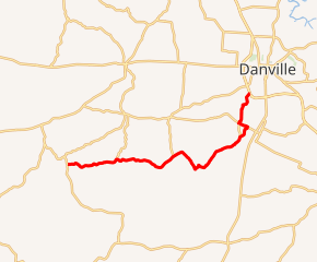
KY 37 highlighted in red | ||||
| Route information | ||||
| Maintained by KYTC | ||||
| Length | 18.730 mi[1] (30.143 km) | |||
| Major junctions | ||||
| West end | ||||
| East end | ||||
| Location | ||||
| Counties | Boyle | |||
| Highway system | ||||
| ||||

KY 37 begins at KY 243 near Forkland and terminates at US 127 bypass west of Danville. It is entirely contained in Boyle County.
Major intersections
The entire route is in Boyle County.
| Location | mi[1] | km | Destinations | Notes | |
|---|---|---|---|---|---|
| | 0.000 | 0.000 | Western terminus | ||
| | 3.720 | 5.987 | Southern terminus of KY 110 | ||
| | 8.281 | 13.327 | Southern terminus of KY 1822 | ||
| | 13.733 | 22.101 | Southern terminus of KY 3365 | ||
| Junction City | 15.666 | 25.212 | South end of KY 300 overlap | ||
| | 16.301 | 26.234 | North end of KY 300 overlap | ||
| Danville | 18.730 | 30.143 | Eastern terminus | ||
| 1.000 mi = 1.609 km; 1.000 km = 0.621 mi | |||||
Alternate names
KY 37 has other names along its path:
- Forkland Road from its western terminus to 3 mi (5 km) south of Junction City.
- White Oak Road to its intersection with KY 300
- Stewarts Lane to its eastern terminus
References
- "Kentucky Transportation Cabinet - Division of Planning". Archived from the original on 2007-04-30. Retrieved 2008-10-08.
External links
This article is issued from Wikipedia. The text is licensed under Creative Commons - Attribution - Sharealike. Additional terms may apply for the media files.