Kentucky Route 253
Kentucky Route 253 (KY 253) is a 3.2-mile-long (5.1 km) state highway in the U.S. state of Kentucky. The highway travels through rural areas of Hardin.
| ||||
|---|---|---|---|---|
KY 253 highlighted in red | ||||
| Route information | ||||
| Maintained by KYTC | ||||
| Length | 3.2 mi[1] (5.1 km) | |||
| Major junctions | ||||
| South end | ||||
| North end | ||||
| Location | ||||
| Counties | Hardin | |||
| Highway system | ||||
| ||||

Route description
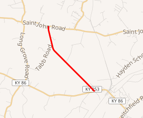
KY 253 begins at an intersection with KY 86 (Hardinsburg Road/West Main Street) west of Cecilia, within Hardin County. Here, the roadway continues as Lewis Lane. It travels to the northwest and curves to the north-northwest. It then curves to the north-northeast and meets its northern terminus, an intersection with KY 1357 (St. John Road).[1]
Major intersections
The entire route is in Hardin County.
| Location | mi[1] | km | Destinations | Notes | |
|---|---|---|---|---|---|
| | 0.0 | 0.0 | Southern terminus | ||
| | 3.2 | 5.1 | Northern terminus | ||
| 1.000 mi = 1.609 km; 1.000 km = 0.621 mi | |||||
See also


References
- Google (May 29, 2016). "Kentucky Route 253" (Map). Google Maps. Google. Retrieved May 29, 2016.
This article is issued from Wikipedia. The text is licensed under Creative Commons - Attribution - Sharealike. Additional terms may apply for the media files.