Kentucky Route 234
Kentucky Route 234 (KY 234) is a 20.033-mile-long (32.240 km) north–south state highway in southern Kentucky. The southern terminus of the route is at KY 101 six miles (10 km) north of Scottsville. The northern terminus is at U.S. Route 68 (US 68) and KY 80 in downtown Bowling Green.
| ||||
|---|---|---|---|---|
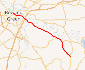
KY 234 highlighted in red | ||||
| Route information | ||||
| Maintained by KYTC | ||||
| Length | 20.033 mi[1] (32.240 km) | |||
| Major junctions | ||||
| West end | ||||
| East end | ||||
| Location | ||||
| Counties | Allen, Warren | |||
| Highway system | ||||
| ||||

Although the route follows a generally east–west alignment for most of its length, Kentucky Transportation Cabinet route logs list the route as north–south.
Route description
KY 234 is known solely by its numerical designation from KY 101 to the Allen-Warren county line. Upon entering Warren County, KY 234 becomes Cemetery Road.
A short distance east of the Bowling Green city limits, KY 234 interchanges with Interstate 65 at exit 26. The route continues west into Bowling Green, retaining the Cemetery Road name to an intersection with U.S. Route 31W. West of US 31W, KY 234 becomes Fairview Avenue for a brief stretch to Park Street, where KY 234 splits into a pair of parallel one-way streets. KY 234 northbound follows Sixth Avenue to the northern terminus of the route at US 68/KY 80,while KY 234 southbound utilizes Seventh Avenue between US 68/KY 80 and Park Street.
History
KY 234 originally passed over I-65 with no connection to the expressway.[2] In 2002, the junction of KY 234 and I-65 was altered from an overpass to an interchange in order to provide a direct route from the interstate to downtown Bowling Green. Construction of the new interchange, designated exit 26 on I-65, was completed in late 2002.[3]
Prior to the opening of the new intersection, the Cemetery Road portion of KY 234 between I-65 and US 31W was widened from two to five lanes to accommodate the anticipated increase in traffic flow.[4]
Future
The KY 234 bridge over Drakes Creek in southeastern Warren County will be replaced by a new bridge sometime around Fall 2017. The new bridge will feature three lanes, including a left-turning lane at Roger Porter Road. Scotty's Contracting and Stone is the constructor for the US $3.5 million dollar project. Funding for the bridge is entirely provided to the KYTC by the Federal Bridge Replacement Fund.[5]
Major intersections
| County | Location | mi[1] | km | Destinations | Notes |
|---|---|---|---|---|---|
| Warren | Bowling Green | 20.033 | 32.240 | ||
| 19.134 | 30.793 | ||||
| Mount Victor | 17.124 | 27.558 | |||
| | 16.750 | 26.957 | I-65 exit 26 | ||
| | 16.538 | 26.615 | |||
| Claypool | 6.746 | 10.857 | |||
| Allen | | 5.147 | 8.283 | ||
| | 0.000 | 0.000 | |||
| 1.000 mi = 1.609 km; 1.000 km = 0.621 mi | |||||
References
- "Kentucky Transportation Cabinet – Division of Planning – Highway Information System Official Milepoint Route Log Extract". Retrieved 2007-04-10.
- County Road Series Map – Warren County, Kentucky (PDF) (Map) (1993 ed.). Kentucky Transportation Cabinet. Archived from the original (PDF) on 2011-07-21. Retrieved 2007-04-10.
- "KentuckyRoads.com – New Interchange Opens on I-65". Retrieved 2007-04-10.
- "KentuckyRoads.com – KY 234 Work on Schedule in Bowling Green". Retrieved 2007-04-10.
- French, Jackson (February 25, 2017). "Bridge replacement in progress".Bowling Green Daily News, p. A1.