Kentucky Route 198
Kentucky Route 198 (KY 198) is a 12.5-mile-long (20.1 km) state highway in the U.S. state of Kentucky. The highway connects Yosemite and Turnersville with mostly rural areas of Casey and Lincoln counties.
| ||||
|---|---|---|---|---|
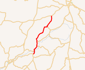
KY 198 highlighted in red | ||||
| Route information | ||||
| Maintained by KYTC | ||||
| Length | 12.5 mi[1] (20.1 km) | |||
| Major junctions | ||||
| South end | ||||
| North end | ||||
| Location | ||||
| Counties | Casey, Lincoln | |||
| Highway system | ||||
| ||||

Route description
KY 198 begins at an intersection with KY 70 in Yosemite, within Casey County. It travels to the northeast and immediately crosses Knob Lick Creek. It curves to a nearly due north direction. It crosses over the Green River and enters Middleburg. It intersects the southern terminus of KY 3196 (College Street). KY 198 curves to the northwest and intersects the eastern terminus of KY 1552 (Short Town Road). It heads north and then northeast and intersects the western terminus of KY 3270 (Indian Creek Road). The highway heads north and intersects the southern terminus of KY 698. It then enters Lincoln County. It curves to the northeast and crosses over Pine Lick Creek. It crosses over Peltis Fork and then curves to the north-northeast. The highway passes McKinney Cemetery before curving to the east. It then enters McKinney. Just before an intersection with Durham Street, it curves to the north-northwest. It passes McKinney Elementary School and curves to the east-northeast. It crosses some railroad tracks and intersects the northern terminus of KY 1778 (Geneva–McKinney Road). KY 198 heads to the north-northeast and then the northeast. It then curves back to the north-northeast and parallels Peyton Creek. After a crossing of Martins Branch, it meets its northern terminus, an intersection with KY 78 in Turnersville.[1]
Major intersections
| County | Location | mi[1] | km | Destinations | Notes |
|---|---|---|---|---|---|
| Casey | Yosemite | 0.0 | 0.0 | Southern terminus | |
| Middleburg | 0.6 | 0.97 | Southern terminus of KY 3196 | ||
| 0.9 | 1.4 | Eastern terminus of KY 1552 | |||
| | 2.6 | 4.2 | Western terminus of KY 3270 | ||
| | 3.7 | 6.0 | Southern terminus of KY 698 | ||
| Lincoln | McKinney | 9.6 | 15.4 | Northern terminus of KY 1778 | |
| Turnersville | 12.5 | 20.1 | Northern terminus | ||
| 1.000 mi = 1.609 km; 1.000 km = 0.621 mi | |||||
See also


References
- Google (May 22, 2016). "Kentucky Route 198" (Map). Google Maps. Google. Retrieved May 22, 2016.