Keeler (lunar crater)
Keeler is a large lunar impact crater that lies on the Moon's far side. It is connected along the eastern edge to Heaviside, a walled plain of similar dimensions. Keeler, however, is the younger of the two formations, with more clearly delineated features. To the northeast of Keeler is the smaller crater Stratton, and to the northwest lies Ventris.
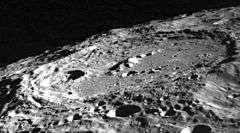
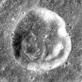
 Lunar Orbiter 2 image | |
| Coordinates | 10.2°S 161.9°E |
|---|---|
| Diameter | 160 km |
| Depth | Unknown |
| Colongitude | 200° at sunrise |
| Eponym | James E. Keeler |
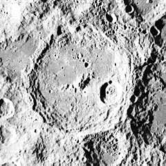
The outer rim of Keeler is roughly circular, with a straight segment where it is joined to Heaviside. The northern portion of the rim is more irregular, with an outward protuberance to the north-northwest. Portions of the inner wall have a terrace structure, especially along the southern half. Within the crater interior, Planté lies on the eastern floor, adjacent to the inner wall. There is an interior ridge that runs from about the midpoint toward the west-southwest. The floor is generally level, with some areas of irregularity to the south. A few small and tiny craterlets mark the interior plain.
Measurements with the electron reflectometer instrument on board the Lunar Prospector showed that this crater is one of a number of impact sites that show demagnetization. The low magnetic reading lies at the center of this crater, and the reduced field extends outward to about one and a half crater diameters. Scientists believe that shock demagnetization is the cause.[1]
Prior to naming, Keeler was called Crater 302 by the IAU.[2]
Satellite craters
By convention these features are identified on lunar maps by placing the letter on the side of the crater midpoint that is closest to Keeler.
| Keeler | Latitude | Longitude | Diameter |
|---|---|---|---|
| L | 13.3° S | 163.2° E | 71 km |
| S | 11.4° S | 158.0° E | 30 km |
| U | 9.1° S | 156.9° E | 29 km |
| V | 8.9° S | 158.3° E | 53 km |
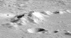
 Keeler S crater photographed by Apollo 8
References
- Halekas, J. S.; Mitchell, D. L.; Lin, R. P.; Frey, S.; Hood, L. L.; Acuna, M. H.; Binder, A. B. (May 2001). "Demagnetization Signatures of Lunar Impact Craters" (PDF). American Geophysical Union, Spring Meeting 2001, abstract #GP22A-11. Bibcode:2001AGUSM..GP22A11H. Retrieved 2010-01-28.
- Lunar Landmark Locations - Apollo 8, 10, 11, and 12 Missions. NASA technical note D-6082. Manned Spacecraft Center, Houston, Texas. November 1970. Figure 4.
Other sources
- Andersson, L. E.; Whitaker, E. A. (1982). NASA Catalogue of Lunar Nomenclature. NASA RP-1097.CS1 maint: ref=harv (link)
- Blue, Jennifer (July 25, 2007). "Gazetteer of Planetary Nomenclature". USGS. Retrieved 2007-08-05.CS1 maint: ref=harv (link)
- Bussey, B.; Spudis, P. (2004). The Clementine Atlas of the Moon. New York: Cambridge University Press. ISBN 978-0-521-81528-4.CS1 maint: ref=harv (link)
- Cocks, Elijah E.; Cocks, Josiah C. (1995). Who's Who on the Moon: A Biographical Dictionary of Lunar Nomenclature. Tudor Publishers. ISBN 978-0-936389-27-1.CS1 maint: ref=harv (link)
- McDowell, Jonathan (July 15, 2007). "Lunar Nomenclature". Jonathan's Space Report. Retrieved 2007-10-24.CS1 maint: ref=harv (link)
- Menzel, D. H.; Minnaert, M.; Levin, B.; Dollfus, A.; Bell, B. (1971). "Report on Lunar Nomenclature by the Working Group of Commission 17 of the IAU". Space Science Reviews. 12 (2): 136–186. Bibcode:1971SSRv...12..136M. doi:10.1007/BF00171763.CS1 maint: ref=harv (link)
- Moore, Patrick (2001). On the Moon. Sterling Publishing Co. ISBN 978-0-304-35469-6.CS1 maint: ref=harv (link)
- Price, Fred W. (1988). The Moon Observer's Handbook. Cambridge University Press. ISBN 978-0-521-33500-3.CS1 maint: ref=harv (link)
- Rükl, Antonín (1990). Atlas of the Moon. Kalmbach Books. ISBN 978-0-913135-17-4.CS1 maint: ref=harv (link)
- Webb, Rev. T. W. (1962). Celestial Objects for Common Telescopes (6th revised ed.). Dover. ISBN 978-0-486-20917-3.CS1 maint: ref=harv (link)
- Whitaker, Ewen A. (1999). Mapping and Naming the Moon. Cambridge University Press. ISBN 978-0-521-62248-6.CS1 maint: ref=harv (link)
- Wlasuk, Peter T. (2000). Observing the Moon. Springer. ISBN 978-1-85233-193-1.CS1 maint: ref=harv (link)
External links
- LTO-85C1 Plante — L&PI topographic map of crater interior.