Kanjut Sar
Kanjut Sar (Urdu: کنجت سر) or Kunjudh Sar as pronounced in "Wakhi" is a mountain located in the Hispar Muztagh, a subrange of the Karakoram mountain range. Kunjudh Sar in wakhi language mean that which overlooks Kunjudh, or above Kunjudh, while Khujudh is the wakhi name for Lower Hunza. It is the 26th highest mountain on Earth and the 11th highest in Pakistan. According to many residents of Shimshal, Kanjut Sar is the name of the adjacent peak Yukshin Gardan Sar, and vice versa. In Shimshal village, the original namings are widely accepted and used, as opposed to what is recognised internationally.
| Kanjut Sar کنجت سر | |
|---|---|
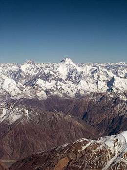 Yukshin Gardan Sar (background left) and Kanjut Sar (background centre) | |
| Highest point | |
| Elevation | 7,760 m (25,460 ft) [1] Ranked 26th |
| Prominence | 1,660 m (5,450 ft) [1] |
| Listing | Ultra |
| Coordinates | 36°12′18″N 75°25′06″E [1] |
| Geography | |
 Kanjut Sar کنجت سر | |
| Parent range | Hispar Muztagh, Karakoram |
| Climbing | |
| First ascent | 1959 by Camillo Pellissier |
| Easiest route | snow/ice climb |
Kanjut Sar consists of two peaks:
- Kanjut Sar I at 7,760 metres (25,459 ft).
- Kanjut Sar II, to the south east of I, at 6,831 m (22,411 ft).
Kanjut Sar I was first climbed in 1959 by Camillo Pellissier, member of an Italian expedition directed by Guido Monzino. Between 1981, August 4 and 6, 7 Japanese climbers of the same expedition climbed to the top.[2] In 2010 Russian-American expedition attempted to climb on the Eastern Ridge of Kanjut Sar and reached 7450 m, turning in bad weather.
See also
- Highest mountains of the world
- List of Ultras of the Karakoram and Hindu Kush
- List of mountains in Pakistan
References
- "Karakoram and India/Pakistan Himalayas Ultra-Prominences". peaklist.org. Retrieved 2010-08-05.
- AAJO 1982
External links