Kamarang River
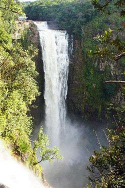
Kamarang River is a river of the Essequibo River basin. The river originates in Venezuela where it is called Río Camarán or Río Camurán. Its source is located right next to the Troncal 10, in the middle of the Gran Sabana region. The nascent river first flows in parallel to the road in a southeasterly direction. It then passes the road a few meters after the Campamento Kamoiran. Here the river forms the Kamoiran rapids. Its course then turns more eastward for several kilometers through open Savannah. Shortly after entering the disputed Guayana Esequiba territory in Guyana the river drops roughly 160 meters at the impressive Kamarang falls creating a 40 meter wide water curtain.
| Kamarang River | |
|---|---|
 | |
| Location | |
| Country | Venezuela, Guyana (Disputed) |
| Physical characteristics | |
| Source | |
| • elevation | 1,350 m (4,430 ft) |
| Mouth | |
• elevation | 480 m (1,570 ft) |
The Kamarang River then flows through a deep forested gorge first north-, then eastbound.[1] This area is very remote and inhabited by the Arekuna people and rarely visited as it is difficult to access from both Guyana and Venezuela. The river then flows east through the forest until meeting the Mazaruni River at the mining village of Kamarang.
References
- Rand McNally, The New International Atlas, 1993.