Kaeng Sopha
Kaeng Sopha (Thai: แก่งโสภา) is a subdistrict in the Wang Thong District of Phitsanulok Province, Thailand.
Kaeng Sopha แก่งโสภา | |
|---|---|
Subdistrict | |
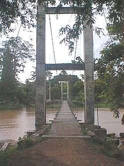 Bridge over Wang Thong River near the Kaeng Song Waterfall, Kaeng Sopha | |
| Coordinates: 16°52′00″N 100°50′00″E | |
| Country | Thailand |
| Province | Phitsanulok |
| District | Wang Thong |
| Population (2005) | |
| • Total | 11,949 |
| Time zone | UTC+7 (ICT) |
| Postal code | 65130 |
| Geocode | 650806 |
| Chief roadway | Route 12 |
| Chief watercourse | Wang Thong River |
Geography
Kaeng Sopha lies in the Nan Basin, which is part of the Chao Phraya Watershed. The Wang Thong River flows through the subdistrict.
Administration
The following is a list of the subdistrict's mubans, which roughly correspond to the villages:[1]
| No. | English | Thai |
| 1 | Ban Poi | บ้านปอย |
| 2 | Ban Kaeng Gula | บ้านแก่งกุลา |
| 3 | Ban Huay Phloo | บ้านห้วยพลู |
| 4 | Ban Kao Noi | บ้านเขาน้อย |
| 5 | Ban Muang Hom | บ้านม่วงหอม |
| 6 | Ban Lao Ya | บ้านเหล่าหญ้า |
| 7 | Ban Sap Phrai Wan | บ้านทรัพย์ไพรวัลย์ |
| 8 | Ban Sap Jayrin | บ้านทรัพย์เจริญ |
| 9 | Ban Kaeng Song | บ้านแก่งซอง |
| 10 | Ban Pong Pa | บ้านโป่งปะ |
| 11 | Ban Noi Muang Hom | บ้านน้อยม่วงหอม |
| 12 | Ban Kaeng Gula Nuea (North Kaeng Gula) | บ้านแก่งกุลาเหนือ |
| 13 | Ban Mai Kao Noi | บ้านใหม่เขาน้อย |
This article is issued from Wikipedia. The text is licensed under Creative Commons - Attribution - Sharealike. Additional terms may apply for the media files.