Kabbinale
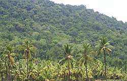
Kabbinale is a village at the foot hills of the Western Ghats (Sahyadri) Agumbe range, situated in the Hebri Taluk of the Udupi district of Karnataka state, India. In the Kannada language, kabbinale means "crushing unit of sugarcane". The nearest airport is at Mangaluru, which is at a distance of 86 km from Kabbinale.
Kabbinale | |
|---|---|
village | |
 | |
| Country | |
| State | Karnataka |
| District | Udupi |
| Taluk | Hebri |
| Government | |
| • Body | Gram panchayat |
| Languages | |
| • Local | Tulu |
| Time zone | UTC+5:30 (IST) |
| ISO 3166 code | IN-KA |
| Vehicle registration | KA 20 |
| Website | karnataka |
This small village is around 50 km from Udupi Town, and the nearest town is Hebri, which is around 20 km from Kabbinale. The area is covered by thick rain forests, evergreen, and populated by wild animals. The last settlement, called Kuchur, is around 1500 feet above sea level. Korth Baill is the highest, and last point of village Kabbinale. It can be reached from Hebri via Mudraadi or Bachappu or Ajekar via Munniyal. Kabbinale village has been included into the Kuduremukha National Park Project and local people of several villages are opposing the Government's move to declare the villages, including Kabbiale, as tiger reserve.[1] The highest settlement is Kuchoor.
References
- "Centre urged to rescind proposal on tiger reserve". The Hindu, news paper. 4 August 2012. Retrieved 23 July 2015.