Kaʻala
Kaʻala or Mount Kaʻala (pronounced [kəˈʔɐlə] in Hawaiian) is the highest mountain on the island of Oahu, at 4,025 feet (1,227 m). It is a part of the Waianae Range, an eroded shield volcano on the west side of the island. The FAA maintains an active tracking station at the summit, which is closed to the general public and secured by the US Army which is stationed at the base of the mountain, at Schofield Barracks. The tracking station can be clearly seen from afar as a white domed shaped structure.
| Kaʻala | |
|---|---|
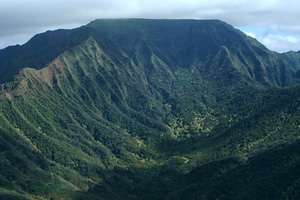 Plateau at the summit of Mount Kaʻala | |
| Highest point | |
| Elevation | 4,025 ft (1,227 m) [1] |
| Prominence | 4,025 ft (1,227 m) |
| Coordinates | 21°30′25″N 158°08′34″W [2] |
| Naming | |
| Language of name | Hawaiian |
| Pronunciation | Hawaiian pronunciation: [kəˈʔɐlə] |
| Geography | |
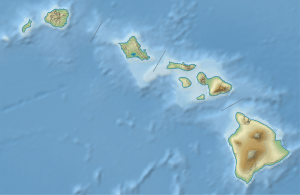 Kaʻala Hawaiian Islands | |
| Location | Oahu, Hawaii, US |
| Parent range | Waianae Range |
| Topo map | USGS Haleiwa |
| Geology | |
| Age of rock | 3.9 Ma |
| Mountain type | Plateau |
| Volcanic arc/belt | Hawaiian-Emperor seamount chain |
See also
- List of mountain peaks of the United States
- List of volcanoes of the United States
- Evolution of Hawaiian volcanoes
- Hawaii hotspot
- Hawaiian–Emperor seamount chain
References
- "Mt. Mount Ka'ala". Department of Forestry and Wildlife. State of Hawaii. Retrieved 2013-02-21.
- "Ka'ala". Geographic Names Information System. United States Geological Survey. Retrieved 2009-12-23.
External links
This article is issued from Wikipedia. The text is licensed under Creative Commons - Attribution - Sharealike. Additional terms may apply for the media files.