K-143 (Kansas highway)
K-143 is a 4.658-mile-long (7.496 km) north–south state highway in Saline County, Kansas. The route runs through lands mostly used for agriculture from an interchange at Interstate 70 (I-70) and U.S. Route 40 (US-40) in northern Salina, Kansas generally northward to a junction with US-81 north of Salina. The southern part of the route is a four-lane divided highway while the rest is a two-lane highway. It has an annual average daily traffic (AADT) between 1,580 and 4,133 vehicles. The route is paved with three different pavement types, and is not a part of the National Highway System. It was first designated as US-81 Alternate in the early 1970s with the designation being changed to K-143 in the early 1980s.
| ||||
|---|---|---|---|---|
%26groups%3D_1da28259ef9c93e1ba16ee446597faf1bb257c0e.svg)
K-143 highlighted in red | ||||
| Route information | ||||
| Maintained by KDOT | ||||
| Length | 4.658 mi (7.496 km) | |||
| Major junctions | ||||
| South end | ||||
| North end | ||||
| Location | ||||
| Counties | Saline | |||
| Highway system | ||||
| ||||

Route description
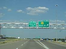
K-143 begins at an interchange with Interstate 70 in the northernmost parts of Salina, Kansas.[1] For the first 0.9 miles (1.4 km) of the route, the highway travels due north through commercial and agricultural land within the Salina city limits.[1][2][3] A short distance after this, K-143 transitions from a divided four-lane highway into a two-lane highway.[1] It then crosses the Saline River and continues north through primarily agricultural land north of Salina.[2][3] At 2.7 miles (4.3 km), K-143 turns northwest and follows a gently curving path in that direction for the remainder of the route,[2][3] ending at an interchange with US-81.[1]
K-143 has an AADT of 4,133 vehicles in the southernmost 0.9 miles (1.4 km) of the route, with an AADT of 1,580–1,595 vehicles in the remainder of the route.[1] The route is paved with a combination of full-design bituminous pavement, composite pavement, and partial-design bituminous pavement.[1] K-143 is not a part of the National Highway System.[4]
History
K-143's route was established between 1970 and 1971 as US-81 Alternate.[5][6] The numbering was changed to K-143 between 1981 and 1983.[7][8]
Major intersections
The entire route is in Saline County.
| Location | mi[1] | km | Destinations | Notes | |
|---|---|---|---|---|---|
| Salina | 0.000 | 0.000 | Southern terminus; I-70 exit 252; diamond interchange | ||
| | 4.658 | 7.496 | Northern terminus; diamond interchange | ||
| 1.000 mi = 1.609 km; 1.000 km = 0.621 mi | |||||
References
- Staff. "Pavement Management Information System Query". Kansas Department of Transportation. Retrieved November 3, 2011.
- Saline County, Kansas Existing Land Use map (PDF). Saline County, Kansas. 2008. Retrieved November 3, 2011.
- Google (November 3, 2011). "Google Map with K-143 highlighted" (Map). Google Maps. Google. Retrieved November 3, 2011.
- National Highway System (PDF) (Map). Kansas Department of Transportation. 2008. Retrieved November 3, 2011.
- Kansas Official Highway Map (PDF) (Map) (1970 ed.). State Highway Commission of Kansas. 1969. § C8. Retrieved November 3, 2011.
- Kansas Official Highway Map (PDF) (Map) (1971 ed.). State Highway Commission of Kansas. 1970. § C8. Retrieved November 3, 2011.
- Kansas Official Highway Map (PDF) (Map) (1981–1982 ed.). Kansas Department of Transportation. 1980. § C8. Retrieved November 3, 2011.
- General Highway Map Saline County, Kansas (PDF) (Map) (1983 ed.). Kansas Department of Transportation Bureau of Transportation Planning. 1983. Retrieved November 3, 2011.