K-13 (Kansas highway)
K-13 is a 14.62-mile-long (23.53 km) state highway in the northeastern part of the US state of Kansas. It begins at U.S. Route 24 (US-24) north of Manhattan and runs north to K-16. K-13 serves as the only northeasterly route out of Manhattan. The majority of the highway is exclusively in Pottawatomie County, with less than a mile of it existing in Riley County. The first two miles (3.2 km) traverse Tuttle Creek State Park, and crosses the Tuttle Creek Lake dam.
| ||||
|---|---|---|---|---|
%26groups%3D_881aa7f7a49f530530135c744a74ffc151d464b6.svg)
K-13 highlighted in red | ||||
| Route information | ||||
| Maintained by KDOT | ||||
| Length | 14.617 mi (23.524 km) | |||
| Existed | 1927[1]–present | |||
| Major junctions | ||||
| South end | ||||
| North end | ||||
| Location | ||||
| Counties | Riley, Pottawatomie | |||
| Highway system | ||||
| ||||

K-13 was first designated as a state highway in 1927 and at that time ran from US-77 in De Graff northward to Manhattan. By 1932, K-13 was realigned to intersect US-77 further south in El Dorado. By 1933, K-13 was extended north from Manhattan to K-9 north of Barrett. In 1958, K-13 was rerouted to cross the Tuttle Creek Dam and continue northward to K-16 southwest of Odessa. Then in 1964, K-13's southern terminus was truncated to Manhattan, and the old section along with K-213 was redesignated as K-177. In 1991, K-13 was truncated to its current southern terminus.
Route description
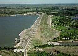
K-13 begins at US-24 north of Manhattan and begins travelling northward. It then curves to the northeast and begins to cross the Tuttle Creek Dam. About halfway across the dam the route enters into Pottawatomie County. The highway soon crosses Cedar Creek, then turns north and begins to parallel the creek. It continues north for two miles (3.2 km) then turns northeast at a junction with Carnahan Road (RS-1208), which goes north to Olsburg. From here it continues along the creek for another two miles (3.2 km) then turns north again, as it crosses Mud Creek. It continues northward for about six miles (9.7 km) then intersects Westmoreland Road (RS-539), which goes east to Westmoreland. Then .5 miles (0.80 km) past here, K-13 reaches its northern terminus at K-16 south of Fostoria.[2]
The Kansas Department of Transportation (KDOT) tracks the traffic levels on its highways, and in 2018, they determined that on average the traffic varied from 1320 vehicles near the northern terminus to 2550 vehicles near the southern terminus.[3][4] K-13 is not included in the National Highway System,[5] a system of highways important to the nation's defense, economy, and mobility.[6] K-13 does connect to the National Highway System at its southern terminus at US-24.[5]
History
K-13 was first designated as a state highway in 1927 by KDOT. At that time it began at US-77 in De Graff, and ran northeastward to Matfield Green, where it turned north. It then reached Cottonwood Falls where it began an overlap with K-57. The two routes continued north to Council Grove, where they began to overlap K-4 for a short distance. Then further north in Dwight, the overlap with K-57 ended and one with K-10 began. K-13 continued north to Alta Vista, where the overlap with K-4 ended. It then continued north and ended in Manhattan.[1] Between 1931 and 1932, K-13 was realigned to go from Matfield Green southwest to US-77 in El Dorado, which bypassed De Graff.[7][8] By 1933, K-13 was extended north from Manhattan along the west side of the Big Blue River. It then turned northeast, crossed the river, and entered Garrison. From here it went northeast before ending at K-9 north of Barrett.[8][9] By 1936, K-113 was established from K-13 west of Bigelow north to Blue Rapids.[9][10] Then on January 14, 1957, K-213 was established from where K-13 crossed the Big Blue River north to Randolph.[11]
Then in a November 19, 1958 resolution, K-13 was rerouted to cross the Tuttle Creek Dam and continue northward to end at K-16 southwest of Odessa. Also at this time, K-113 was decommissioned.[12] In an April 8, 1964 resolution, K-13's southern terminus was truncated to Manhattan. At this time the section of K-13 from El Dorado to K-213, along with K-213 was redesignated as K-177.[13] In a January 1, 1991 resolution, K-13 was truncated to US-24 north of Manhattan. Also, K-177, which overlapped K-13 from Manhattan was truncated to the southeast side of Manhattan.[14]
Major junctions
| County | Location | mi[15][16] | km | Destinations | Notes |
|---|---|---|---|---|---|
| Riley | | 0.000 | 0.000 | Southern terminus; road continues as Dam Road | |
| Tuttle Creek Lake | 0.4– 1.8 | 0.64– 2.9 | Tuttle Creek Dam | ||
| Pottawatomie | | 14.617 | 23.524 | Northern terminus; road continues as K-16 east | |
| 1.000 mi = 1.609 km; 1.000 km = 0.621 mi | |||||
References
- National Map Company (1927). "Kansas" (Map). Sectional paved road map. 1:1,600,000. Indianapolis: National Map Company. pp. 18–19. OCLC 4048012 – via Rumsey Collection.
- "Overview map of K-13". bing.com/maps. Retrieved April 20, 2020.
- Bureau of Transportation Planning (2018). Traffic Flow Map Kansas State Highway System (PDF) (Map). [c. 1:1,584,000]. Topeka: Kansas Department of Transportation. Retrieved April 20, 2020.
- Bureau of Transportation Planning (2018). Traffic Flow Inset Map Kansas State Highway System (PDF) (Map). [c. 1:1,584,000]. Topeka: Kansas Department of Transportation. Retrieved April 20, 2020.
- Federal Highway Administration (May 8, 2019). National Highway System: Kansas (PDF) (Map). Scale not given. Washington, DC: Federal Highway Administration. Retrieved April 20, 2020.
- Natzke, Stefan; Neathery, Mike; Adderly, Kevin (September 26, 2012). "What is the National Highway System?". National Highway System. Federal Highway Administration. Retrieved April 20, 2020.
- Rand McNally and Company (1931). "Kansas" (Map). Clason's Road Map of Kansas. 1:2,000,000. Denver: Clason Map Company. p. 87 – via Rumsey Collection.
- State Highway Commission of Kansas (1932). Kansas State Highway System (PDF) (Map). Scale not given. Topeka: State Highway Commission of Kansas. OCLC 1007837202. Retrieved April 20, 2020.
- State Highway Commission of Kansas (1933). Kansas State Highway System (PDF) (Map). Scale not given. Topeka: State Highway Commission of Kansas. Retrieved April 20, 2020.
- State Highway Commission of Kansas (1936). Kansas State Highway System (Map). Scale not given. Topeka: State Highway Commission of Kansas. Retrieved April 20, 2020.
- State Highway Commission of Kansas (January 14, 1957). "Resolution for addition to state highway system Riley County". Topeka: State Highway Commission of Kansas. Retrieved April 21, 2020.
- State Highway Commission of Kansas (November 19, 1958). "Resolution for relocation and redesegnation of road in Riley County, Pottawatomie County". Topeka: State Highway Commission of Kansas. Retrieved April 8, 2020.
- State Highway Commission of Kansas (April 8, 1964). "Resolution for renumbering of highways K-13 and K-213 from El Dorado to Randolph as K-177". Topeka: State Highway Commission of Kansas. Retrieved April 21, 2020.
- Kansas Department of Transportation (January 21, 1991). "Resolution to remove a segment of highway route designated K-13 and K-177 in Riley County". Topeka: Kansas Department of Transportation. Retrieved April 8, 2020.
- Staff (2014). "Pavement Management Information System". Kansas Department of Transportation. Retrieved March 2, 2015.
- "Overview of K-13". Google Maps. Google, Inc. Retrieved May 18, 2017.