Kütralkura
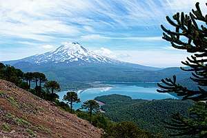
Kütralkura (Spanish: Geoparque Kütralkura, from Mapudungun kütral, fire, and kura, stone, meaning "firestone"[1]) is a geopark in southern Chile's Araucanía Region. The geopark has an area of 8100 km2 and lies mostly in the Andes. It spans four communes: Curacautín, Lonquimay, Melipeuco and Vilcún. All of Conguillio National Park and Llaima, one of Chile's most active volcanoes, lie within the geopark.[2]
2019, Kütralkura was being considered for inclusion in the Global Geoparks Network.[3][4] The inclusion in the netwrok was confirmed and accepted on April 17, 2019, by UNESCO’s Executive Board.[1] The original geopark project was carried out and supported by the National Geology and Mining Service and CORFO.[4]
The work done at Kütralkura is being used as template for a similar initiative in Palena Province.[3]
References
- "Eleven sites and extensions in Asia, Europe, and South America receive UNESCO Global Geopark Label". unesco.org. UNESCO. April 17, 2019. Retrieved April 21, 2019.
- "Geoparque Kütralkura: la apuesta de Chile por preservar su patrimonio geológico". El Espectador (in Spanish). November 7, 2018. Retrieved November 12, 2018.
- "Operadores turísticos del territorio Patagonia Verde valoran gira al Geoparque Kütralkura en la Región de La Araucanía". Diario Lawen (in Spanish). May 17, 2018. Retrieved October 30, 2018.
- "Postulación de Geoparque Kütralkura a Red Global de UNESCO fue presentada ante Concejo Municipal de Vilcún". Vilcun.cl (in Spanish). August 9, 2018. Retrieved October 30, 2018.