Joinville Island
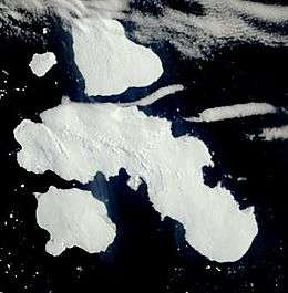
Joinville Island is the largest island of the Joinville Island group, about 40 nmi (74 kilometres) long in an east-west direction and 12 nmi (22 kilometres) wide, lying off the northeastern tip of the Antarctic Peninsula, from which it is separated by the Antarctic Sound. Joinville Island was discovered and charted roughly during 1838 by a French expedition commanded by Captain Jules Dumont d'Urville, who named it for Prince François, Prince of Joinville (1818–1900), the third son of Louis-Philippe, Duke of Orléans.[1] It is within the Argentine, British and Chilean Antarctic claims.
 | |
 Joinville Island | |
| Geography | |
|---|---|
| Location | Antarctica |
| Coordinates | 63°15′S 55°45′W |
| Archipelago | Joinville Island group |
| Area | 1,607 km2 (620 sq mi) |
| Length | 74 km (46 mi) |
| Width | 22 km (13.7 mi) |
| Administration | |
| Administered under the Antarctic Treaty System | |
| Demographics | |
| Population | 0 |
Geography
Joinville Island consists of a series of valleys and bays, including Suspiros Bay and Balaena Valley.
See also
- Composite Antarctic Gazetteer
- List of Antarctic and sub-Antarctic islands
- List of Antarctic islands south of 60° S
- SCAR
- Territorial claims in Antarctica
References
- "Joinville Island". Geographic Names Information System. United States Geological Survey. Retrieved 2004-11-03.
External links
This article is issued from Wikipedia. The text is licensed under Creative Commons - Attribution - Sharealike. Additional terms may apply for the media files.