Jim Woodruff Dam
Jim Woodruff Dam is a hydroelectric dam on the Apalachicola River, about 1,000 feet (300 m) south of that river's origin at the confluence of the Flint and Chattahoochee Rivers.
| Jim Woodruff Dam | |
|---|---|
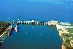 Aerial view of Jim Woodruff Dam in 1999 (by U.S. Army Corps of Engineers) | |
| Official name | Jim Woodruff Dam |
| Location | Gadsden and Jackson counties, Florida / Decatur County, Georgia, USA |
| Coordinates | 30°42′31″N 84°51′51″W |
| Construction began | about 1947 |
| Opening date | 1957 |
| Operator(s) | U.S. Army Corps of Engineers |
| Dam and spillways | |
| Impounds | Chattahoochee, and Flint Rivers |
| Reservoir | |
| Creates | Lake Seminole |
| Surface area | 58.6 square miles (152 km2) |
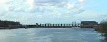
The dam, photographed from US90
The dam impounds Lake Seminole on the common border of Florida and Georgia. The dam is named in honor of James W. Woodruff, Sr., a Georgia businessman who spearheaded the development of the Apalachicola-Chattahoochee-Flint Project.[1][2]
References
- "The Jim Woodruff Dam Near Chattahoochee, Florida". www.anniemayhem.com. Retrieved 2020-03-20.
- "Earth Snapshot • Jim Woodruff Lock and Dam". www.eosnap.com. Retrieved 2020-03-20.
This article is issued from Wikipedia. The text is licensed under Creative Commons - Attribution - Sharealike. Additional terms may apply for the media files.