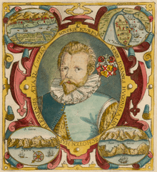
Jan Huyghen van Linschoten
Jan Huyghen van Linschoten (1563 – 8 February 1611) was a Dutch merchant, trader and historian. An alternative (modern Dutch) spelling of his second name is Huijgen.
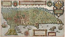
He travelled extensively along the East Indies' regions under Portuguese influence and served as the archbishop's secretary in Goa between 1583 and 1588. He is credited with publishing in Europe important classified information about Asian trade and navigation that was hidden by the Portuguese. In 1596 he published a book, Itinerario (later published as an English edition as Discours of Voyages into Ye East & West Indies) which graphically displayed for the first time in Europe detailed maps of voyages to the East Indies, particularly India. During his stay in Goa, abusing the trust put in him by his employer, Jan Huyghens meticulously copied the top-secret charts page-by-page. Even more crucially, Jan Huyghens provided nautical data like currents, deeps, islands and sandbanks, which was absolutely vital for safe navigation, along with coastal depictions to guide the way. The publication of the navigational routes enabled the passage to the East Indies to be opened to trading by the Dutch, French and the English. As a consequence, The Dutch East India Company and British East India Company would break the 16th-century monopoly enjoyed by the Portuguese on trade with the East Indies.
Origins
Jan Huyghen was born in Haarlem in Holland, the son of a public notary and his wife. The family moved to the town of Enkhuizen when he was young. The addition of van Linschoten could indicate that his family had origins in the Utrecht village of the same name.[1]
Early life
Huyghen left for Spain during December 1576 to live with his older brother Willem, who was working as a merchant in Seville. He learned Spanish and worked there until 1580, when he got a job in Lisbon, Portugal, working with another merchant. A downturn in trade led him to seek alternatives. With the help of Willem, who was acquainted with the newly appointed Archbishop of the Portuguese colony of Goa, Dominican Vicente da Fonseca, the younger Huyghen was appointed Secretary to the Archbishop. Huyghen sailed for Goa on 8 April 1583, arriving five months later via Madeira, Guinea, the Cape, Madagascar and Mozambique.
Goa
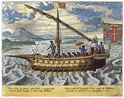
While in Goa, Jan Huygen kept a diary of his observations of the Portuguese-ruled city, amassing information about the Europeans, Indians, and other Asians who lived there. He also had access to maps and other privileged information about commerce and Portuguese navigation in southeast Asia and used his cartographic and drawing skills in order to copy and draw new maps, reproducing a considerable amount of nautical and mercantile information. Several of the nautical charts that he copied had been meticulously kept secret by the Portuguese for more than a century.
Later after returning to Enkhuizen, he collected accounts from other travelers, such as Dirck "China" Gerritsz, a fellow resident of Enkhuizen who earned his nickname from his travels in the Far East. Jan Huygen made note of the trading conditions among different countries, and the sea routes for travelling between them. This information later helped both the Dutch and the English to challenge the Portuguese monopoly on East Indian trade.
The 1587 death of his sponsor, the Archbishop of Goa, while on a trip to Lisbon to report to the King of Portugal, meant the end of the Huyghens' appointment. He set sail for Lisbon in January 1589, passing by the Portuguese supply depot at St. Helena Island in May 1589.
The Azores
The voyage was interrupted by English piracy which forced a shipwreck. Huyghen spent two years in the Azores. He did not reach Lisbon until 1592, returning to his home city of Enkhuizen.
Barentsz First voyage
In June 1594, Huyghen (now recorded as Linschoten) sailed from Texel in the expedition headed by Dutch cartographer Willem Barentsz. The fleet of three ships was to enter the Kara Sea, with the hopes of finding the Northeast passage above Siberia.[2] At Williams Island the crew encountered a polar bear for the first time. They managed to bring it on board, but the bear rampaged and was killed. Barentsz reached the west coast of Novaya Zemlya and followed it northward, before being forced to turn back in the face of large icebergs.
Barentsz Second voyage
.jpg)
The following year they sailed again in a new expedition of six ships, loaded with merchant wares that they hoped to trade with China.[3] The party came across Samoyed "wild men" but eventually had to turn back when discovering the Kara Sea to be frozen. Linschoten was one of the two crew members to publish journals about the Barentsz expedition.
Return to Holland
In 1595, with assistance from Amsterdam publisher Cornelis Claesz, who specialised in shipping, geography and travels, Jan Huyghens wrote Reys-gheschrift vande navigatien der Portugaloysers in Orienten (Travel Accounts of Portuguese Navigation in the Orient). This work contains numerous sailing directions, not only for shipping between Portugal and the East Indies colonies, but also between India, China and Japan.[4] It also contains one of the earliest European accounts of tea drinking in Japan:
"Their manner of eating and drinking is: everie man hath a table alone, without table-clothes or napkins, and eateth with two pieces of wood like the men Chino: they drink wine of Rice, wherewith they drink themselves drunke, and after their meat they use a certain drinke, which is a pot with hote water, which they drink as hot as ever they may indure, whether it be Winter or Summer... The aforesaid warme water is made with the powder of a certaine hearbe called Chaa, which is much esteemed, and is well accounted among them."[5]
In the same year, 1595, he married Reynu Meynertsdr. Seymens of Enkhuizen. She was "already four months pregnant by her intended second husband....At the time of her courtship Reynu Seymens was thirty-one and a mother of three. Her lover's voyaging career may well have hastened their consummation."[4]
Jan Huyghen also wrote two other books, Beschryvinghe van de gantsche custe van Guinea, Manicongo, Angola ende tegen over de Cabo de S. Augustijn in Brasilien, de eyghenschappen des gheheelen Oceanische Zees (Description of the Entire Coast of Guinea, Manicongo, Angola and across to the Cabo de St. Augustus in Brazil, the Characteristics of the Entire Atlantic Ocean), published in 1597; and Itinerario: Voyage ofte schipvaert van Jan Huyghen van Linschoten naer Oost ofte Portugaels Indien, 1579-1592 (Travel account of the voyage of the sailor Jan Huyghen van Linschoten to the Portuguese East India), published in 1596. "The frontispiece of the first edition [was] pirated [from] the engraving from (of all things) a work celebrating the campaigns of a Spanish general and printed...up as the Dutch hero" by his publisher Joost Gillis Saeghman.[6] The map published in this book, Exacta & accurata delinatio… regionibus China, Cauchinchina, Camboja, sive Champa, Syao, Malacca, Arracan & Pegu, was prepared by Petrus Plancius.[7]
An English-language edition of the Itinerario was published in London in 1598, entitled Iohn Huighen van Linschoten his Discours of Voyages into ye Easte & West Indies. A German edition was printed the same year. Considered very significant, it was published in Latin in Frankfurt, 1599; another Latin translation in Amsterdam, 1599; and in French in 1610.[8]
In addition to detailed maps of these places, Linschoten also provided the geographic ‘key’ to unlocking the Portuguese grip on passage through the Malacca Strait. He suggested traders approach the East Indies from the south of Sumatra through the Sunda Strait, thereby minimizing the risk of Portuguese intervention. This passage eventually became the main Dutch route into southeast Asia and was at the origin of their colonization of the territories that form today's Indonesia.
Linschoten died in Enkhuizen where he had acted as Treasurer to the town.[9]
Legacy and honors
- The Linschoten Society was founded in 1908 to publish rare or unpublished Dutch travel accounts of voyages, journeys by land, and descriptions of countries. It is based in the 21st century at the Amsterdam Ship Museum.
- ABN-AMRO bank of The Netherlands established the Jan Huyghen van Linschoten Award in his honor, a business excellence award. In 2007 it was awarded to the Netherlands-based creative firm OMA for its success in entering and maintaining business in emerging markets such as China, Kazakhstan, and the United Arab Emirates.
- The minor planet 10651 van Linschoten is named after him.
Editions
- 1598 English translation, John Huighen van Linschoten, His discours of voyages into ye Easte and West Indies: deuided into foure bookes London: John Wolfe. online. In Wolfe's ordering, the First Book is the 1596 Itinerario, Second Book is 1597 Beschryvinghe, Third Book is the 1595 Reys-gheschrift and the Fourth Book is Linschoten's translation of the revenues of the Spanish crown. In other editions, the 2nd and 3rd books are often switched around.
- 1598 John Huighen van Linschoten his Discours of Voyages into ye Easte & West Indies From the Collections at the Library of Congress
- 1874–85 English edition, The Voyage of John Huyghen van Linschoten to the East Indies, 1874–85 edition, London: Hakluyt. Reprint of only the First Book of 1598 translation ( vol. 1, vol. 2)
References
- "Archived copy". Archived from the original on 2 November 2005. Retrieved 16 September 2005.CS1 maint: archived copy as title (link)
- Synge 1912, p. 258
- ULT 2009, web
- Simon Schama, The Embarrassment of Riches: An Interpretation of Dutch Culture in the Golden Age. New York: Vintage Books, 1987, p. 438.
- 'The World of Caffeine: The Science and Culture of the World's Most Popular Drug', by Bennett Alan Weinberg and Bonnie K. Bealer, p. 63
- Schama, p. 28.
- Leo Bagrow, History of Cartography, revised and enlarged by R. A. Skelton, London, Watts, 1964, p. 265. Exacta & accurata delinatio cum orarum maritimarum tum etiam locorum terrestrium quæ in regionibus China, Cauchinchina, Camboja, sive Champa, Syao, Malacca, Arracan & Pegu; Cornelis Koeman, Jan Huygen Van Linschoten, Coimbra, Universidade de Coimbra Biblioteca Geral 1, 1984, Centro de Estudos de Historia e Cartografia, Vol. 153, pp. 39–41. Also in Revista da Universidade de Coimbra, vol. 32, 1985, pp. 27–47.
- For a list of the various editions, see Koeman (1985: pp. 41ff.)
- de Veer, Gerrit (1853). A True Description of Three Voyages by the North-east Towards Cathay and China: Undertaken by the Dutch in the Years 1594, 1595 and 1596. Hakluyt Society. p. 40.
Further reading
- Burnell, Arthur Coke; Tiele, P.A (1885), The voyage of John Huyghen van Linschoten to the East Indies, from the old English translation of 1598: the first book, containing his description of the East, London: The Hakluyt Society. Full text at Internet Archive.
- Van Linschoten; Jan Huyghen (2005), The Voyage of John Huyghen van Linschoten to the East Indies, Elibron Classics, the Hakluyt Society, ISBN 1-4021-9507-9
- Van Linschoten, Jan Huyghen. Voyage to Goa and Back, 1583–1592, with His Account of the East Indies : From Linschoten's Discourse of Voyages, in 1598/Jan Huyghen Van Linschoten. Reprint. New Delhi, AES, 2004, xxiv, 126 p. ISBN 81-206-1928-5.
- Synge, J.B. (1912). A Book of Discovery. Yesterday's Classics. ISBN 1-59915-192-8.
- "Willem Barentsz and the Northeast passage". University Library of Tromsø – The Northern Lights Route. Retrieved 18 June 2010.
- Koeman, C. (1985) "Jan Huygen van Linschoten", Revista da Universidade de Coimbra, Vol. 32, pp. 27–47. offprint
External links

| Authority control |
|
|---|