Isandlwana
Isandlwana (Zulu pronunciation: [ísanˈdɮwáːna])[2] (older spelling Isandhlwana, also sometimes seen as Isandula) is an isolated hill in the KwaZulu-Natal province of South Africa. It is located 169 kilometres (105 mi) north by northwest of Durban.[3] The name is said to mean abomasum, the second stomach of the cow, because it reminded the Zulus of its shape.
| Isandlwana | |
|---|---|
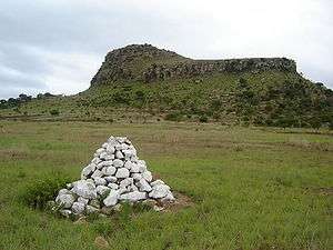 Isandlwana with a British cairn marking a grave from the Battle of Isandlwana | |
| Highest point | |
| Elevation | 1,284 m (4,213 ft) [1] |
| Listing | List of mountains in South Africa |
| Coordinates | 28°21′7″S 30°39′6″E |
| Geography | |
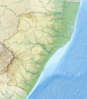 Isandlwana Location in KwaZulu-Natal | |
| Location | KwaZulu-Natal |
| Parent range | Drakensberg foothill |
| Climbing | |
| First ascent | Unknown |
| Easiest route | From Dundee |
History
This mountain has historical significance. On 22 January 1879, Isandlwana was the site of the Battle of Isandlwana, where approximately 22,000 Zulu warriors defeated a contingent of approximately 1,350 British and Native troops in one of the first engagements of the Anglo-Zulu War.[4] The force was largely wiped out by the Zulus under Ntshingwayo kaMahole Khoza. The battle remains the single greatest defeat for the British Army at the hands of a native army.[5]
Isandlwana hill rises 16 kilometres (10 mi) Northeast of Rorke's Drift, a ford on the Buffalo River, a tributary of the Tugela River.
See also
- Battle of Isandlwana
- List of mountains in South Africa
- SAS Isandlwana (F146) - a Valour-class frigate of the South African Navy
References
- Google Earth
- John Wells: the symbol ɮ. John Wells’s phonetic blog, 19. September 2012.
- Encyclopædia Britannica (1950), v.12, 703.
- BritishBattles.com "The Battle of Isandlwana"
- The Battle of Isandlwana