Isabel II barrio-pueblo
Isabel II barrio-pueblo (referred to as Isabel Segunda in Spanish) is a barrio and the administrative center (seat) in the downtown area in the island-municipality of Vieques, Puerto Rico. Its population in 2010 was 1,354.[1][2][3]
Isabel II barrio-pueblo Barrio Pueblo Isabel Isabel Segunda | |
|---|---|
Municipality Seat | |
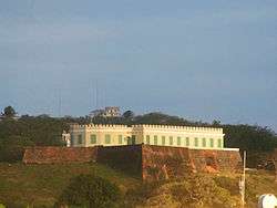 El Fortín Conde de Mirasol | |
| Commonwealth | |
| Municipality | |
| Area | |
| • Total | .50 sq mi (1.3 km2) |
| • Land | .36 sq mi (0.9 km2) |
| • Water | .14 sq mi (0.4 km2) |
| Population (2010) | |
| • Total | 1,207 |
| Source: 2010 Census | |
| Time zone | UTC−4 (AST) |
History
The United States took control of Puerto Rico from Spain in the aftermath of the Spanish-American War under the terms of the Treaty of Paris of 1898. In 1899, the United States conducted its first census of Puerto Rico, finding that the combined population of Pueblo and Florida barrios was 2,646.[4]
Historic sites
It is the location of several historic sites listed on the U.S. National Register of Historic Places, including:
- Fuerte de Vieques (El Fortín Conde de Mirasol)
- Casa Alcaldia de Vieques
- Casa Augusto Delerme
- Casa Delerme-Anduze No. 2
- Casa de Jaime Puig Lemoine
- Delerme-Anduze House
- Las Tumbas de J. J. Maria le Guillou
- Rafael Acevedo House
- Smaine-Ortiz House
The central plaza
As was customary in Spain, in Puerto Rico, the municipality has a barrio called pueblo which contains a central plaza, the municipal buildings (city hall), and a Catholic church. Fiestas patronales (patron saint festivals) are held in the central plaza every year.[5][6]
The central plaza, or square, is a place for official and unofficial recreational events and a place where people can gather and socialize from dusk to dawn. The Laws of the Indies, Spanish law, which regulated life in Puerto Rico in the early 19th century, stated the plaza's purpose was for "the parties" (celebrations, festivities) (Spanish: a propósito para las fiestas), and that the square should be proportionally large enough for the number of neighbors (Spanish: grandeza proporcionada al número de vecinos). These Spanish regulations also stated that the streets nearby should be comfortable portals for passersby, protecting them from the elements: sun and rain.[5]
Sectors
Barrios (which are like minor civil divisions)[7] in turn are further subdivided into smaller local populated place areas/units called sectores (sectors in English). The types of sectores may vary, from normally sector to urbanización to reparto to barriada to residencial, among others.[8][9][10]
The following sectors are in Isabel II barrio-pueblo: Barriada Fuerte, Calle Antonio G. Mellado, Calle Baldorioty de Castro, Calle Benítez Castaño, Calle Carlos Lebrum, Calle Muñoz Rivera, Calle Plinio Peterson, Calle Prudencio Quiñones, Calle Tomás Pérez Brignoni, Calle Víctor Duteill, Calle 65 de Infantería, Condominio Terra San Francisco, Sector Buena Vista, Sector Cañón, Sector Leguillow, and Sector Pueblo Nuevo.[11]
Gallery
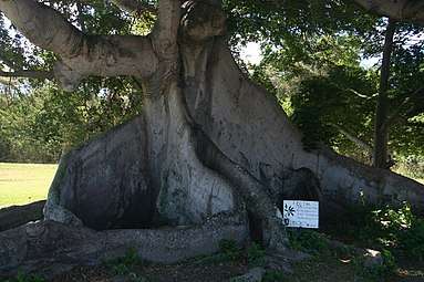 300-year-old Ceiba Tree in Isabel II
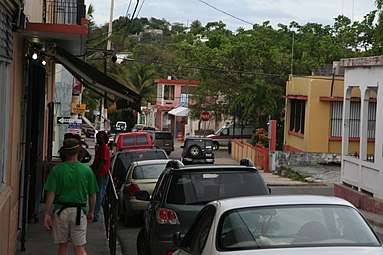 Street in Isabel II barrio-pueblo
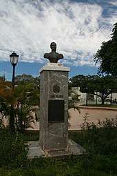 Statue of Simon Bolivar in Isabel II
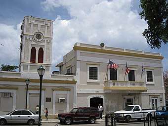 The City Hall in Isabel II barrio-pueblo
See also
References
- Picó, Rafael; Buitrago de Santiago, Zayda; Berrios, Hector H. Nueva geografía de Puerto Rico: física, económica, y social, por Rafael Picó. Con la colaboración de Zayda Buitrago de Santiago y Héctor H. Berrios. San Juan Editorial Universitaria, Universidad de Puerto Rico,1969.
- Gwillim Law (20 May 2015). Administrative Subdivisions of Countries: A Comprehensive World Reference, 1900 through 1998. McFarland. p. 300. ISBN 978-1-4766-0447-3. Retrieved 25 December 2018.
- Puerto Rico:2010:population and housing unit counts.pdf (PDF). U.S. Dept. of Commerce, Economics and Statistics Administration, U.S. Census Bureau. 2010.
- Joseph Prentiss Sanger; Henry Gannett; Walter Francis Willcox (1900). Informe sobre el censo de Puerto Rico, 1899, United States. War Dept. Porto Rico Census Office (in Spanish). Imprenta del gobierno. p. 164.
- Santullano, Luis A. (10 March 2019). Mirada al Caribe. 54. Colegio de Mexico. pp. 75–78. doi:10.2307/j.ctvbcd2vs.12. JSTOR j.ctvbcd2vs.12.
- Pariser, Harry S. (2003). Explore Puerto Rico, Fifth Edition. San Francisco: Manatee Press. pp. 52–55. Retrieved 10 February 2019.
- "US Census Barrio-Pueblo definition". factfinder.com. US Census. Archived from the original on 13 May 2017. Retrieved 5 January 2019.
- "Agencia: Oficina del Coordinador General para el Financiamiento Socioeconómico y la Autogestión (Proposed 2016 Budget)". Puerto Rico Budgets (in Spanish). Retrieved 28 June 2019.
- Rivera Quintero, Marcia (2014), El vuelo de la esperanza: Proyecto de las Comunidades Especiales Puerto Rico, 1997-2004 (first ed.), San Juan, Puerto Rico Fundación Sila M. Calderón, ISBN 978-0-9820806-1-0
- "Leyes del 2001". Lex Juris Puerto Rico (in Spanish). Retrieved 24 June 2020.
- "PRECINTO ELECTORAL VIEQUES 096" (PDF). Comisión Estatal de Elecciones (in Spanish). PR Government. 8 October 2019. Retrieved 24 June 2020.