Inverie Bay
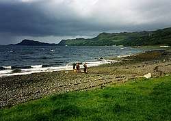
Inverie Bay is a coastal embayment, on a chord of 2.12 miles, on a 207° orientation, on the northwestern coast of the sea loch in Loch Nevis, and is next to the village that takes its name, Inverie, within the Knoydart peninsula.[2]
| Inverie Bay | |
|---|---|
 Inverie Bay | |
 Inverie Bay | |
| Location | NM 7635 9948 |
| Coordinates | 57.0321°N 5.68734808°W |
| Type | sea loch bay |
| River sources | Inverie river, |
| Ocean/sea sources | Atlantic Ocean |
| Islands | Inverie River.[1] |
Geography
Glen Meadail is clearly visible from Inverie Bay, on the right side of the bay.
References
- Bruce Sandison (20 June 2013). Rivers and Lochs of Scotland 2013/2014 Edition: The Angler's Complete Guide. Black & White Publishing. p. 639. ISBN 978-1-84502-712-4. Retrieved 19 December 2018.
- "Inverie Bay, Highland". Ordnance Survey. Ordnance Survey 2018. Retrieved 19 December 2018.
This article is issued from Wikipedia. The text is licensed under Creative Commons - Attribution - Sharealike. Additional terms may apply for the media files.