Insula (Roman city)
The Latin word insula (literally meaning "island", plural insulae) was used in Roman cities to mean either a city block in a city plan, i.e. a building area surrounded by four streets,[1] or a type of apartment building that occupied such a city block.[2][3]
A standard Roman city plan[4] was based on a grid of orthogonal streets.[5] It was founded on the ancient Greek model of Hippodamus and was used especially when new cities were established, e.g. in Roman coloniae.
The streets of each city were designated the Decumani (east–west-oriented) and Cardines (north–south). The principal streets, the Decumanus Maximus and Cardo Maximus intersected at, or close to, the forum around which the most important public buildings were sited.

Plan of Roman Cologne (Colonia Claudia Ara Agrippinensium)
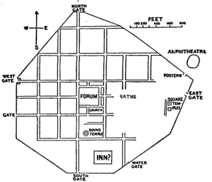
Plan of Silchester
References
- Chaitanya Iyyer (1 December 2009). Land Management. Global India Publications. p. 147. ISBN 978-93-80228-48-8.
- Gregory S. Aldrete (2004). Daily Life in the Roman City: Rome, Pompeii and Ostia. Greenwood Publishing Group. pp. 78–80. ISBN 978-0-313-33174-9.
- Stephen L. Dyson (1 August 2010). Rome: A Living Portrait of an Ancient City. JHU Press. pp. 217–9. ISBN 978-1-4214-0101-0.
- Macaulay, David (1974). City: A Story of Roman Planning and Engineering. Boston: Houghton-Mifflin.
- "Roman Engineers: A Plan for a Small Roman City".
Sources and further reading
- The Insula IX Excavation: http://www.reading.ac.uk/silchester/town-life/insula_ix.php
- Pompeii Insula 9: http://donovanimages.co.nz/proxima-veritati/insula-9/index.html
This article is issued from Wikipedia. The text is licensed under Creative Commons - Attribution - Sharealike. Additional terms may apply for the media files.