Indiana State Road 166
State Road 166 in the U.S. State of Indiana is a short highway in southern Perry County. Though it has an even number, in practice it is a north–south highway for most of its length.
| ||||
|---|---|---|---|---|
 | ||||
| Route information | ||||
| Maintained by INDOT | ||||
| Length | 6.360 mi[1] (10.235 km) | |||
| Major junctions | ||||
| South end | Tobinsport | |||
| North end | ||||
| Location | ||||
| Counties | Perry | |||
| Highway system | ||||
| ||||

Route description
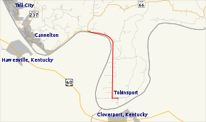
State Road 166 begins at the banks of the Ohio River just south of the small town of Tobinsport. Leaving the town, it heads straight north until the river bends to the west, at which point the road also bends to the west and hugs the banks of the river for a mile or so until it reaches State Road 66.
The highway is narrower than most state-maintained highways, and during times of high water levels on the Ohio River, it is often closed. The road surface is rough and undulating in places, this being caused by it being submerged for a prolonged period of time during the 1997 Ohio River Flood.
Major intersections
The entire route is in Tobin Township, Perry County.
| mi[1] | km | Destinations | Notes | ||
|---|---|---|---|---|---|
| 0.000 | 0.000 | Dead end | Southern terminus of SR 166 | ||
| 6.360 | 10.235 | Northern terminus of SR 166 | |||
| 1.000 mi = 1.609 km; 1.000 km = 0.621 mi | |||||
References
- Indiana Department of Transportation (July 2015). Reference Post Book (PDF). Indianapolis: Indiana Department of Transportation. Retrieved September 27, 2016.