Indiana State Road 154
State Road 154, in the U.S. State of Indiana, is a short two-lane east–west highway located in western Sullivan County.
| ||||
|---|---|---|---|---|
 | ||||
| Route information | ||||
| Maintained by INDOT | ||||
| Length | 13.181 mi[1] (21.213 km) | |||
| Major junctions | ||||
| West end | IL border near Hutsonville, Illinois | |||
| East end | ||||
| Location | ||||
| Counties | Sullivan | |||
| Highway system | ||||
| ||||

Route description
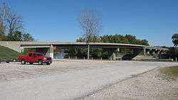
Wabash River bridge
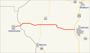
State Road 154 begins at the Wabash River bridge across from Hutsonville, Illinois and runs eastward through Graysville, where it crosses State Road 63. It ends where it meets U.S. Route 41 just west of Sullivan.
Major intersections
| County | Location | mi[1] | km | Destinations | Notes |
|---|---|---|---|---|---|
| Crawford | Hutsonville | 0.000 | 0.000 | Clover Street | Western terminus of SR 154 at the Illinois border |
| Wabash River | 0.008 | 0.013 | |||
| Sullivan | Graysville | 5.728 | 9.218 | ||
| Sullivan | 13.181 | 21.213 | Eastern terminus of SR 154 | ||
| 1.000 mi = 1.609 km; 1.000 km = 0.621 mi | |||||
References
- Indiana Department of Transportation (July 2016). Reference Post Book (PDF). Indianapolis: Indiana Department of Transportation. SR 154. Retrieved January 11, 2017.
This article is issued from Wikipedia. The text is licensed under Creative Commons - Attribution - Sharealike. Additional terms may apply for the media files.