Indian Creek (Guyandotte River tributary)
Indian Creek is a tributary of the Guyandotte River, 19.7 miles (31.7 km) long,[3] in southern West Virginia in the United States. Via the Guyandotte and Ohio rivers, it is part of the watershed of the Mississippi River, draining an area of 43 square miles (110 km2)[4] in a rural area on the unglaciated portion of the Allegheny Plateau.
| Indian Creek | |
|---|---|
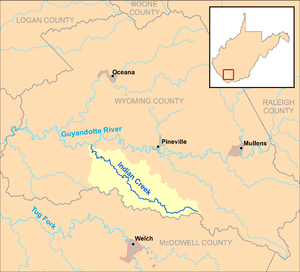 Indian Creek and its watershed in Wyoming County, West Virginia | |
| Location | |
| Country | United States |
| State | West Virginia |
| County | Wyoming |
| Physical characteristics | |
| Source | |
| • location | southeastern Wyoming County |
| • coordinates | 37.4831698°N 81.4584366°W[1] |
| • elevation | 2,315 ft (706 m)[2] |
| Mouth | Guyandotte River |
• location | east of Baileysville |
• coordinates | 37.5870558°N 81.6648324°W[1] |
• elevation | 1,132 ft (345 m)[1] |
| Length | 19.7 mi (31.7 km) |
| Basin size | 43 sq mi (110 km2) |
Indian Creek's entire course and drainage area are in southern Wyoming County. It rises in southeastern Wyoming County, approximately 5 miles (8.0 km) south of New Richmond, and flows generally northwestward, through the unincorporated communities of Wolf Pen, Fanny, and Fanrock. It flows into the Guyandotte River from the south, approximately 0.3 miles (0.48 km) east of Baileysville. A section of the creek's middle course is paralleled by West Virginia Route 16.[5]
According to the West Virginia Department of Environmental Protection, approximately 97.7% of the Indian Creek watershed is forested, mostly deciduous.[4]
See also
References
- Geographic Names Information System. "Geographic Names Information System entry for Indian Creek (Feature ID #1540676)". Retrieved 2013-02-24.
- Google Earth elevation for GNIS source coordinates. Retrieved on 2013-02-24.
- United States Environmental Protection Agency. "Watershed Assessment, Tracking & Environmental Results: Assessment Summary for Reporting Year 2008, West Virginia, Upper Guyandotte Watershed". Archived from the original on 2011-10-15. Retrieved 2013-02-24.
- West Virginia Department of Environmental Protection. "Upper Guyandotte River". Watershed Atlas Project. Archived from the original on 2005-04-05. Retrieved 2013-02-24. External link in
|work=(help) - West Virginia Atlas & Gazetteer. Yarmouth, Me.: DeLorme. 1997. p. 58. ISBN 0-89933-246-3.