Hypsometry
Hypsometry (from Greek ὕψος, hupsos, "height"[1] and μέτρον, metron, "measure"[2]) is the measurement of land elevation (relative to mean sea level).[3] Bathymetry is the underwater equivalent.
On Earth, the elevations can take on either positive or negative (below sea level) values, and are bimodal due to the contrast between the continents and oceans. On other planets within this solar system, elevations are typically unimodal, owing to the lack of oceans on those bodies.

Hypsometric curve
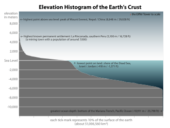
A hypsometric curve is a histogram or cumulative distribution function of elevations in a geographical area. Differences in hypsometric curves between landscapes arise because the geomorphic processes that shape the landscape may be different.
When drawn as a 2-dimensional histogram, a hypsometric curve displays the elevation (y) on the vertical, y-axis and area above the corresponding elevation (x) on the horizontal or x-axis. The curve can also be shown in non-dimensional or standardized form by scaling elevation and area by the maximum values. The non-dimensional hypsometric curve provides a hydrologist or a geomorphologist with a way to assess the similarity of watersheds — and is one of several characteristics used for doing so. The hypsometric integral is a summary measure of the shape of the hypsometric curve.
In the original paper on this topic, Arthur Strahler proposed a curve containing three parameters to fit different hypsometric relations:[4]
- ,

where a, d and z are fitting parameters. Subsequent research using two-dimensional landscape evolution models has called the general applicability of this fit into question,[5] as well as the capability of the hypsometric curve to deal with scale-dependent effects.
See also
- Hypsometric equation
- Hypsometric integral
- Hypsometer, an instrument used in hypsometry, which estimates the elevation by boiling water – water boils at different temperatures depending on the air pressure, and thus altitude.
References
- ὕψος, Henry George Liddell, Robert Scott, A Greek-English Lexicon, on Perseus
- μέτρον, Henry George Liddell, Robert Scott, A Greek-English Lexicon, on Perseus
- "MSN Encarta". Archived from the original on 2009-10-01.
- Strahler, Arthur N. (1952). "Hypsometric (area-altitude) analysis of erosional topography". Bulletin of the Geological Society of America. 63 (11): 1117–1142. doi:10.1130/0016-7606(1952)63[1117:HAAOET]2.0.CO;2.
- Willgoose, G.; Hancock, G. (1998). "Revisiting the hypsometric curve as an indicator of form and process in transport‐limited catchment". Earth Surface Processes and Landforms. 23 (7): 611–623. doi:10.1002/(SICI)1096-9837(199807)23:7<611::AID-ESP872>3.0.CO;2-Y.