Hverfjall
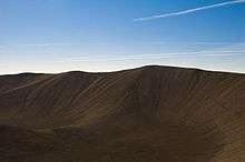
Hverfjall (also known as Hverfell) is a tephra cone or tuff ring volcano in northern Iceland, to the east of Mývatn.
| Hverfjall | |
|---|---|
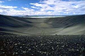 The Hverfjall crater from the south | |
| Highest point | |
| Elevation | 420 m (1,380 ft) |
| Coordinates | 65°36′00″N 16°53′00″W |
| Geography | |
| Location | Iceland |
| Geology | |
| Mountain type | Tephra cone, tuff ring volcano |
| Last eruption | 2500 BP |
It erupted in 2500 BP in the southern part of the Krafla fissure swarm.[1] The crater is approximately 1 km in diameter.[2]
Tephra has been carried from Hverfjall all over the Lake Myvatn area. A landslide apparently occurred in the south part of the crater during the eruption, which accounts for the disruption to the round shape of the mountain. During the Age of Settlement, lava flowed from Svortuborgir, at the southern end of Namafjall, around Hverfjall, which was nearly engulfed by the lava. At the same time an eruption occurred in the slopes above the valley of Hlidardalur.
The rim of the crater is only accessible by two paths, from the northwest and south. It is strictly forbidden to use other routes in ascent or descent.
References
- The Hverfjall fissure eruption Archived 2011-07-28 at the Wayback Machine Accessed 29 October 2008
- Rough Guide on Hverfjall Accessed 29 October 2008
External links
![]()