Hunger stone
A hunger stone (German: Hungerstein) is a type of hydrological landmark common in Central Europe. Hunger stones serve as famine memorials and warnings and were erected in Germany and in ethnic German settlements throughout Europe in the 15th through 19th centuries.
.JPG)
These stones were embedded into a river during droughts to mark the water level as a warning to future generations that they will have to endure famine-related hardships if the water sinks to this level again. One famous example in the Elbe river in Děčín, Czech Republic, has "Wenn du mich siehst, dann weine" (lit. "If you see me, weep") carved into it as a warning.[1]
Many of these stones, featuring carvings or other artwork, were erected following the hunger crisis of 1816–1817 caused by the eruptions of the Tambora volcano.[2]
In 1918, a hunger stone on the bed of the Elbe River, near Tetschen, became exposed during a period of low water coincident to the wartime famines of World War I.[3] Similar hunger stones in the river were uncovered again during a drought in 2018.[4]
Known hunger stones
| River | Location | Notes | Picture |
|---|---|---|---|
| Elbe | Děčín (Tetschen)
left riverbank, near the Tyrs bridge |
The stone measures approximately 6 m³ and is carved with different years of drought. The oldest readable carving is from 1616, with older carvings (1417 and 1473) having been wiped out by anchoring ships during the years. The stone also features the Czech sentence „Neplač holka, nenaříkej, když je sucho, pole stříkej“ (lit. "Girl, don't weep and moan, if it's dry, water the field"), probably added in 1938.[5] This hunger stone is one of the oldest hydrological landmarks in the Elbe river. | .JPG) |
| Elbe | Tichlowitz near Děčín | Stone with the number 1666 (Roman: MDCLXVI) | |
| Elbe | Tichlowitz near Děčín | Stone with multiple years: 1892, 1903, 1904, 1911, 1928, 1963, 2015 etc. | .JPG) |
| Elbe | Dolní Žleb, part of Děčín | Approximately ten stones with the years 1842, 1868, 1892, 1904, 2015[6] | .JPG) |
| Elbe | Schmilka, near the border crossing[7] | ||
| Elbe | Prossen, beneath former train conductor's house | Five years between 1928 and 2015 are carved on a skewed stone plate[7] | |
| Elbe | Königstein, near the village | Year 1681 | |
| Elbe | Königstein, left riverbank near the Biela river | Years 1952, 2003, 2015 | .JPG) |
| Elbe | Stadt Wehlen, district of Pötzscha | Year 1868[7] | .JPG) |
| Elbe | Pirna, district Oberposta, right riverbank | According to the city archives, a stone with the year 1115 existed but its location is no longer known. Near Oberposta there is a stone with more than fifteen years between 1707 and 2015 carved into it | 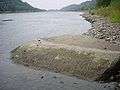 |
| Elbe | Dresden-Pillnitz, near the stairs of Pillnitz Castle's western sphinx | Years: 1778, 1893, 1904, 2003, 2018. | .JPG) |
| Elbe | Dresden-Laubegast | Years: 1893, 1899, 2003, 2015. | .JPG) |
| Elbe | Dresden-Tolkewitz, near Tolkewitzer Street 73 | Year: 2016. | .JPG) |
| Elbe | Dresden-Blasewitz | 2 by 2 meter stone near kilometer 48.7 with years: 1930, 1943, 1947, 1950, 1963 etc. | |
| Elbe | Radebeul-Kötzschenbroda, near the steam ship port | Year 1811[8] | .JPG) |
| Elbe | Meißen | Was recorded by Johann Friedrich Usinus to have been spotted in 1746 bearing the carving of the year 1654[9] | |
| Elbe | Torgau, on the right side near the destroyed bridge | Can be seen at a water level of 50 cm or lower | 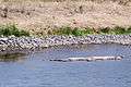 |
| Elbe | Schönebeck (Elbe), near kilometer 311 on the right riverbank | Measuring 1,5 by 1,5 by 2 meters and weighing 10 tons | 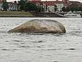 |
| Elbe | Schönebeck (Elbe), museum of the city (formerly in the port) | 47 cm in size, year: 1904 | 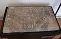 |
| Elbe | Westerhüsen, part of Magdeburg | see Hungerstones near Westerhülsen | 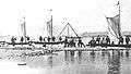 |
| Elbe | Magdeburg, Domfelsen | Red sandstone formation near Domfelsen,also called Hungerfelsen (lit. "hunger cliff"); carved 2018 in August | 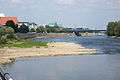 |
| Elbe | Bleckede, near the ferry port | Kilometer 550. Carved with the sentence: Geht dieser Stein unter, wird das Leben wieder bunter (lit. When this stone sinks, life will become more colorful again) [10] | |
| Moselle | Traben-Trarbach-Litzig, left riverside | ||
| Mündesee | Angermünde, north of the village | ||
| Rhine | Worms-Rheindürkheim, near kilometer 449.4 on the left riverbank | Several stones, years ranging from 1857 to 2009 | 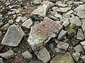 |
| Weser | Near Hajen, on the left riverbank | Red sandstone that was smoothed by the river | 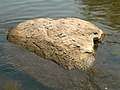 |
| Weser | Würgassen | 3 m³ hunger stone with the years 1800, 1840, 1842, 1847, 1850, 1857, 1858, 1859, 1865, 1874, 1876, 1881, 1911, 1922, 1934 and 1959[11] |
Common years
| Year | Number of hunger stones marked |
|---|---|
| 1115 | 1 |
| 1417 | 1 |
| 1461 | 1 |
| 1616 | 1 |
| 1654 | 1 |
| 1666 | 1 |
| 1681 | 1 |
| 1707 | 2 |
| 1746 | 1 |
| 1778 | 1 |
| 1790 | 1 |
| 1800 | 2 |
| 1811 | 2 |
| 1830 | 1 |
| 1840 | 1 |
| 1842 | 3 |
| 1847 | 1 |
| 1850 | 1 |
| 1857 | 2 |
| 1858 | 1 |
| 1859 | 1 |
| 1865 | 1 |
| 1868 | 2 |
| 1874 | 1 |
| 1876 | 1 |
| 1881 | 1 |
| 1892 | 3 |
| 1893 | 3 |
| 1899 | 1 |
| 1903 | 1 |
| 1904 | 5 |
| 1911 | 2 |
| 1921 | 2 |
| 1922 | 1 |
| 1928 | 2 |
| 1930 | 1 |
| 1934 | 1 |
| 1943 | 1 |
| 1947 | 2 |
| 1950 | 1 |
| 1952 | 1 |
| 1959 | 2 |
| 1963 | 3 |
| 1971 | 1 |
| 2003 | 3 |
| 2009 | 1 |
| 2015 | 7 |
| 2016 | 1 |
| 2018 | 6 |
See also
References
- Damonoske, Camila (2018-08-24). "Drought In Central Europe Reveals Cautionary 'Hunger Stones' In Czech River". NPR.org. Retrieved 2018-08-28.
- Lederer, David. German History in Global and Transnational Perspective, Springer. Aug. 8, 2017. pp. 24
- Associated Press. "'Hunger Stone' appears," The New York Times. Aug. 1, 1918. pp. 1
- Dockrill, Peter. "Sinister 'Hunger Stones' With Dire Warnings Have Been Surfacing in Europe". Science Alert. Archived from the original on 27 August 2018. Retrieved 28 August 2018.
- "Labe je 24 centimetrů pod hladinou sucha, odhalilo všechny hladové kameny". iDNES.cz. 2018-07-25. Retrieved 2018-08-28.
- "Vysychající koryto Labe odkrývá na Děčínsku hladové kameny". iDNES.cz. 2016-09-12. Retrieved 2018-08-28.
- Riegel, Nancy (2018-08-02). "Die stillen Zeugen der Elbe". Sächsische Zeitung. Archived from the original on 2018-08-02. Retrieved 2018-08-02.
- "Zeuge schlechter Zeiten". SZ-Online (in German). 2018-08-11. Archived from the original on 2018-08-15. Retrieved 2018-08-28.
- Johann Friedrich Ursinus: Collektania zur Geschichte der Stadt und des Landes Meißen, 1790.
- "Bleckede: Schwindende Elbe legt Hungerstein frei | Deutschland News". aktnach.org. Archived from the original on 2018-08-29. Retrieved 2018-08-28.
- Karl Löbe: Das Weserbuch. Roman eines Flusses. Hameln: Verlag C. W. Niemeyer. 1968
| Look up hunger stone in Wiktionary, the free dictionary. |