Huayi tu
The Hua Yi Tu (華夷圖, Map of China and the Barbarian Countries) is a map engraved as a stone stele in 7th year of Fuchang era (1136 CE). It is the earliest surviving map of China that relates China with other foreign states.[2] The stele is now in the Stele Forest or Beilin Museum (碑林; pinyin: Bēilín) in Xi'an, China.[3]

Origin
The stele was commissioned under the Great Qi dynasty, a puppet state of the Jurchen Jin which ruled over northern China at that time. The stone stele stands 1136.79 tall and 79 cm wide, with the map measuring 79 cm high and 78 cm wide.[4] An unknown cartographer engraved the Huayi map.
Features
The map depicts mountains, rivers, lakes, as well as more than 400 administrative place names of China. It covers an area bounded in the north by the Great Wall of China, northeast by Heilongjiang region, extending south to the island of Hainan.[1][5] At the edges of the map are a few other states such as Korea (Goryeo) on the northeast and India (Tianzu) on the southwest.[6]
The map of China is surrounded by blocks of texts, which references back to the Tang dynasty map of Jia Dan (scholar and cartographer) called Hainei Huayi Tu (Map of China and the Barbarian Countries within the Seas) presented to Emperor Dezong of Tang in 801.[7] The later Huayi Tu map covers China during the Jin and Southern Song Dynasty. The texts arranged around the edges of the map provides information from historical and other sources briefly explaining markers such as the Great Wall, the size of the empire, brief descriptions of Korea, Japan and other foreign states as well as lists of the states to the south and west of China.[8]
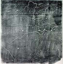
on the reverse side of Huayi tu is the gridded Yu Ji Tu (Map of the Tracks of Yu the Great) carved in 1142. This map is the earliest surviving example of lattice cartographic grid found in Chinese map.[6][9]
The stele containing the carved map is thought to be stored at the Stele Forest in Xi'an, but is not displayed due to the political sensitivity of not depicting the island of Taiwan on it,[10] which can be interpreted as Taiwan not belonging to China at the time of the map's production.
References
- "Hua yi tu". Library of Congress. Retrieved 13 August 2017.
- Morris Rossabi, ed. (2013). Eurasian Influences on Yuan China. ISEAS Publishing. p. 131. ISBN 978-9814459723.
- "Huayi Tu (Map of China and Barbarian Countries)". Museum of the Institute of History and Philology.
- Knowledge and Text Production in an Age of Print: China, 900-1400. p. 249. ISBN 9789004193864.
- De Weerdt, Hilde (2009). "Maps and Memory: Readings of Cartography in Twelfth- and Thirteenth-Century Song China". The International Journal for the History of Cartography. 61 (2): 145–167. doi:10.1080/03085690902923572.
- Smith, Richard J. (2013). Mapping China and Managing the World: Culture, Cartography and Cosmology in Late Imperial Times. London: Routledge. pp. 56–58. ISBN 978-0-415-68509-2.
- Bagrow, Leo (1963). History of Cartography. London: Transaction Publishers. p. 199.
- Siebold, Jim. "The Xian-or-Southern Sung Maps: the Hua I T'u". My Old Maps. Retrieved 13 August 2017.
- Siebold, Jim. "Yü Chi T'u" (PDF). My Old Maps.
- Lindesay, William (2015). The Great Wall in 50 objects. Melbourne, Vic: Viking, an imprint of Penguin Books. p. 93. ISBN 9780734310484.
External links
- Chinese cartography website by Qiming Zhou, Hong Kong Baptist University- accessed 2008-03-16
- My Old Maps website by Jim Siebold, 2015.