Horninglow
Horninglow is a suburb of Burton upon Trent in East Staffordshire. Horninglow lies to the north west of Burton, and is linked to the town centre by the A511.[1]
| Horninglow | |
|---|---|
 Horninglow Location within Staffordshire | |
| OS grid reference | SK244250 |
| District | |
| Shire county | |
| Region | |
| Country | England |
| Sovereign state | United Kingdom |
| Post town | BURTON-ON-TRENT |
| Postcode district | DE13 |
| Dialling code | 01283 |
| Police | Staffordshire |
| Fire | Staffordshire |
| Ambulance | West Midlands |
| UK Parliament | |
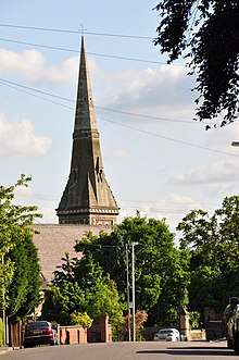
The parish church of Horninglow is St John the Divine, part of the Diocese of Lichfield.
Area
Horninglow is one of the older parishes, shown on maps as early as 1770. Over time its development has increased the size of the area to its current layout.
In recent years, Horninglow has become a popular place to live with a wide variety of housing. Horninglow's one grade II listed building, the Chestnuts farmhouse on Horninglow Road North, is being developed with barns being converted to residential accommodation as of 2008.
Education
Horninglow has a number of schools at both the primary and secondary school level.[2] Primary schools include Horninglow Primary: A De Ferrers trust academy, Outwoods Primary School (formerly Castle Park Infants School and William Hutson Junior School), Lansdowne Infant School, Eton Park Junior School, Belvedere Junior School and St Modwen's Roman Catholic Primary School.
The secondary school in Horninglow is the De Ferrers Academy, which is split between two sites, the Dove Campus in Harehedge Lane and the Trent Campus in St Mary's Drive. De Ferrers was recognised as good with outstanding features by Ofsted in April 2012.[3]
Notable people
- Alan Mellor, English cricketer