Honeysuckle Creek Tracking Station
Honeysuckle Creek Tracking Station (Honeysuckle Creek) was a NASA Earth station in Australia near Canberra,[1] and was instrumental to the Apollo Program. The station was opened in 1967 and closed in 1981.[2]
| Location(s) | Tennent, Australian Capital Territory, AUS |
|---|---|
| Coordinates | 35°35′01″S 148°58′37″E |
| Telescope style | ground station |
 Location of Honeysuckle Creek Tracking Station | |
History
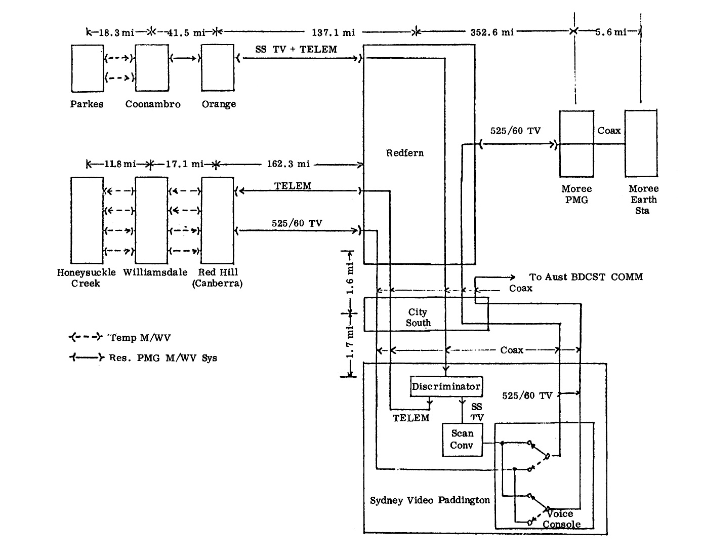
Honeysuckle Creek – with a 26m dish (now relocated and decommissioned) – is renowned as the station which received and relayed to the world the first televised footage of astronaut Neil Armstrong setting foot on the Moon on 20 July 1969. Apart from television pictures, Honeysuckle Creek and Canberra Deep Space Communications Complex (Tidbinbilla) had communication and telemetry contact with the Eagle lunar and Columbia command modules. Much of this was dramatized as involving Parkes Observatory (Parkes) in the 2000 Australian film The Dish. In fact, Parkes received only the landing footage. Six hours later, the first steps on the Moon were transmitted from Honeysuckle Creek. Although the Parkes antenna was more powerful, the angle of its dish – at a lowermost pitch of 30-degrees and buffeted by wind gusts up to 100 km/h – was not in line to receive signals during the first seven minutes of the Moon Walk.[3] Honeysuckle Creek signals were sent direct to OTC Sydney via Williamdale and Red Hill (Canberra).[4] Working for NASA, Charlie Goodman selected the audiovisual feeds from Honeysuckle Creek and Parkes for worldwide broadcasts.
The Honeysuckle Creek and Tidbinbilla antennas were built and run by NASA, but staffed by Australians. It was the policy of the Australian Government that the director had to be a citizen or permanent resident of Australia. When Apollo missions ended in 1972, Honeysuckle Creek was redirected to the new Skylab program. As well, it was used for experiments with Apollo scientific stations placed on the Moon by astronauts.
At the end of the Skylab program in 1974, Honeysuckle Creek was connected to the Deep Space Network with the designation Deep Space Station 44. Honeysuckle Creek closed in December 1981. The 26m antenna was relocated nearby to the Canberra Deep Space Communications Complex at Tidbinbilla, and redesignated Deep Space Station 46. The Antenna was decommissioned in late 2009. In May 2010, the American Institute of Aeronautics and Astronautics declared the antenna a Historical Aerospace Site. The antenna remains in perpetuity as a historical site at Tidbinbilla.[5]
Today, at Honeysuckle Creek, the concrete foundation is the only remnant of the tracking station. An outdoor display was added in 2001. Honeysuckle Creek is considered the geographical centre of the Australian Capital Territory.[6]
Climate
The climate at Honeysuckle Creek—as to be expected of its much greater altitude—is significantly cooler than that of Canberra. Notwithstanding, it is rather warm for its altitude and latitude due to the fact that it still lies on the leeward side of the ranges; in this case, it lies in the lee of the Brindabella Range—the northernmost branch of the Snowy Mountains.
Annually, it receives 14.4 snowy days on average.[7]
| Climate data for Honeysuckle Creek, ACT (Honeysuckle Creek); 1,116 m AMSL; 35° 34′ 59.88″ S | |||||||||||||
|---|---|---|---|---|---|---|---|---|---|---|---|---|---|
| Month | Jan | Feb | Mar | Apr | May | Jun | Jul | Aug | Sep | Oct | Nov | Dec | Year |
| Record high °C (°F) | 36.1 (97.0) |
34.7 (94.5) |
30.0 (86.0) |
26.1 (79.0) |
20.0 (68.0) |
17.2 (63.0) |
16.2 (61.2) |
19.2 (66.6) |
23.2 (73.8) |
26.1 (79.0) |
32.2 (90.0) |
35.0 (95.0) |
36.1 (97.0) |
| Average high °C (°F) | 23.3 (73.9) |
23.0 (73.4) |
19.9 (67.8) |
15.9 (60.6) |
11.4 (52.5) |
8.5 (47.3) |
7.9 (46.2) |
9.1 (48.4) |
12.1 (53.8) |
15.8 (60.4) |
18.3 (64.9) |
22.1 (71.8) |
15.6 (60.1) |
| Average low °C (°F) | 10.7 (51.3) |
11.0 (51.8) |
8.7 (47.7) |
5.2 (41.4) |
2.5 (36.5) |
−0.1 (31.8) |
−1.1 (30.0) |
−0.2 (31.6) |
1.5 (34.7) |
4.5 (40.1) |
6.4 (43.5) |
8.6 (47.5) |
4.8 (40.7) |
| Record low °C (°F) | 1.4 (34.5) |
1.1 (34.0) |
−1.0 (30.2) |
−4.0 (24.8) |
−6.1 (21.0) |
−7.0 (19.4) |
−7.8 (18.0) |
−11.1 (12.0) |
−6.1 (21.0) |
−6.5 (20.3) |
−3.3 (26.1) |
−0.6 (30.9) |
−11.1 (12.0) |
| Average precipitation mm (inches) | 93.0 (3.66) |
104.7 (4.12) |
78.2 (3.08) |
88.4 (3.48) |
74.6 (2.94) |
58.9 (2.32) |
57.9 (2.28) |
92.9 (3.66) |
86.9 (3.42) |
112.0 (4.41) |
85.2 (3.35) |
67.3 (2.65) |
1000 (39.37) |
| Average precipitation days | 11.4 | 10.9 | 11.1 | 9.4 | 11.4 | 11.3 | 10.9 | 13.3 | 12.7 | 13.5 | 12.0 | 8.4 | 136.3 |
| Source: Bureau of Meteorology; Honeysuckle Creek, ACT | |||||||||||||
Gallery
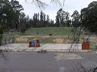 The former Honeysuckle Creek tracking station, October 2004
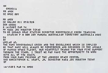 Copy of telex sent to Director of Honeysuckle Creek tracking station
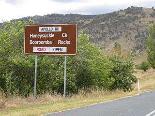 Apollo Road – The road to Honeysuckle Creek
See also
- Apollo 11 missing tapes
- Carnarvon Tracking Station
- Orroral Valley Tracking Station
- OTC Satellite Earth Station Carnarvon
- Canberra Deep Space Communication Complex
- History of the Deep Space Network
- Andrew Tink's 2018 book: Honeysuckle Creek: the story of Tom Reid, a little dish and Neil Armstrong’s first step[3] Tom Reid was the Director of Honeysuckle between 1967 and 1970 and in particular on 20–21 July 1969 during Neil Armstrong's moon walk.
References
- "Google Maps". Google Maps.
- Mackellar, Colin (10 April 2010). "A Tribute to Honeysuckle Creek Tracking Station". Retrieved 23 April 2010.
- Tink, A. A. (Andrew A.) (2018), Honeysuckle Creek : the story of Tom Reid, a little dish and Neil Armstrong's first step, NewSouth Publishing, ISBN 978-1-74223-608-7
- "Diagram". honeysucklecreek.net. Retrieved 22 October 2019.
- "AustraliaHistoricalSite" (PDF). American Institute of Aeronautics and Astronautics. Archived from the original (PDF) on 11 July 2010. Retrieved 18 July 2010.
- Australia, c\=AU\;o\=Australia Government\;ou\=Geoscience (15 May 2014). "Centre of Australia States and Territories". www.ga.gov.au.
- "Untitled Document".