Historical atlas
A historical atlas is an atlas that includes historical maps and charts depicting the evolving geopolitical landscape. They are helpful in understanding historical context, the scope and scale of historical events and historical subjects (such as the expansion of the Roman Empire), and macro-history. Some historical atlases try to present the entire history of the world, such as the Historical Atlas of the World, while others are more specialised, for only one time period or location, such as the Historical Atlas of the American West or The Historical Atlas of China. They may also include historical photographs and explanatory text or essays.
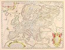
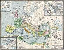
The first known historical atlas was the Parergon by Abraham Ortelius in 1579, which was a supplement to the Theatrum Orbis Terrarum. William R. Shepherd produced a well-known historical atlas in 1911.[1]
See also
- Category:Historic maps
- Timeline
References
- "Historical Atlas by William R. Shepherd - Perry-Castañeda Map Collection - UT Library Online". legacy.lib.utexas.edu.
External links
| Wikimedia Commons has media related to Historical atlas. |
| Wikimedia Commons has media related to Maps showing history. |
- Clockwork Mapping: Centennia Historical Atlas
- Euratlas History Maps History maps form year 1. AD
- Maps and History. Constructing Images of the Past
- F. W. Putzgers Historischer Schul-Atlas, Ausgabe von 1905
- F. W. Putzgers Historischer Schul-Atlas, Ausgabe von 1914
- A multimedia atlas with historical animated maps
- Richard Andree: Professor G. Droysens Allgemeiner Historischer Handatlas, 1886
- R. Lane Poole: Historical Atlas of Modern Europe, 1900
- Atlas-Historique.net
- Server für digitale historische Karten am Institut für Europäische Geschichte in Mainz
- Historischer Atlas von Bayern
- Geschichtlicher Atlas von Hessen
- Historischer Atlas von Sachsen (1815)
- Maps from the 'Imperial Gazetteer of India' (ein Angebot der 'Digital South Asia Library')
- Joseph E. Schwartzberg, A Historical Atlas of South Asia, second impression.
- Geschichtskarten zum Islam
- Digitalisierungsprojekt Wilhelmshöher Kriegskarten
- Omniatlas - Interactive Atlas of World History
- Running Reality – See any day in history from 3000BC to today, including changing national borders, battles, etc.
| Authority control |
|
|---|