Highway 40 (Saudi Arabia)
Highway 40 is a major 1,334 km (829 mi) long transnational interprovincial highway that runs from Highway 5 near Jeddah to Highway 615 near Dammam and travels through the center of Saudi Arabia. It is an east–west highway and the only coast-to-coast highway in the kingdom. The Highway connects Jeddah on the western Red Sea coast to Dammam on the eastern Persian Gulf coast, running through or near the cities of Makkah, Ta'if, Riyadh, Abqaiq and Khobar along its Highway. The highway passes through the provinces of Makkah (al-Makkah al-Mukarramah), Riyadh (ar-Riyadh) and the Eastern Province (ash-Sharqiyah). Several connector roads and highways connect the highway to other major roads and highways along its Highway. Highway 40 been cited as the most developed highway in the kingdom overall.
| |
|---|---|
| Route information | |
| Length | 1,334 km (829 mi) |
| Time period | 1986-present |
| Major junctions | |
| West end | |
| East end | |
| Location | |
| Major cities | Jeddah, Makkah, Riyadh, Dammam |
| Highway system | |
| Transport in Saudi Arabia | |


Mashreq network designation
Highway 40 carries Mashreq Highway 80M for the entirety of its length except for the final 6 km (4 mi) near Dammam where 80M turns southward to follow Highway 95 toward the King Fahd Causeway and Bahrain. It is marked with Highway markers for both highways along its Highway. Mashreq 80M is one of the most important Highways in the Mashreq road network and the only one through Bahrain.
Highway description
| Section | km | mi |
|---|---|---|
| Makkah - Jeddah Expressway
طريق مكة - جدة السريع |
43 | 27 |
| Makkah
Qasr Al Diyafah - Al Hujoon St. - King Faisal Rd. قصر الضيافة - شارع الحجون - طريق الملك فيصل |
39 | 24 |
| Riyadh - Makkah Expressway
طريق الرياض - مكة السريع |
834 | 518 |
| Riyadh
Western Ring Rd. - Northern Ring Rd. الطريق الدائري الغربي - الطريق الدائري الشمالي |
43 | 27 |
| Dammam - Riyadh Expressway
طريق الدمام - الرياض السريع |
375 | 233 |
| Total | 1,334 | 829 |
Makkah Province (al-Makkah al-Mukarramah)
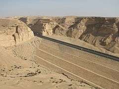
Highway 40 begins at the final southern intersection of Highway 5 (also Mashreq Highway 55M) in the al-Waziriyah district of Jeddah. It exits the city travelling east for 43 km (27 mi) and reaching Makkah at the Western Haram boundary. Highway 40 then continues through Makkah for the next 39 km (24 mi), intersecting the 4th Ring Rd. and 3rd Ring Rd. of Makkah as it approaches the Islamic holy city. After the intersection with the 3rd Ring Rd., it turns northward, being carried by Qasr Al Diyafah before turning east, running concurrently with Highway 290 as Al-Hujun St. It then runs south of Jabal Al-Nour, before reaching the Eastern Haram boundary and exiting Makkah. Highway 40 then continues eastward, passing through the Hijaz mountain range and the towns of Al Ju'ranah, Al Sharai', Zemah, and Al Sayl, before turning back south-east north of Ta'if, at the intersections with Highway 287 (Al Sail Rd.) and Highway 267, before turning back north-east towards Riyadh. Highway 40 then continues north-east, passing through 'Ateef and New Muwayh before it intersects Highway 50 at Dhalim.
Riyadh Province (ar-Riyadh)
Entering Riyadh Province and continues for 462 km, passing through several small towns before reaching Riyadh, the capital of Saudi Arabia, at the intersection with Highway 500 (Western Ring Rd.). Highway 40 then bends northward before turning back east at Doha Square/Exit 1 (ميدان الدوحة / مخرج 1). It then intersects Highway 537 (Al Takhassusi St.), Highway 65 (Highway 35M) at Rabat Square/Exit 4, Highway 539 (Airport Rd.) and Highway 550 (Al Janadriyah Rd.) before exiting Riyadh. Highway 40 then intersects Highway 522 (Khurais Rd.), before exiting Riyadh Province.
Eastern Province (ash-Sharqiyyah)
As it enters the Eastern Province, the highway intersects Highway 522 once again, 10 km from the border. 161 km further, it intersects Highway 30 (Highway 60M) near Judah. It then intersects Highway 607 near Salasil. After it reaches Greater Dammam, it intersects Highway 95 (also Mashreq Highway 5M), before terminating at the intersection with Highway 613.
See also
Notes
- Since Saudi Arabia does not have any official report, diagram, or any other document with reference to its highways, all the length estimates have been taken using the "Measure distance" tool on Google Maps. This method of measurement can and does come with errors, so the validity of the length estimates in this article is questionable.