High Stones
High Stones, at 550 metres (1,804 ft), is the highest point within the boundaries of both Sheffield and South Yorkshire, England. It lies on the Howden Moors towards the northern boundary of the Peak District National Park, between Langsett Reservoir to the north east and Howden Reservoir to the south west. The area is managed by the National Trust, as part of the Nether Hey area of their High Peak Estate.
| High Stones | |
|---|---|
 High Stones, Sheffield | |
| Highest point | |
| Elevation | 548 m (1,798 ft) |
| Coordinates | 53°26′43″N 1°43′06″W |
| Geography | |
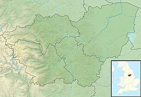 High Stones High Stones in South Yorkshire | |
| Location | South Yorkshire, |
| Parent range | Peak District |
| OS grid | SK188943 |
High Stones is about 1 mile (1.6 km) south of Margery Hill which, at 546m, is the highest marked point within Sheffield. High Stones is only shown on 1:25,000 scale maps and larger.
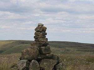
The cairn at High Stones is at the marked 548 metres (1,798 ft) point; being something over two feet tall means that the top of the cairn is just over 1800 ft above sea level. The most recent 1:25,000 Ordnance Survey Map[1] shows a small 550m contour just west of the High Stones marked point, meaning that small patch of moorland is the highest point in Sheffield at just slightly over 550 metres (1,804 ft).
References
- "Ordnance Survey Map of High Stones". Archived from the original on 26 October 2012. Retrieved 6 February 2011.
Peaks of the Peak District of England | ||
|---|---|---|
| Marilyns |  | |
| Other peaks |
| |
List of peaks of the Peak District | ||