Henricus Martellus Germanus
Henricus Martellus Germanus is the latinized name of Heinrich Hammer (Italian: Enrico Martello), a geographer and cartographer from Nuremberg who lived and worked in Florence from 1480 to 1496.
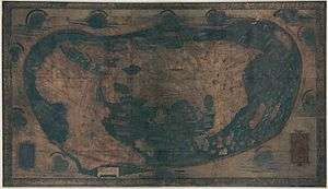
Between around 1489 and 1491, he produced at least one world map which is remarkably similar to the terrestrial globe produced by Martin Behaim around 1492, the Erdapfel. Both show novel adaptions of the existing Ptolemaic model, opening a passage south of Africa and creating an enormous new peninsula east of the Golden Chersonese (Malaysia). Both possibly derive from maps created around 1485 in Lisbon by Bartolomeo Columbus.
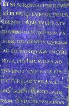
The only extant manuscript world map, measuring 201 by 122 centimetres (79 in × 48 in) in size, was rediscovered in the 1960s[1] and donated to Yale's Beinecke Rare Book and Manuscript Library.[2] An inscription in the lower left corner states: "Although Strabo and Ptolemy and the majority of the ancients were most assiduous in describing the world we, however, bring together in this picture and carefully show in their true places the new knowledge that escaped their diligence and remained unknown to them".[3]
A 2014 multispectral imaging project led by Chet van Duzer revealed many previously-illegible details of the map, including a depiction of a porcupine in northern Asia, references to mythological peoples such as the Hippopodes and the Panotti, and a surprising amount of information about the interior of Africa- knowledge that likely originated with the Ethiopian delegation to the 1441 Council of Florence [4]
Martellus’ map served as an inspiration for the Waldseemüller map of 1507. The overall layout was similar, and Martin Waldseemüller used the same projection as Martellus, the pseudo-cordiform projection. Both cartographers added decorative wind-heads in the borders of their maps, and both also took advantage of the extra space in the lower corners of the maps created by the swooping lines of the projection to add text blocks in those corners. The shape of northern Africa is the same on both maps, that is, it is Ptolemaic with a sharp northwestern corner. The shape of eastern Asia is similar on the two maps, with a huge peninsula jutting southwestward into the Indian Ocean, and Japan is in precisely the same position on the two maps, at the eastern edge.[5]
Martellus also produced an Insularium Illustratum ("Illustrated Book of Islands") of which four manuscripts are extant, plus one draft in Biblioteca Laurentiana. It contains an illustrated description of islands of the Aegean Sea, mostly copied from a previous work by Cristoforo Buondelmonti, plus maps from other islands, several regional maps and a world map.[6]
He has been identified with an Arrigho di Federigho who authored the first translation into German of Bocaccio's Decamerone. According to this theory, the surname Martellus would come from the Martelli family, to which Henricus / Arrigho was linked.[7]
References
- Urbanus, Jason (Jan–Feb 2016). "Reading the Invisible Ink" (PDF). Archaeology. 69 (1): 9–10. ISSN 0003-8113. Retrieved 31 August 2017 – via EBSCO's Master File Complete (subscription required)
- Hammer, Heinrich. "Map of the world of Christopher Columbus". Beinecke Rare Book & Manuscript Library. Yale University. Retrieved 31 August 2017.; Chet Van Duzer, Henricus Martellus’s World Map at Yale (c. 1491): Multispectral Imaging, Sources, and Influence, Berlin, Springer International Publishing, 2018.
- ETSI STRABO AC PTOLEMEUS ET PLERIQUE VETERUM DESCRIBENDI ORBIS FUERE STUDIOSISSIMI NOVORUM TAMEN DILIGENTIA QUEDAM AB EIS TANQUAM INCOGNITA PRETERMISSA ADINVENIT QUE NOS HOC PICTURE AD VERAM LOCORUM SCIENTIAM EXPRIMENDAM STUDIOSE IUNXIMUS
- Miller, Greg. "A 500-year-old map used by Columbus reveals its secrets". National Geographic. Retrieved 26 August 2019.
- Chet Van Duzer, “Waldseemüller's World Maps of 1507 and 1516: Sources and Development”, The Portolan, No.1, Winter 2012, p.12.
- Bouloux, Nathalie (2012). "L'Insularium Illustratum d'Henricus Martellus". The Historical Review / La Revue Historique. IX: 77–94. Retrieved 30 September 2016.
- Rezension von L. Böninger: Die deutsche Einwanderung nach Florenz (2006)
External links
| Wikimedia Commons has media related to Henricus Martellus Germanus. |
- Arthur Davies: Behaim, Martellus and Columbus, The Geographical Journal, Vol. 143, No. 3 (Nov., 1977), pp. 451-459
- Alexander O. Vietor: A Pre-Columbian Map of the World, Circa 1489, Imago Mundi, Vol. 17, 1963 (1963), pp. 95-96
- An essay on the world maps created by Henricus Martellus Germanus
- Recent findings via multispectral imaging: presentation by Chet van Duzer, Hidden secrets of Yale’s 1491 world map revealed via multispectral imaging press release by Yale University.
| Authority control |
|
|---|