Hatton, Derbyshire
Hatton is a village and civil parish in South Derbyshire, England. It is located 6 km north of Burton upon Trent, 20 km west of Derby and 40 km east of Stoke-on-Trent. The population of the civil parish as of the 2011 census was 2,785.[1]
| Hatton | |
|---|---|
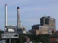 The Coffee Factory | |
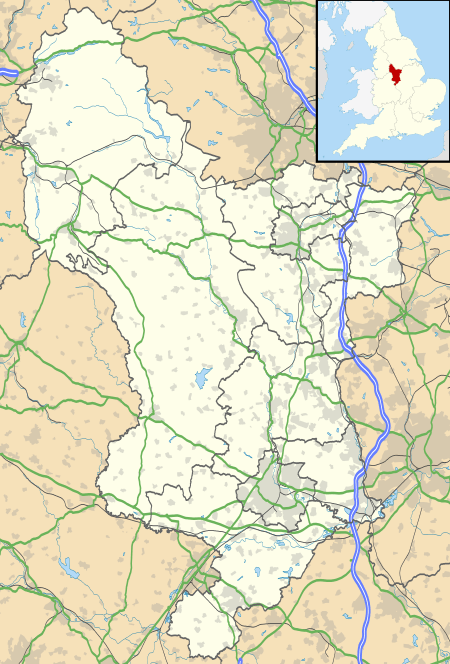 Hatton Location within Derbyshire | |
| Population | 2,785 (2011) |
| OS grid reference | SK215300 |
| District | |
| Shire county | |
| Region | |
| Country | England |
| Sovereign state | United Kingdom |
| Post town | DERBY |
| Postcode district | DE65 |
| Dialling code | 01283 |
| Police | Derbyshire |
| Fire | Derbyshire |
| Ambulance | East Midlands |
| UK Parliament | |
Geography
Hatton is about half a mile north of Tutbury, Staffordshire with the River Dove running between the two villages and creating the county boundary; the river is crossed by a listed bridge. It has a population of 2,690 and is mainly residential.
The village is close to the A50 road which links the M1 and M6. The A50 used to pass across the northern edge of the village, but was bypassed in May 1995 by the 6-mile £19million Hatton, Hilton and Foston Bypass. The former route is now the A511, which passes through the village from Tutbury. Tutbury and Hatton railway station is on the Nottingham to Crewe line. Services are provided by East Midlands Railway. The station was originally closed in the Beeching cuts in the 1960s, but was re-opened in the 1980s (like other previously-closed rural stations) due to public demand. Local bus services are provided by Midland Classic who link Hatton with the market towns of Burton-upon-Trent and Uttoxeter, and Trent Barton who link with Derby and Burton-upon-Trent.
The village is within the district of South Derbyshire District Council and County of Derbyshire County Council. The local MP is Heather Wheeler, who was elected in 2010.
Environment
The land adjacent to the River Dove is home to 'Thistley Meadow' community nature reserve. From this southern part of the village there are views across the river to Tutbury Castle and the long horizon beyond adds to the open panoramic views from the bridge. Towards the northern part of the village there is a good network of footpaths and bridle ways which can be used to navigate round the village or used as a link to the neighbouring villages of Hilton and Marston-on-Dove; or even further beyond into the less populated villages of South Derbyshire which link Hatton with the open farmland that reaches up towards Ashbourne and the Peak District National Park. Heathland and pasture are the dominant environmental features contrasting with the residential and commercial aspects of the village.
Economy
Local employers include Nestlé who have a historical presence in the village due to the surrounding farmland, which supported a strong dairy farming industry, and proximity to rail transport. Nestlé's factory is labelled by the company as their Tutbury factory. Until the late 1970s the factory had its own private siding, which gave access to milk trains. The factory since has developed into a major coffee producer, the sole United Kingdom facility producing the Dolce Gusto range, and also Nescafé.[2] During 2012 the company started to expand production and has made a multimillion-pound investment over the last few years to establish the site further.
The village has a famous café, The Salt Box on the A511, which has won awards as the best transport café in the UK. There is no similar truck stop on the parallel A50, hence its popularity. Opposite the cafe is the Sunar Gow, Indian restaurant and nearby is the Railway Tavern pub. There is a Co-op supermarket in the village, next to the railway station, as well as a Post Office, two newsagents and several other village shops and food outlets.
History
Hatton was mentioned in the Domesday book as belonging to Henry de Ferrers[3] and being worth twenty shillings.[4] The parish church is All Saints.
It is estimated that in 1880 the village had around 500 residents.[5] The population has since quintupled.
Notable historical residents
- John Berry (1920-2010), designer of the Esso tiger in the 1950s, and many children's reference books for Ladybird Books.[6]
- Roger Davies (born 1950), ex-Derby County footballer.
- Jody Bunting (born 1978), TV fitness expert from Channel 4's former morning show The Big Breakfast.[7]
References
- "Civil Parish population 2011". Neighbourhood Statistics. Office for National Statistics. Retrieved 26 March 2016.
- "Archived copy". Archived from the original on 8 February 2008. Retrieved 11 March 2008.CS1 maint: archived copy as title (link)
- Henry was given a large number of manors in Derbyshire including Brailsford, Aston-on-Trent, Pilsbury and Bradley.
- Domesday Book: A Complete Translation. London: Penguin, 2003. ISBN 0-14-143994-7 p.745
- "GB Historical GIS. University of Portsmouth, Hatton Tn/CP through time. Population Statistics. Total Population, A Vision of Britain through Time". Retrieved 11 April 2015.
- John Berry, Obituary, The Guardian, retrieved 10 April 2015
External links
| Wikimedia Commons has media related to Hatton, Derbyshire. |