Hatsusaburō Yoshida
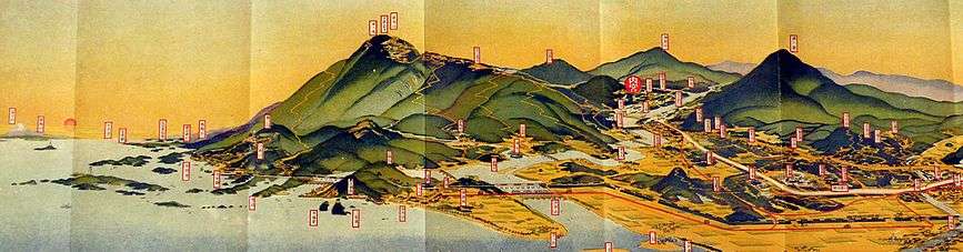
Hatsusaburō Yoshida (吉田 初三郎, Yoshida Hatsusaburō, March 4, 1884 – August 16, 1955) was a Japanese cartographer and artist, known by his bird's-eye view maps of cities and towns. Known as the "Hiroshige of the Taisho Era,"[1] Yoshida created over 3000 maps in his lifetime.[2]
Biography
Yoshida was born in Kyoto in 1884 as Hatsusaburo Izumi. His father died when he was a year old, so he adopted his mother's surname. At age 10, Yoshida became a textile designer apprentice, making yūzen for kimonos. When he turned 25, he studied foreign painting with Masaro Kagiki, but turned to commercial art at Kagiki's recommendation. In 1914, his first bird's-eye view "Keihan Train Guide" was praised by Emperor Showa (then Crown Prince), who was aboard the Keihan Train on a school trip. The popularity of Hatsushiro's birds-eye view maps increased due to the tourism boom in Japan from Taisho to Showa era. Yoshida established the Taishō meisho zue-sha (Taisho famous places' illustration company), which was later renamed Kankō-sha (Tourism company). Yoshida visited the places which he depicted on maps, talking to people and studying popular attractions.
In 1921, in commemoration of the 50th anniversary of the introduction of rail transport in Japan, the Ministry of Railways decided to publish "Railway Travel Information" guides with maps illustrated by Yoshida. He also made posters for the International Tourism Bureau's "Beautiful Japan" campaign in the 1930s.[3]
During that decade Yoshida was flooded with requests to create a bird's-eye maps from the whole country (including Manchuria and Taiwan). He hired disciples to help with his works, while moving his base to Inuyama City and Hachinohe City (Tanesashi Coast). He also received requests from many friends, like royalty such as Prince Takamatsu and soldiers such as Iwane Matsui. However, during World War II, Yoshida's map production slowed down; the military judged those maps would be inconvenient in that time, as they would potentially reveal military secrets, such as secret harbors, to the enemy.
After the war Yoshida's first major work was a bird's-eye view of the aftermath of the Hiroshima atomic bombing.[2]
Yoshida died in 1955. In 1999, a retrospective exhibition about his maps was held at the Sakai City Museum.[4]
References
| Wikimedia Commons has media related to Hatsusaburō Yoshida. |
- Wigen, Kären; Fumiko, Sugimoto; Karacas, Cary (2016-03-16). Cartographic Japan: A History in Maps. University of Chicago Press. ISBN 9780226073194.
- "Bird's Eye View Maps by Cartographer Hatsusaburo Yoshida". Spoon & Tamago. 2014-03-03. Retrieved 2017-01-10.
- "Japan's picture ID before World War II | The Japan Times". The Japan Times. Retrieved 2017-01-10.
- "Time Travel to Showa— The Panoramic World of Hatsusaburo Yoshida". Kansai Art Beat. Retrieved 2018-09-24.
| Authority control |
|
|---|