Hamilton Group
The Devonian Hamilton Group is a mapped bedrock unit in the United States. The unit is present in New York, Pennsylvania, Maryland, Ohio and West Virginia.[2][3] In Virginia, it is known as the laterally equivalent Millboro Shale.[4] The group is named for the village of Hamilton, New York.[5] Details of stratigraphic nomenclature for this unit as used by the U.S. Geological Survey are available on-line from the National Geologic Map Database.[6] These rocks are the oldest strata of the Devonian gas shale sequence.[7]
| Hamilton Group or Millboro Shale Stratigraphic range: Eifelian - Famennian[1] | |
|---|---|
| Type | Geological unit |
| Sub-units | Mahantango Formation Marcellus Formation |
| Underlies | Brallier Formation and Harrell Shale |
| Overlies | Marcellus Formation |
| Thickness | up to 2,500 feet (800 m) |
| Lithology | |
| Primary | Shale |
| Other | Limestone, Siltstone, Sandstone, Claystone |
| Location | |
| Region | Appalachian Basin of eastern North America |
| Extent | Maryland, New York, Pennsylvania, Virginia, and West Virginia |
| Type section | |
| Named for | Hamilton, New York |
| Named by | James Hall |
Description
Mostly shale, some sandstone.
Geographic Extent
The distribution of the unit can be observed on this map of Hudson-Mohawk bedrock scans.
Stratigraphic Setting
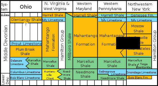
The Hamilton Group consists of the Mahantango Formation, a gray, dark gray, brown, and olive laminated shale; siltstone; and very fine-grained sandstone or claystone containing marine fossils. It overlies the Marcellus Shale, a fissile gray-black to black, thinly laminated, pyritic, carbonaceous thin shale with sparse marine fauna and siderite concretions. The total thickness of the Hamilton Group in Pennsylvania runs about 970 feet. In New York State, it thickens from 250 feet near Lake Erie to over 2,500 feet in Ulster and Greene counties. Depths ranging from outcrops to 8,000 feet below the surface of Sullivan County, in the southeastern part of the state.[7]
In the interior lowlands of New York, the Hamilton Group contains the Marcellus, Skaneateles, Ludlowville, and Moscow Formations, in ascending order, with the Tully Limestone above.[9] These units are divided by the Stafford, Centerfield, and Tichenor limestones.[10] In Ontario, Canada, the Hamilton Group formations are, in ascending order, Bell, Rockport Quarry, Arkona, Hungry Hollow, Widder, and Ipperwash; the Kettle Point Formation of the late Devonian lies unconformably above.[11]
The Mahantango Formation includes these members in descending order: Tully argillaceous limestone, Sherman Ridge, Montebello sandstone, Fisher Ridge, Dalmatia, and Turkey Ridge. In south-central Pennsylvania, it includes Clearville, Frame, Chaneysville, and Gander Run Members. Its thickness in Maryland ranges from 600 feet in the west, increasing to 1,200 feet in the east,[12] and approximately 1000 feet thick in central Pennsylvania.[13]
The Marcellus Formation contains a local limestone Purcell Member and Tioga bentonite at the base in eastern Pennsylvania. Its thickness in Maryland ranges from 250 feet in east, increasing to 500 feet in the west,[12] but is only about 70 feet thick in central Pennsylvania.[13]
The Hamilton Group, Tioga Metabentonite Bed, and Needmore Shale were formerly called the Romney Formation.[12]
- The Geneseo Shale is a dark grey to black shale that overlies the Tully Limestone; it includes the Filmore beds.[14]
- The Tully Limestone is a shallow-water carbonaceous unit.
- The Moscow Formation (Middle Devonian / Givetian) comprises grey to black shales interbedded with limestones and calcareous mudstones and usually bioturbated.[15]
Fossils
The uppermost clay regions of the Mahantango Formation are rich in fossils.[13]
Age
Relative age dating of the Hamilton places it in the middle and lower Devonian period. In Maryland, it rests conformably atop the Tioga Metabentonite Bed of thinly laminated shale with a thickness less than one foot over the Needmore Shale, and conformably below the Brallier Formation (formerly Woodmont Shale) dark laminated shale in the east, Harrell Shale dark laminated shale in the west, and Tully Limestone in the subsurface of Garrett County.[12] In Pennsylvania it lies atop the Onondaga Formation limestone and shale forming a sharp conformable contact with the Selinsgrove Limestone of that formation, and lies beneath the Portage (Brallier, Harrell, Burket) dark shales of the Harrell Formation.[16] In 2012, Read and Erikson reported the group as dating from the Eifelian to Famennian in Virginia.[1]
Interpretations of Depositional Environment
Marine.
Economic Resources
The Hamilton is a good source of road material, riprap and building stone,[17] that is used locally for shale aggregate and common fill.[13]
References
- Paleozoic Sedimentary Successions of the Virginia Valley & Ridge and Plateau
- Ryder, R.T., Swezey, C.S., Crangle, R.D., Jr., and Trippi, M.T., 2008, Geologic cross section E-E’ through the central Appalachian Basin from the Findlay Arch, Wood County, Ohio, to the Valley and Ridge Province, Pendleton County, West Virginia: U.S. Geological Survey Scientific Investigations Map SIM-2985, 2 sheets with 48-page pamphlet. https://pubs.er.usgs.gov/publication/sim2985
- Ryder, R.T., Trippi, M.H., Swezey, C.S., Crangle, R.D., Jr., Hope, R.S., Rowan, E.L., and Lentz, E.E., 2012, Geologic cross section C-C’ through the central Appalachian basin from near the Findlay Arch, north-central Ohio, to the Valley and Ridge Province, Bedford County, south-central Pennsylvania: U.S. Geological Survey Scientific Investigations Map SIM-3172, 2 sheets with 70-page pamphlet. https://pubs.er.usgs.gov/publication/sim3172
- "Map Unit Descriptions" (PDF). Virginia Department of Mines, Minerals and Energy. 2007-09-28. Archived from the original (pdf) on 2008-02-11. Retrieved 2008-05-03.
- Wood, G.H., Trexler, J.P., Kehn, T.M., (1964). Geology of the West-Central Part of the Southern Anthracite Field and Adjoining Areas, Pennsylvania. United States Geological Survey, C-46.
- https://ngmdb.usgs.gov/Geolex/Units/Hamilton_1950.html
- Martin, John P. "The Middle Devonian Hamilton Group Shales in the Northern Appalachian Basin: Production and Potential". New York State Energy Research and Development Authority. Archived from the original on 2006-10-11. Retrieved 2008-04-02.
- Milici, Robert C.; Swezey, Christopher S. (2006). "Assessment of Appalachian Basin Oil and Gas Resources: Devonian Shale–Middle and Upper Paleozoic Total Petroleum System" (PDF). Open-File Report Series 2006-1237. United States Geological Survey. Retrieved 2008-04-05.
- Sinclair, James P. (1993). Final Generic Environmental Impact Statement for Promulgation of 6 NYCRR Part 382: Regulations for Low-Level Radioactive Waste Disposal Facilities. DIANE Publishing. ISBN 1-56806-746-1.
- Goldman, D.; Mitchell, C.E. (1990). "Morphology, systematics, and evolution of Middle Devonian Ambocoeliidae (Brachiopoda), western New York". Journal of Paleontology. 64 (1): 79–99. ISSN 0022-3360. JSTOR 1305546.
- "Geology of the Southwestern District". Resident Geologist Program - Southern Ontario. Ontario Ministry of Northern Development and Mines. Archived from the original on 2007-09-22.
- "Geologic Maps of Maryland:". Retrieved 2008-01-26.
- McElroy, Thomas A.; Hoskins, Donald M. (2007). "Bedrock Geology of the Allensville Quadrangle, Huntingdon and Mifflin Counties, Pennsylvania" (pdf). Pennsylvania Geological Survey. Cite journal requires
|journal=(help) - Baird, Gordon C. (March 2001). Eustatic and Flexural events recorded in the Late Middle Devonian Tully Formation, New York State and Pennsylvania. Retrieved 2013-12-08.
- "Moscow Formation". United States Geological Survey. Retrieved 2011-08-30.
- Jackson, Margaret S.; Hanley, Peter M.; Sak, Peter B. (2007). "Preliminary Bedrock Geologic Map of the Middle Portion of the Susquehanna River Valley, Cumberland, Dauphin, And Perry Counties, Pennsylvania" (pdf). Open File Report OFBM-07-05.0. Pennsylvania Geological Survey. Retrieved 2008-01-26.
- McElroy, Thomas A.; Hoskins, Donald M. (2007). "Preliminary Bedrock Geologic Map of the Middle Portion of the Susquehanna River Valley, Cumberland, Dauphin, and Perry Counties, Pennsylvania" (pdf). Pennsylvania Geological Survey. Cite journal requires
|journal=(help)