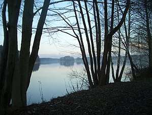
Groß Glienicker See
Groß Glienicker See is a lake in the states of Brandenburg and Berlin, Germany. At an elevation of 31.6 m, its surface area is 0.66 km². The border between the city of Potsdam and the city of Berlin runs in a north–south direction through the center of the lake, with the Potsdam locality of Groß Glienicke on the left shore and the Berlin locality of Kladow on the right shore.
| Groß Glienicker See | |
|---|---|
 | |
| Location | Brandenburg / Berlin |
| Coordinates | 52°28′0″N 13°7′0″E |
| Basin countries | Germany |
| Surface area | 0.66 km2 (0.25 sq mi) |
| Average depth | 6 m (20 ft) |
| Max. depth | 11 m (36 ft) |
| Shore length1 | 5.2 km (3.2 mi) |
| Surface elevation | 31.6 m (104 ft) |
| Settlements | Berlin, Potsdam |
| 1 Shore length is not a well-defined measure. | |
Geology
Together with the Sacrower See to the south and the Heiliger See in Potsdam, Glienicker See forms a chain of glacial lakes. It lacks a surface outlet and is almost entirely fed by groundwater.
The lake during the Cold War
The border between West Berlin and East Germany in the center of the lake was marked by buoys. The Berlin Wall on the west and south shores prevented access to or even a sight of the shore by East Germans. For those in West Berlin the lake was a popular place for swimming. One could swim (or in the winter walk over the ice) up to the buoys.
External links
- Nixdorf, B.; et al. (2004), "Groß Glienicker See", Dokumentation von Zustand und Entwicklung der wichtigsten Seen Deutschlands (in German), Berlin: Umweltbundesamt, p. 7