Gray Wolf Ridge
Gray Wolf Ridge is a spur of the northeastern Olympic Mountains in Washington's Olympic Peninsula. Arcing northeast from the Mount Deception - Needles - Mount Clark - Mount Walkinshaw massif, Gray Wolf Ridge is covered by alpine and subalpine forests up to the timberline, leaving the upper elevations of the ridge's six rocky peaks vegetated only by fragile alpine meadows. The ridge and its component mountains are markedly steep, as is its primary access route, the Maynard Burn Trail (#816) of Olympic National Forest. The higher, western segment of Gray Wolf Ridge lies within the boundary of Olympic National Park.
| Gray Wolf Ridge | |
|---|---|
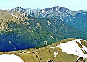 Gray Wolf Ridge (top) seen from Buckhorn Mountain | |
| Highest point | |
| Elevation | 7,218 ft (2,200 m) NGVD 29[1] |
| Coordinates | 47°52′11″N 123°12′51″W [2] |
| Geography | |
| Parent range | Olympic Mountains |
| Topo map | USGS Mount Deception |
Gray Wolf Mountain, at 7,218 feet (2,200 m) above sea level, is the ridge's highest summit. It was first climbed by Leigh B. Lint in 1928.[3] Other distinct peaks include '7076' (7076), Baldy (6797), Tyler Peak (6364), and Maynard Peak (5065), which forms the northeastern terminus of Gray Wolf Ridge. Gray Wolf River runs through the valley-bottom to the Ridge's north; Royal Creek and the Dungeness River flow through the valley along the Ridge's east and south.
References
- "Gray Wolf Ridge, Washington". Peakbagger.com.
- "Gray Wolf Ridge". Geographic Names Information System. United States Geological Survey.
- Majors, Harry M. (1975). Exploring Washington. Van Winkle Publishing Co. p. 70. ISBN 978-0-918664-00-6.