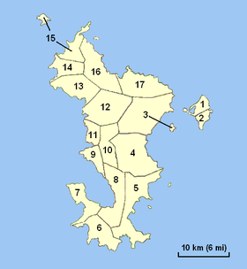
Grande-Terre (Mayotte)
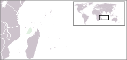
Grande-Terre (Maore or Nyambo Bole in Shimaore) is the main island of the French overseas region of Mayotte.[2] The island is located in the northern Mozambique Channel in the Indian Ocean, namely between northwestern Madagascar and northeastern Mozambique.
| Native name: Maore, Mahori | |
|---|---|
 Grande-Terre administrative | |
 | |
| Geography | |
| Location | Africa |
| Coordinates | 12.831887°S 45.149474°E |
| Archipelago | Comoros Island |
| Area | 368 km2 (142 sq mi) |
| Area rank | ~11th |
| Highest elevation | 660 m (2,170 ft) |
| Highest point | Mount Benara |
| Administration | |
| Largest settlement | Mamoudzou (pop. 53,022 (2009) 186,452[1]) |
| Demographics | |
| Population | (2010) |
| Pop. density | 499/km2 (1,292/sq mi) |
| Ethnic groups | Shimaore, Bushi, Arabs, Swahilis, French |
Its biggest city and prefecture is Mamoudzou. The territory is geographically part of the Comoro Islands, but the people of Mayotte chose to remain politically a part of France in the 1975 referendum. The territory is also known as Maore, the native name of its main island, especially by advocates of its inclusion in the Union of Comoros. In a 2009 referendum, 95.2% of the electorate approved accession to status of department. Mayotte became an overseas department on 31 March 2011 and an Outermost region of the European Union on 1 January 2014.
.jpg) Mayotte, Grande Terre
Mayotte, Grande Terre.jpg) The outskirts of Mayotte
The outskirts of Mayotte
References
- INSEE, Government of France. "INSEE Infos No 32" (PDF) (in French). Retrieved 2007-12-02.
- "Mayotte devient le 101e département français", Portail du Gouvernement, 4 April 2011, archived from the original on 25 July 2011,
C'est pourquoi Mayotte devient le 101e département français et le 5e département d'Outre-Mer et région d'Outre-Mer.