Gorong archipelago
The Gorom (formerly called Gorong) archipelago is a group of islands situated between the Watubela archipelago and Ceram in the Maluku Islands.
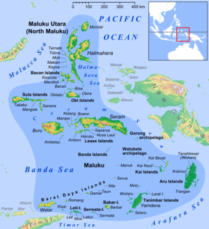 Gorong archipelago in the east of Maluku Islands | |
| Geography | |
|---|---|
| Location | South East Asia |
| Coordinates | 4°01′22″S 131°25′01″E |
| Total islands | 3 |
| Major islands | Gorom, Panjang and Manawoka |
| Administration | |
Indonesia | |
| Provinces | Maluku |
| Demographics | |
| Population | 27285 (2010) |
| Ethnic groups | Melanesian |
History
The Nagarakretagama, an Old Javanese eulogy to king Hayam Wuruk of Majapahit written in 1365, mentions "Gurun" amongst the tributary countries of the kingdom.[1]
The English naturalist Alfred Russel Wallace described the islands, which he called Goram, in chapter 25 of his 1869 book The Malay Archipelago.[2]
Islands
The archipelago has main three islands, plus further small offshore islands.[3]
- Gorom, the biggest island, with the villages of Miran (Miren) on the east coast, Ondor (Ondur) in the northwest and Hur on its southwestern coast.
- Panjang to the west of Gorong, with Wisalem village in its southern end.
- Manawoku in the south, with the villages of Arbau in the north, Amar and Derra, and Nama in the south.
Each of the three main islands now forms a separate district (kecamatan) within East Seram Regency of Maluku.
References
- Denys Lombard, Le carrefour javanais (1990)
- Wallace, Alfred Russel (1869). "25: Ceram, Goram, and the Matabello Islands". The Malay Archipelago: The land of the orang-utan, and the bird of paradise. A narrative of travel, with sketches of man and nature (1 ed.). Macmillan.
- Government of Indonesia Seram Bagian Timur map
This article is issued from Wikipedia. The text is licensed under Creative Commons - Attribution - Sharealike. Additional terms may apply for the media files.