Gongola River
The Gongola River is in northeastern Nigeria, the principal tributary of the Benue River. The upper course of the river as well as most of its tributaries are seasonal streams, but fill rapidly in August and September. The Gongola rises on the eastern slopes of the Jos Plateau and falls to the Gongola Basin, running northeasterly until Nafada. At one time, the Gongola continued from here in the northeast direction to Lake Chad. Today it turns south and then southeast until it joins the Hawal River, its main tributary.[1] The Gongola then runs south to the Benue river, joining it opposite the town of Numan.[2]
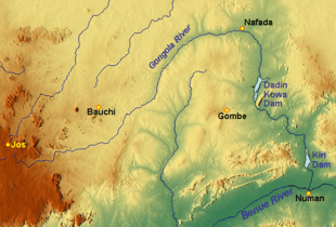
The lower reaches of the river are impounded by the Dadin Kowa Dam near Gombe, and lower down by the Kiri Dam. After the Kiri dam was constructed, downstream flood peaks dropped from 1,420 cubic metres per second (50,000 cu ft/s) to 1,256 cubic metres per second (44,400 cu ft/s), while flows in dryer seasons increased from 5.7 cubic metres per second (200 cu ft/s) to 21 cubic metres per second (740 cu ft/s). The river downstream from the dam also narrowed and became less winding, with fewer separate channels.[3]
References
- Reuben K. Udo (1970). Geographical regions of Nigeria. University of California Press. p. 150.
- "Gongola River". Encyclopædia Britannica. Retrieved 2010-05-21.
- Tukur A.L., Mubi A.M. (February 2002). "Impact of Kiri dam on the lower reaches of river Gongola, Nigeria". GeoJournal, Volume 56, Number 2. Springer. pp. 93–96(4). Retrieved 2010-05-21.