Glossary of meteorology
This glossary of meteorology is a list of terms and concepts relevant to meteorology and atmospheric science, their sub-disciplines, and related fields.
| Part of a series on |
| Weather |
|---|
|
|
 |
|
Atmospheric physics |
| Meteorology |
|---|
|
Weather (category) · (portal) |
| Climatology |
|
Climate (category) |
| Glossaries |
| Glossary of meteorology · Glossary of tropical cyclone terms · Glossary of tornado terms · Glossary of climate change |
A
- advection
- The horizontal transport of some property of the atmosphere or ocean, such as thermal energy, humidity, or salinity. In the context of meteorology, the related term convection generally refers to vertical transport.
- actinoform
- Describing a collection of low-lying, radially structured clouds with distinct shapes (resembling leaves or wheels in satellite imagery), and typically organized in extensive mesoscale fields over marine environments. They are closely related to and sometimes considered a variant of stratocumulus clouds.
- actinometer
- A scientific instrument used to measure the heating power of radiation, particularly solar radiation.
- adiabatic process
- Any idealized hypothetical process by which energy is transferred between a thermodynamic system and its surroundings only as work, without a corresponding transfer of heat or mass. In the context of meteorology, the assumption of adiabatic isolation is often used to explain the processes of adiabatic heating and adiabatic cooling, which involve changes in temperature as a parcel of air is compressed or expanded by interaction with its surroundings.
- aerobiology
- The branch of biology that studies airborne organic particles, such as bacteria, viruses, fungal spores, pollen grains, and very small insects, which are passively transported by the air.
- aerography
- The production of weather charts.
- aeronomy
- The branch of meteorology that studies the upper regions of the Earth's or other planetary atmospheres, specifically their atmospheric motions, chemical compositions and properties, and interactions with the other parts of the atmosphere and with space.
- aerosol
- A suspension of fine solid particles or liquid droplets in air or another gas. Examples of natural aerosols include mist, clouds, fog, and dust.
- ageostrophy
- air current
- Any concentrated area of winds that develops due to differences in pressure and/or temperature between adjacent air parcels. They are generally divided into horizontal and vertical currents and exist at a variety of scales and in various layers of the atmosphere.
- air mass
- A volume of air defined by its temperature and content of water vapor.
- air parcel
- In fluid dynamics, any amount of air that remains identifiable throughout its dynamic history while moving with an associated air flow.
- air-mass thunderstorm
- Any thunderstorm that is generally weak and usually not severe. Such storms move relatively slowly, are short-lived, and often exist only as single cells (rather than in long continuous lines or complexes), but may still produce lightning and heavy rainfall. They derive their energy from solar radiation and commonly develop in temperate zones during summer afternoons.
- Alberta clipper
- almanac
- An annual publication of calendar events.
- altocumulus castellanus
- altocumulus
- altostratus
- American Meteorological Society (AMS)
- anabatic wind
- anemometer
- A scientific instrument used to measure wind speed.
- annular tropical cyclone
- anticyclone
- Any large-scale air mass characterized by outward spiraling winds which circulate around a strong center of high atmospheric pressure. Surface-based anticyclones generally bring about cool, dry air and clear skies and are often implicated in weather phenomena such as fog and haze. Contrast cyclone.
- anticyclonic rotation
- anticyclonic storm
- anticyclonic tornado
- anticyclogenesis
- The development or strengthening of an anticyclonic circulation in the atmosphere, which may result in the formation or maintenance of a high-pressure area. Contrast cyclogenesis.
- arcus cloud
- Arctic cyclone
- Atlantic hurricane
- A tropical cyclone (locally known as a hurricane) that forms in the Atlantic Ocean and achieves one-minute maximum sustained winds exceeding 74 mph (119 km/h; 64 kn). Most of these storms occur between June 1 and November 30 each year, a time period referred to as the Atlantic hurricane season.
- atmosphere
- The various layers of gases surrounding the Earth and held in place by gravity. The Earth's atmosphere is the origin of the weather phenomena studied in meteorology. Atmospheric composition, temperature, and pressure vary across a series of distinct sublayers including the troposphere and stratosphere.
- atmospheric circulation
- The global-scale movement of air masses within the Earth's atmosphere. All meteorological phenomena are a consequence of the atmospheric circulation, which manifests as a network of both latitudinal and longitudinal "cells" of convective activity; together with ocean circulation, these cells are the primary means by which thermal energy from the Sun is redistributed across the Earth's surface.
- atmospheric convection
- atmospheric density (ρ)
- The density (mass per unit volume) of the Earth's atmosphere. Atmospheric density generally decreases proportionally with elevation above sea level, and also tends to vary with changes in atmospheric pressure, temperature, and humidity. According to the International Standard Atmosphere, at a pressure of 1 atm and a temperature of 15° C, air has a density of approximately 1.225 kilograms per cubic metre (kg/m3), about 1⁄1000 the density of liquid water.
- atmospheric model
- atmospheric pressure (p)
- The pressure exerted by the Earth's atmosphere. In most circumstances atmospheric pressure is closely approximated by the hydrostatic pressure caused by the weight of the air above the measurement point, and therefore decreases proportionally with elevation above sea level. The average atmospheric pressure at sea level on Earth is equal to approximately 1 standard atmosphere (atm), which is defined as exactly 101,325 pascals (760 mmHg).
- atmospheric river
- atmospheric science
- The collective of scientific disciplines that studies the Earth's atmosphere and its processes, including the effects other systems have on the atmosphere and those the atmosphere has on other systems. Meteorology and climatology are sub-disciplines.
- atmospheric sounding
- A measurement of the vertical distribution of physical properties through an atmospheric column, usually including pressure, temperature, wind speed and direction, moisture content, ozone concentration, and pollution, among others.
- atmospheric temperature
- atmospheric thermodynamics
- atmospheric tide
- autumn
- avalanche
- Aviation Area Forecast (FA or ARFOR)
- A former message product of the U.S. National Weather Service issued to provide information to pilots and aviation routes about weather conditions across a large regional area within the United States. FAs were issued three times daily, valid for 18 hours, and covered an area the size of several states. They were replaced by Graphic Area Forecasts (GFAs) in 2017.
B
- backscatter
- The diffuse reflection of waves, particles, or signals back to the same direction from which they originated. Backscattering is the principle underlying all weather radar systems, which can distinguish radar returns backscattered from target aerosols such as raindrops and snowflakes because the strength of the returns depends largely on the size and reflectivity of the targets.
- ball lightning
- banana belt
- Any segment of a larger geographic region that typically experiences warmer temperatures than the region as a whole, especially during the local winter season, which may prove favorable for agricultural production.
- barbs
- barograph
- A scientific instrument used to measure and record changes in atmospheric pressure over time.
- baroclinity
- A measure of the misalignment between a pressure gradient and a density gradient in a stratified fluid such as the atmosphere. In the context of meteorology, a baroclinic atmosphere is one in which atmospheric density depends on both temperature and pressure, in contrast to a barotropic atmosphere, in which density depends only on pressure. Areas of high atmospheric baroclinity are generally found in the temperate and polar latitudes and are characterized by the frequent formation of cyclones.
- barotropity
- The close alignment between a pressure gradient and a density gradient in a stratified fluid such as the atmosphere. In the context of meteorology, a barotropic atmosphere is one in which atmospheric density depends only on pressure and is more or less independent of temperature, in contrast to a baroclinic atmosphere. Unlike liquids, gaseous fluids such as the air in the atmosphere are generally not barotropic, but the assumption of barotropity can nonetheless be useful in modeling fluid behavior. Tropical latitudes are more nearly barotropic than the mid-latitudes because air temperature is more nearly horizontally uniform in the tropics.
- barometer
- A scientific instrument used to measure atmospheric pressure.
- Beaufort scale
- Bernoulli's principle
- A principle of fluid dynamics which states that an increase in the speed of a moving fluid occurs simultaneously with a decrease in the pressure exerted by the fluid or in the fluid's potential energy.
- Bishop's ring
- black ice
- A thin, nearly transparent coating of glaze ice on a solid surface, especially a road or walkway, which because of its transparency is often practically invisible and therefore presents a significant hazard to drivers and pedestrians.
- blizzard
- A severe snowstorm characterized by strong sustained winds of at least 35 mph (56 km/h) and typically lasting three hours or more. They can have an immense size, covering hundreds or thousands of square miles, and occur most often in temperate, polar, or mountainous regions during the winter.
- block
- A nearly stationary pattern in the atmospheric pressure field overlying a large geographic area, which effectively "blocks" or diverts the movements of cyclones and other convective systems. These blocks can remain in place for days or weeks, causing the areas affected by them to experience the same kind of weather for extended periods of time.
- blowing dust or sand
- blowing snow
- Snow blown about by wind, either from falling snow or snow lifted from the surface, to a height of at least 2 metres (6.6 ft), reducing visibility. It is a defining characteristic of blizzards.
- bounded weak echo region (BWER)
- bow echo
- A characteristic radar return from a mesoscale convective system that is shaped like an archer's bow and usually associated with squall lines or lines of convective thunderstorms. The distinct bow shape is a result of the focusing of a strong flow at the rear of the system. Especially strong bow echoes may develop into derechos.
- breeze
- brightband
- Bulk Richardson Number (BRN)
- A dimensionless ratio related to the consumption of turbulence divided by the shear production of turbulence (the generation of kinetic energy caused by wind shear). It is an approximation of the Gradient Richardson Number.
- bushfire
- See wildfire.
- Buys Ballot's law

A radar image showing a distinct bow echo in a line of thunderstorms over Kansas City, Missouri
C
- Canadian Meteorological and Oceanographic Society (CMOS)
- The national society of individuals and organizations dedicated to advancing atmospheric and oceanic sciences and related environmental disciplines in Canada, officially constituted in 1967.
- Canadian Meteorological Centre (CMC)
- capping inversion
- castellanus
- A cloud species that displays at least in its upper part cumuliform protuberances resembling the turrets of a castle, giving a crenellated aspect.
- ceiling
- A measure of the height above the Earth's surface of the base of the lowest layer of clouds or obscuring phenomena that covers more than half of the sky (more than four oktas). An "unlimited" ceiling means either that the sky is mostly free of cloud cover or that the clouds are sufficiently high so as not to impede aircraft operation by visual flight rules.
- ceiling balloon
- ceiling projector
- ceilometer
- An instrument that uses a laser or other light source to determine the height of a cloud ceiling or cloud base or to measure the concentration of aerosols within the atmosphere.
- Center for Analysis and Prediction of Storms (CAPS)
- central dense overcast (CDO)
- The large, centralized, contiguous area of thunderstorms surrounding the rotational center of a strong tropical or subtropical cyclone. When a cyclone reaches sufficient intensity, a distinguishable eye may develop within the CDO. The strongest winds and heaviest rainfall are usually found beneath the coldest cloud tops in the CDO.
- chinook wind
- cirrocumulus
- cirrostratus
- cirrus (Ci)
- A genus of cloud characterized by thin, wispy, feather-like strands that appear white or light grey in color and form at very high altitudes, usually between 5 and 13.7 km (16,000 and 45,000 ft) above sea level. Cirrus clouds often develop from the outflow of cumulonimbus clouds in advance of fronts or thunderstorms, and therefore may indicate the imminent arrival of precipitation.
- clear ice
- A type of solid precipitation which forms when relatively large drops of water are supercooled into a dense, transparent coating of ice without air or other impurities. It is similar to glaze and hard rime and, when formed on the ground, is often called black ice.
- clear-air turbulence
- climate
- The statistics of weather in a given region over long periods of time, measured by assessing long-term patterns of variation in temperature, atmospheric pressure, humidity, wind, precipitation, and other meteorological variables. The climate of a particular location is generated by the interactions of the atmosphere, hydrosphere, cryosphere, lithosphere, and biosphere and strongly influenced by latitude, altitude, and local topography. Climates are often classified according to the averages or typical ranges of different variables, most commonly temperature and precipitation.
- climatology
- A branch of the atmospheric sciences that studies climate, defined as weather conditions averaged over an extended to indefinite period of time. Climatology incorporates aspects of oceanography, geology, biogeochemistry, and the related field of meteorology to understand the long-term dynamics of climate-influencing phenomena and to produce climate models which can be used to estimate past climates and predict future climates.
- cloud
- An aerosol consisting of a visible mass of minute liquid droplets, frozen crystals or other particles suspended in the atmosphere. Water or various other chemicals may compose the droplets and crystals. On Earth, clouds are formed as a result of the saturation of an air mass when it is cooled to its dew point or when it gains sufficient moisture (usually in the form of water vapor) from an adjacent source to raise the dew point to the ambient temperature. There are many different types of clouds, which are classified and named according to their shape and altitude.
- cloud atlas
- A pictorial key to the classification and nomenclature of clouds.
- cloud base
- The lowest altitude of the visible portion of a cloud.
- cloud cover
- The obscuration of all or part of the sky by clouds as observed from a particular location, or the specific fraction of the sky obscured by clouds as measured in oktas.
- cloud drop effective radius
- cloud genus
- See cloud type.
- cloud iridescence
- A type of photometeor consisting of colorful iridescent patterns appearing most commonly near the semi-transparent edges of thin clouds such as cirrus and altocumulus that are in the general proximity of the Sun or Moon. They are caused by the diffraction of sunlight or moonlight by thin, uniform layers of very small water droplets or ice crystals.
- cloud species
- Any of a set of 14 Latin terms used to describe the shape and internal structure of tropospheric clouds. Cloud species are subdivisions of cloud genera and are themselves further subdivided into cloud varieties.
- cloud tag
- cloud type
- Any of a set of Latin names used to classify and identify clouds occurring in the troposphere, typically by characteristics such as their altitude, shape, and convective activity. A set of 10 or 12 traditional cloud types defined by the World Meteorological Organization and further subdivided into cloud species and cloud varieties is widely used in meteorology. Other classification systems have proposed many additional types.
- cloud variety
- cloudburst
- col
- The point of intersection of a trough and a ridge in the pressure pattern of a weather map. It generally takes the shape of a saddle in which the air pressure is slightly higher than that within the low-pressure regions but still lower than that within the anticyclonic zones.
- cold front
- A type of front located at the leading edge of a cooler air mass as it replaces a warmer air mass. Cold fronts lie within a sharp surface trough of low pressure and the temperature difference between the air masses they separate can exceed 30 °C (86 °F). When enough moisture or instability is present, lines of rain or thunderstorms may accompany the boundary as it moves. In surface weather analysis, cold fronts are symbolized by a blue line with triangles pointing in the direction of travel.
- cold wave
- A period of weather characterized by excessively low temperatures, which may or may not also be accompanied by changes in humidity. Very cold weather is often only referred to as a cold wave if the temperature, or the rate at which the temperature decreases within a given time period, is abnormal relative to the typical climate for a given location during a given season. Contrast heat wave.
- cold-core low
- Colorado low
- A type of low-pressure area that forms in southeastern Colorado or northeastern New Mexico, in the United States, and then proceeds to move east across the Great Plains, often producing heavy snow and ice when occurring in the winter.
- convection
- See atmospheric convection.
- convective available potential energy (CAPE)
- convective condensation level
- convective inhibition (CIN)
- convective instability
- The inability of an air mass to resist vertical motion. In a stable atmosphere vertical movement of air is generally difficult, whereas in an unstable atmosphere vertical disturbances can be quite exaggerated, resulting in turbulent airflow and convective activity that may lead to extensive vertical clouds, storms, and severe weather.
- convective outlooks
- convective storm detection
- convergence
- convergence zone
- corona
- An optical phenomenon consisting of apparent concentric, pastel-colored rings around a bright celestial object (such as the Sun or the Moon), which are produced by the diffraction of light by individual water droplets or sometimes small ice crystals in a cloud or on a foggy glass surface. Coronae differ from halos in that the latter are formed by refraction from comparatively large particles.
- crepuscular rays
- crosswind
- Any wind that moves in a direction that is perpendicular to the direction of travel of a reference object, such as an airplane.
- Crow instability
- An inviscid line-vortex instability most commonly observed in the skies behind large aircraft such as the Boeing 747. It occurs when the wingtip vortices interact with contrails from the engines, producing characteristic visual distortions in the shapes of the contrails.
- cumulonimbus
- cumulus (Cu)
- A genus of cloud characterized by low-level "puffy" or "cotton-like" forms with flat bases (generally opaque white in color but sometimes with grey undersides), which occur individually or multiply in a variety of distinct subforms, usually at altitudes less than 2 km (6,600 ft) above sea level. Cumulus clouds normally produce little or no precipitation, but can develop into precipitation-bearing clouds such as cumulonimbus when influenced by atmospheric instability, moisture, and temperature gradients.
- cumulus congestus
- cumulus humilis
- cumulus mediocris
- cyclone
- Any large-scale air mass characterized by inward spiraling winds which circulate around a strong center of low atmospheric pressure. Cyclones can form over land or water, can vary in size from mesocyclones such as tornadoes to synoptic-scale phenomena such as tropical cyclones and polar vortices, and may transition between tropical, subtropical, and extratropical phases. Contrast anticyclone.
- cyclonic rotation
- cyclogenesis
- The development or strengthening of a cyclonic circulation in the atmosphere. Cyclogenesis may refer to a number of different processes that occur under a variety of conditions and at a variety of scales, all of which result in the formation of some sort of cyclone; for instance, tornadoes are a type of mesocyclone whose development may be variously described as cyclogenesis or, more specifically, tornadogenesis. Contrast anticyclogenesis.

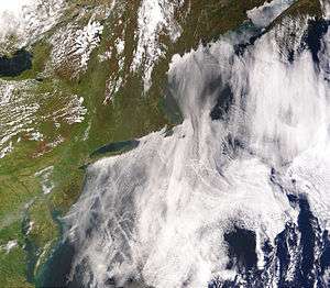
Very large air masses (and the clouds within them) spiral counterclockwise around a strong center of low atmospheric pressure in this extratropical cyclone over Iceland
D
- dark adaptor goggles
- A type of specialized eyewear used by meteorologists and astronomers for adapting the eyes to the dark prior to an observation made at night, or for aiding with identification of clouds during bright sunshine or when there is a glare from snow.
- dawn
- daytime
- The period of the day between sunrise and sunset, during which any given point on the Earth experiences natural illumination from especially direct sunlight, known as daylight.
- dBZ
- debris cloud
- See tornado debris signature.
- deformation
- The rate of change of shape of a fluid body such as an air mass. This quantity is very important in the formation of atmospheric fronts, in the explanation of cloud shapes, and in the diffusion of materials and properties through the atmosphere.
- dense fog
- depression
- See low-pressure area.
- derecho
- dew
- Liquid water droplets that commonly appear on thin, exposed surfaces in the morning or evening due to the condensation of atmospheric moisture on radiatively cooled surfaces. When temperatures are low enough, the water droplets freeze into ice particles known as frost. <dt class="glossary " id="dew point (td)" style="margin-top: 0.4em;">dew point (Td) <dt class="glossary " id="dew point depression (t–td)" style="margin-top: 0.4em;">dew point depression (T–Td)
- The difference between the actual temperature and the dew point at a certain altitude in the atmosphere. A small dew point depression indicates more moisture and higher relative humidity, which in the lower troposphere can result in low cloud bases and lifted condensation levels, which are important factors contributing to the development of severe thunderstorms.
- Diablo wind
- diamond dust
- A ground-level cloud composed of tiny ice crystals. Because it generally forms in sub-freezing temperatures beneath otherwise clear or nearly clear skies, diamond dust is sometimes referred to as clear-sky precipitation.
- diffluence
- diffuse sky radiation
- disdrometer
- A scientific instrument used to measure the size distribution and velocity of falling hydrometeors such as raindrops.
- diurnal temperature variation
- Dobson unit (DU)
- A unit of measurement used to describe the quantity of a trace gas (primarily atmospheric ozone concentrations) present in a vertical column of the atmosphere. It is defined as the thickness (in units equivalent to 10 μm) of the layer of pure gas which would be formed if all of the gas molecules in the column could be collected on the surface at standard temperature and pressure.
- doldrums
- See Intertropical Convergence Zone.
- Doppler on Wheels (DOW)
- Doppler weather radar
- downburst
- A surface-level wind system that emanates from an elevated point source and blows radially in all directions upon making contact with the ground. Downbursts are created when rain-cooled air descends rapidly, and can produce very strong damaging winds. They are often confused with tornadoes, though a tornado causes air to move inward and upward whereas a downburst directs it downward and outward. Microbursts, macrobursts, and heat bursts are all types of downburst.
- downdraft
- drifting snow
- drizzle
- A type of light precipitation consisting of liquid water droplets which are smaller than ordinary raindrops, generally less than 0.05 millimetres (0.002 in) in diameter and falling at a rate of less than 1 millimetre (0.04 in) per day.
- drought
- Any prolonged period of below-average precipitation in a given region that results in shortages in the local water supply, whether of atmospheric, surface water, or ground water. Droughts can last for months or even years, and may be declared after as few as 15 days; annual or seasonal decreases in precipitation, such as dry seasons in the tropics, are sometimes called droughts, though a true drought is by definition abnormal or irregular. Drought conditions result from the confluence of a wide variety of climatic factors and may be exacerbated by hot temperatures; in turn, droughts may increase the likelihood of wildfires.
- dry lightning
- Lightning associated with a dry thunderstorm.
- dry line
- dry microburst
- dry punch
- Meteorological slang for a synoptic-scale or mesoscale weather process. A dry punch that occurs near the Earth's surface may result in a dry line bulge, whereas a dry punch aloft may increase the potential for severe thunderstorms.
- dry season
- dry thunderstorm
- A thunderstorm that produces thunder and lightning but in which most or all of its precipitation evaporates before reaching the ground. Dry thunderstorms occur necessarily in dry conditions, and their lightning strikes, sometimes referred to as dry lightning, are a major cause of wildfires.
- dual polarization weather radar
- dusk
- dust devil
- dust storm
- A meteorological phenomenon characterized by very strong winds that blow dust-filled air over an extensive area. Dust storms arise when a gust front or other strong wind blows loose dirt, sand, and/or small rocks from a dry surface into the atmosphere, drastically reducing visibility. Though the term is sometimes restricted to storms occurring over normally arable land suffering from drought, it is also used interchangeably with sandstorm and haboob.
E
- echo
- On a radar display, the appearance of the radio signal that is scattered or reflected by a target. The distinct characteristics of a radar echo can be used to identify the distance and velocity of the target with respect to the signal source as well as the target's size, shape, and composition.
- eddy
- The swirling motion of a fluid and the reverse current created when the flow regime experiences turbulence, such as when an obstacle blocks part of the path of flow.
- Ekman layer
- The layer in a fluid in which there is a force balance between the pressure-gradient force, the Coriolis force, and turbulent drag. Ekman layers occur in both the atmosphere and the ocean.
- Ekman number
- Ekman spiral
- Ekman transport
- energy-helicity index (EHI)
- El Niño
- El Niño–Southern Oscillation
- emagram
- One of four thermodynamic diagrams used to display temperature lapse rate and moisture content profiles in the atmosphere. Emagrams have axes of temperature (T) and pressure (p). Temperature and dew point data from radiosondes are plotted on these diagrams to allow calculations of convective stability or convective available potential energy.
- Enhanced Fujita scale (EF scale)
- entrainment
- Environment and Climate Change Canada
- Environmental Modeling Center (EMC)
- Environmental Science Services Administration (ESSA)
- The predecessor agency (1965–1970) to the National Oceanic and Atmospheric Administration (1970–present).
- equivalent temperature ()
- equivalent potential temperature ()
- Eulerian equations
- European windstorm
- explosive cyclogenesis
- extratropical cyclone
- extreme weather
- Any weather that is unexpected, unusual, unpredictable, unseasonal, or especially severe (i.e. weather at the extremes of an historical distribution).
- eye
- A typically circular region at the center of a strong tropical cyclone that is the location of the storm's lowest barometric pressure. The eye is usually characterized by light winds, clear skies, and mostly calm weather, in stark contrast to the severe weather that occurs in the surrounding eyewall and the rest of the storm.
- eyewall


F
- fall wind
- See katabatic wind.
- Fata Morgana
- fetch
- The length of water over which a given wind blows. Fetch length and wind speed together determine the size of the waves that form on the surface of a body of water; the longer the fetch and the stronger the wind, the more wind energy is imparted to the water surface and the larger the resulting sea state.
- field mill
- A scientific instrument used to measure the strength of electric fields in the atmosphere.
- fire whirl
- A whirlwind induced by a fire and often at least partially composed of flame or ash. They are usually associated with very large wildfires. Fire whirls are seldom classified as true tornadoes, as their vorticity usually derives from turbulent surface winds and heat-induced lifting rather than from a tornadic mesocyclone aloft.
- firestorm
- A very large wildfire or other conflagration which because of its intensity is able to create and sustain its own storm-force winds. Firestorms develop when a convective updraft of hot air rising from the burning area draws in strong wind gusts from all directions, which supply the fire with additional oxygen and thereby induce further combustion. They are often associated with flammagenitus clouds and fire whirls.
- flammagenitus
- flash flood
- Any flood which very rapidly inundates low-lying areas such as washes, rivers, dry lakes, and basins, especially one which recedes again in less than six hours. Flash flooding can be caused by heavy rain associated with severe weather, large amounts of meltwater from melting ice or snow, or the sudden collapse of a natural ice or debris dam.
- flash freezing
- The process by which objects such as liquid hydrometeors are cooled below their freezing point very quickly, typically upon being subjected to extremely cold atmospheric temperatures or by making contact with a frozen surface.
- flood
- An overflow of water which submerges land that is usually dry. Flooding may occur when water bodies such as rivers, lakes, or oceans escape their boundaries by overtopping or puncturing levees, or it may occur when precipitation accumulates on saturated ground more rapidly than it can either infiltrate or run off.
- flumen
- fog
- A visible aerosol of minute water droplets or ice crystals that is suspended in the air at or near the Earth's surface. Fog is often considered a type of low-lying cloud and is heavily influenced by local topography, nearby bodies of water, and wind conditions.
- fogbow
- föhn wind
- A type of warm, dry, downslope wind that occurs in the lee of a mountain range.
- forward-flank downdraft (FFD)
- fractus (Fr)
- frazil ice
- freezing drizzle
- freezing fog
- freshet
- 1. A springtime thaw of snow and ice that produces a significant local inundation of rivers, streams, small watercourses, and floodplains as the snowpack melts within a watershed.
- 2. Any temporarily inundated or rapidly flowing watercourse or newly created (and often ephemeral) drainage channel resulting from snowmelt.
- freezing rain
- Liquid droplets of rain that become supercooled while falling through a sub-freezing air mass and then freeze upon impact with any surface they encounter; the resulting glaze ice can accumulate to a thickness of several centimeters. Unlike mixed rain and snow, ice pellets, and hail, freezing rain exists entirely as a liquid until it hits a surface.
- front
- A boundary separating two masses of air of different densities and usually also of different temperatures and humidities. Weather fronts are the principal cause of meteorological phenomena outside the tropics, often bringing with them clouds, precipitation, and changes in wind speed and direction as they move. Types of fronts include cold fronts, warm fronts, and occluded fronts.
- frontogenesis
- The meteorological process by which a weather front is created, usually as a result of the narrowing of one or more horizontal temperature gradients across the boundary between two adjacent air masses. Contrast frontolysis.
- frontolysis
- The dissipation or weakening of an atmospheric weather front. Contrast frontogenesis.
- frost
- A very thin layer of ice crystals on a solid surface, typically restricted to that which forms when water vapor in an atmosphere whose temperature is above freezing comes into contact with a surface whose temperature is below freezing. Frost may exhibit a great variety of forms.
- Fujita scale
- funnel cloud
- A funnel-shaped cloud associated with a rotating column of air and protruding from the base of a parent cloud but not reaching the ground or a water surface. Funnel clouds form most frequently in association with supercell thunderstorms and often develop into tornadoes.
G
- gale
- A strong surface wind, typically used as a descriptor in nautical contexts. Gales are variously defined based on their speed; in the modern Beaufort scale, sustained winds of 28–33 kn (52–61 km/h; 32–38 mph), Beaufort number 7, are designated as near gales and those of 34–47 kn (63–87 km/h; 39–54 mph), spanning Beaufort numbers 8 and 9, as gales.
- gale warning
- gap wind
- geopotential height
- A measure of the vertical distance or altitude above mean sea level that accounts for variations in gravitational potential as altitude and latitude change. In meteorology and atmospheric science, geopotential height is often used in place of ordinary altitude when calculating the primitive equations in numerical weather prediction and when creating atmospheric models.
- geostrophic wind
- The theoretical wind that would result from an exact balance between the Coriolis force and the pressure gradient force (known as geostrophic balance). The true wind almost always differs from the geostrophic wind due to the influence of other forces such as friction from the ground.
- glaze
- GPS meteorology
- A type of observational meteorology that interprets the effects of atmospheric properties such as total precipitable water vapor on the propagation of Global Positioning System (GPS) radio signals to derive information about the state of the local atmosphere.
- graupel
- A type of precipitation that forms when supercooled water droplets are collected and freeze on falling snowflakes, forming balls of rime 2–5 mm (0.079–0.197 in) in diameter. Graupel is distinct from hail, small hail, and ice pellets.
- Great Salt Lake effect
- A lake-effect snow that occurs in the lee of Utah's Great Salt Lake.
- grease ice
- green flash
- ground blizzard
- A weather condition that occurs when loose snow or ice on the ground is lifted and blown into the air by strong winds. This can create low-visibility conditions even in the absence of precipitation.
- ground truth
- Information, such as local weather conditions, provided by direct observation (i.e. empirical evidence) as opposed to information provided by inference.
- gust
- A brief, sudden increase in the speed of the wind, usually lasting less than 20 seconds. Gusts are more transient than squalls and are followed by a lull or slowing of the wind speed. They are generally only reported by weather stations when the maximum wind speed exceeds the average wind speed by at least 10–15 knots (12–17 mph).
- gust front
- See outflow boundary.
- gustnado
H
- haboob
- hail
- A type of solid precipitation that consists of balls or irregular lumps of ice usually 5–150 mm (0.20–5.91 in) in diameter, each of which is called a hailstone. Hail formation requires environments with strong, upward motion of air and low altitudes at which water freezes, which makes it possible within most thunderstorms. It is distinct from graupel and sleet or ice pellets.
- hailstorm
- Haines Index
- A weather index that measures the potential for dry, unstable air to contribute to the development of large or erratic wildland fires. The index derives from data on the stability and moisture content of the lower atmosphere and is calculated over three ranges of atmospheric pressure.
- halo
- hard rime
- A type of rime consisting of opaque, granular masses of ice deposited primarily on vertical surfaces by freezing fog. Hard rime is more compact and amorphous than soft rime and usually develops on windward surfaces exposed to high wind speeds and air temperatures between −2 and −8 °C (28 and 18 °F).
- Harmattan
- haze
- hazardous seas warning
- hazardous seas watch
- heat burst
- heat index (HI)
- A meteorological index that posits the apparent temperature perceived by the average human being who is exposed to a given combination of air temperature and relative humidity in a shaded area. For example, when the air temperature is 32 °C (90 °F) with 70% relative humidity, the heat index is 41 °C (106 °F).
- heat lightning
- heat wave
- A period of weather characterized by excessively high temperatures, which may or may not be accompanied by high humidity or by drought. Very hot weather is often only referred to as a heat wave if the temperature is abnormal relative to the typical climate for a given location during a given season. Contrast cold wave.
- heavy snow warning
- A type of weather warning formerly issued by the U.S. National Weather Service to alert areas in which a high rate of snowfall (generally 6 in (15 cm) or more in 12 hours) was occurring or was forecast. The warning was replaced by the Winter Storm Warning for Heavy Snow beginning with the 2008–09 winter storm season.
- helicity
- high-pressure area
- hodograph
- A vectorial visual representation of the movement of a body or a fluid, with the position of any data plotted on it proportional to the velocity of the moving particle. In the context of meteorology, hodographs are used to plot winds from atmospheric soundings: for a given vector, wind direction is indicated by the angle from the center axis and wind speed by the distance from the center.
- hook echo
- horseshoe vortex
- humidity
- A measure of the amount of water vapor present in a parcel of air. By quantifying the saturation of the air with moisture, humidity indicates the likelihood of precipitation, dew, or fog occurring. The amount of water vapor needed to achieve full saturation increases as the air temperature increases. Three primary measurements of humidity are widely employed in meteorology: absolute, relative, and specific.
- humidex
- humilis
- hurricane
- The local name for a tropical cyclone that occurs in the Atlantic Ocean or northeastern Pacific Ocean and achieves one-minute maximum sustained winds exceeding 74 mph (119 km/h; 64 kn).
- hurricane hunters
- huaico
- A mudslide or flash flood caused by torrential rainfall occurring high in the Andes mountains of South America, especially during the weather phenomenon known as El Niño.
- hydrometeor
- Any particulate of liquid or solid water within the atmosphere, encompassing all types of precipitation, formations due to condensation such as clouds and haze, and particles blown from the Earth's surface by wind such as blowing snow and sea spray.
- hydrometeorology
- A branch of meteorology and hydrology that studies the transfer of water and energy between land surfaces and the lower atmosphere.
- hydrosphere
- The combined mass of all solid, liquid, and gaseous forms of water found on, beneath, or above the surface of the Earth, including all oceans, lakes, streams, groundwater, atmospheric water vapor, snow, ice caps, and glaciers.
- hydrostatic equilibrium
- hygrometer
- A scientific instrument used to measure humidity.
- hygroscopy
- hypsometer
- A scientific instrument used to measure height or elevation, either by trigonometry or by the principle that atmospheric pressure influences the boiling point of liquids.

Numerous hailstones accumulated on the ground following a hailstorm
I
- ice
- Water frozen into a solid state. Ice is abundant on Earth's surface and in the atmosphere and plays a major role in Earth's water cycle and climate. Its natural occurrence in weather phenomena takes many forms, including snowflakes, hail, frost, icicles, and ice spikes.
- iceberg
- ice accretion indicator
- ice crystals
- ice fog
- ice pellets
- ice spike
- A rare ice formation that consists of a long, slender projection of ice extending upward from the surface of a frozen body of water, often in the shape of an inverted icicle.
- ice storm
- A type of winter storm characterized by freezing rain which results in the accumulation of at least 6.4 millimetres (0.25 in) of ice on exposed surfaces.
- icicle
- A long, slender spike of ice formed when water dripping or falling from an object freezes.
- incus
- Indian summer
- inflow
- The influx of heat and moisture into a storm system from the surrounding environment. The inflow of parcels of warm, moist air drives and sustains most types of storms, including thunderstorms and tropical cyclones. Contrast outflow.
- instrument flight rules (IFR)
- International Standard Atmosphere (ISA)
- A static atmospheric model of the variations in temperature, pressure, density, and viscosity over a wide range of altitudes within the Earth's atmosphere, established as an international standard by the International Organization for Standardization in order to provide a common reference for atmospheric variables relevant to meteorology and atmospheric science.
- Intertropical Convergence Zone (ITCZ)
- irisation
- See cloud iridescence.

Icicles hanging from the eaves of a building
J
- jet stream
- A narrow, fast-flowing, meandering air current primarily occurring in the upper part of the troposphere, at altitudes above 9 km (30,000 ft), and usually flowing from west to east. The Northern and Southern Hemispheres each have a polar jet and a subtropical jet; low-level jets and other types of jet streams can form under certain conditions.
K
- K-index
- katabatic wind
- A wind that carries high-density air from a higher elevation down a slope under the force of gravity, usually at speeds of the order of 10 kn (19 km/h) or less but occasionally at much higher speeds.
- Kelvin temperature scale
- Kelvin–Helmholtz instability
- khamsin
- The local name for a dry, hot, seasonal wind, often carrying large quantities of dust or sand, that occurs in the deserts of Egypt, Israel, Palestine, and Jordan. Compare haboob, harmattan, sirocco, and simoom.
- kinematics
- A branch of classical mechanics that describes the motion of points, bodies, and systems of bodies without considering the forces that caused the motion.
- Köppen climate classification

L
- Lagrangian equations
- La Niña
- lake-effect snow
- A weather phenomenon produced when a cold air mass moves across long expanses of warmer lake water, which causes the lowest layers of air to pick up warm water vapor from the lake, rise through the upper layers, freeze and then precipitate on the lake's leeward shores. In combination with orographic lift, the effect produces narrow but very intense bands of precipitation, especially snow, which can deposit at very high rates and result in very large amounts of snowfall over a region. The same effect can also occur over bodies of salt water, when it is termed ocean-effect or bay-effect snow.
- land breeze
- landfall
- The movement of a storm or other weather phenomenon over land after being over water.
- landslide
- landspout
- A type of tornado emerging from a parent cloud that does not contain a pre-existing mid-level mesocyclone or other rotation. Landspouts share a development process and resemblance with waterspouts. They are generally smaller and weaker than supercell tornadoes and are rarely detected by Doppler weather radar.
- lapse rate
- The rate at which an atmospheric variable, most commonly temperature or pressure, decreases with increasing altitude.
- lee trough
- lee wave
- Lemon technique
- A method used by meteorologists which focuses on updrafts and uses weather radar to determine the relative strength of thunderstorm cells in a vertically sheared environment.
- lenticular cloud
- A type of stationary cloud with a distinct lens or saucer shape which typically forms in an arrangement perpendicular to the wind direction and at altitudes less than 12 kilometres (39,000 ft) above sea level, most commonly above or near very large natural obstructions in the atmosphere, such as mountains and hills.
- level of free convection (LFC)
- The altitude in the atmosphere at which the temperature of the environment decreases faster than the moist adiabatic lapse rate of a saturated air parcel at the same level. Air masses with one or many LFCs are potentially unstable and may develop convective clouds such as cumulonimbus.
- Lidar
- A surveying method that measures the distance to a target by illuminating the target with pulsed laser light and measuring the reflected pulses with a sensor; differences in laser return times and wavelengths can then be used to create digital three-dimensional representations of the target. The name is now used as an acronym of light detection and ranging.
- lifted condensation level (LCL)
- lifted index (LI)
- The difference in temperature between the ambient environment and an air parcel that is lifted adiabatically at a given pressure height within the troposphere, typically 500 hectopascals (0.49 atm). When the value of the lifted index is positive, the atmosphere at the given height is stable; when it is negative, the atmosphere is unstable.
- light pillar
- lightning
- A naturally occurring electrostatic discharge during which two electrically charged regions of the atmosphere or ground temporarily equalize themselves, instantaneously releasing about a billion joules of energy across a wide range of the electromagnetic spectrum, from very hot plasma to brilliant flashes of light visible in the atmosphere. Lightning is often followed by its audible consequence, thunder, and is one of the distinguishing features of thunderstorms. Lightning phenomena are generally separated into three classes based on where they occur – either inside a single cloud, between two different clouds, or between a cloud and the ground – but many other observational variants have been recognized.
- lightning activity level
- lightning detection
- lightning strike
- Any lightning discharge that occurs between the atmosphere and an object (rather than between different parts of the atmosphere). Most lightning strikes are cloud-to-ground, meaning they terminate on the Earth's surface or on an object attached to it, but lightning can also strike airborne objects or travel from ground-to-cloud. The primary electron-conducting channel in such discharges, visible for a fraction of a second as a very bright, "zigzagging" path of light, is sometimes called a lightning bolt.
- line echo wave pattern (LEWP)
- low-level jet
- low-level windshear alert system
- low-pressure area (L)
- low-topped supercell (LT)
- lysimeter
- An instrument used to measure the total amount of evapotranspiration that occurs within a certain area of the Earth's surface, usually by recording the amount of precipitation received by the area and the amount of moisture subsequently lost through the soil.


An illustration of how a cloud-to-ground lightning strike occurs when a negatively charged "leader" projecting downward from a cloud meets a positively charged leader projecting upward from the ground
M
- MAFOR
- A North American system used in the transmission of marine weather forecasts to compress large amounts of information about meteorological and marine conditions, including visibility, expected future wind speed and direction, the "state of sea", and the period of validity of the forecast, into shorter code for convenience during radio broadcasting. MAFOR is an abbreviation of MArine FORecast.
- marine cloud brightening
- marine stratocumulus
- mass flow
- The movement of a fluid, such as an air mass, down a pressure or temperature gradient.
- mesocyclone
- mesohigh
- mesolow
- mesonet
- mesoscale convective complex (MCC)
- mesoscale convective discussion (MCD)
- mesoscale convective system (MCS)
- mesoscale convective vortex (MCV)
- mesoscale meteorology
- mesosphere
- The third major layer of the Earth's atmosphere, above the stratosphere and below the thermosphere. The lower boundary of the mesosphere varies between 50 and 65 km (31 and 40 mi) above the Earth's surface, depending on latitude and time of year.
- mesovortices
- METAR
- Météo-France
- The national meteorological agency of France.
- meteorology
- A branch of the atmospheric sciences which seeks to understand and explain observable weather events, with a major focus on weather prediction. Meteorology uses variables familiar in chemistry and physics to describe and quantify meteorological phenomena, including temperature, pressure, water vapor, mass flow, and how these properties interact and change over time.
- microburst
- micronet
- A weather observation network even denser than a mesonet, such as the Oklahoma City Micronet.
- microscale meteorology
- mini-supercell
- A distinct kind of supercell that is smaller than a typical supercell.
- mini-tornado
- A fallacious term often used in news media to refer to damaging winds accompanying a thunderstorm, indifferently caused by tornadoes or microburst, on a small area.
- misocyclone
- misoscale meteorology
- mixing ratio
- Modified Fujita Scale
- An update to the original Fujita scale from 1971 proposed by Ted Fujita in 1992.
- moisture convergence
- An area where moisture concentrates due to the air flow near the surface.
- mountain breeze
- mountain-gap wind
- multicellular thunderstorm
- multiple-vortex tornado
- moisture
- The presence of liquid, especially water, within a body or substance, often in trace amounts. Moisture in the air in the form of water vapor underlies the concept of humidity.
- monsoon
- 1. An abrupt seasonal wind reversal accompanied by corresponding changes in precipitation.
- 2. Any seasonal change in atmospheric circulation and precipitation associated with the asymmetric heating of land and sea. In this context, the term is often used to refer specifically to the rainy phase of such a pattern, and in some places colloquially (and less correctly) to any locally very heavy but short-term rainfall.
- Morning Glory cloud
- mudflow
- murus
- See wall cloud.
N
- National Center for Atmospheric Research (NCAR)
- National Centers for Environmental Prediction (NCEP)
- National Hurricane Center (NHC)
- National Oceanic and Atmospheric Administration (NOAA)
- National Severe Storms Forecast Center (NSSFC)
- A predecessor forecasting center to the Storm Prediction Center that was located in Kansas City, Missouri.
- National Severe Storms Laboratory (NSSL)
- A NOAA lab in Norman, Oklahoma tasked with researching severe weather.
- National Tornado Database
- The official NOAA record of all known tornadoes within the United States from 1950 to present.
- National Weather Center (NWC)
- National Weather Service (NWS)
- The national meteorological agency of the United States, tasked with providing weather forecasts, warnings of severe weather, and other weather-related services to organizations and the public for the purposes of protection, safety, and general information.
- needle ice
- negative tilt
- nephelometer
- nephoscope
- A scientific instrument used to measure the altitude, direction, and velocity of atmospheric clouds.
- NEXRAD
- nimbostratus
- noctilucent cloud
- nor'easter
- A macro-scale extratropical cyclone, especially one which impacts the middle and north Atlantic coasts of North America. The name derives from the direction of the winds that most strongly affect the eastern seaboard between the months of October and March. Such storms are often accompanied by very heavy rain or snow, which can cause severe coastal flooding, and hurricane-force winds.
- Nor'west arch
- A conspicuous high-altitude arch-shaped cloud formation that appears regularly in otherwise clear blue skies above the east coast of New Zealand's South Island, when a strong, hot, northwesterly föhn wind (known as "The Nor'wester") pushes cooling moist air over the Southern Alps.
- Novaya Zemlya effect
- nowcasting
- numerical weather prediction
O
- occluded front
- A type of front formed during the process of cyclogenesis when a cold front overtakes a warm front. Occluded fronts usually form around mature low-pressure areas when a warm air mass is physically separated (or "occluded") from the cyclonic center at the Earth's surface by the intervention of a cooler air mass; the warmer air is lifted into a trough of warm air aloft. In surface weather analysis, occluded fronts are symbolized by various combinations of the symbols for cold and warm fronts.
- ocean current
- okta
- A unit of measurement used to describe the amount of cloud cover at a given location in terms of how many eighths of the sky are covered in clouds, ranging from 0 oktas (completely clear) to 8 (completely overcast) or sometimes 9 oktas (indicating that the sky is obstructed from view).
- omega equation
- opacity
- orographic cloud
- orographic precipitation
- overcast
- The condition of cloud clover wherein clouds obscure at least 95% of the sky. The type of cloud cover that qualifies as overcast is distinguished from obscuring surface-level phenomena such as fog.
- overshooting top
- OU-PRIME
- outflow
- outflow boundary
- outflow jet
- ozone depletion
- ozone layer
P
- paleoclimatology
- pan evaporation
- pancake ice
- A form of ice that consists of round, flat pieces of ice with elevated rims, with diameters ranging from 30 cm (12 in) to 3 m (9.8 ft), and thicknesses of up to 10 cm (3.9 in).
- pannus
- pampero
- parhelia
- See sun dog.
- Particularly Dangerous Situation
- pascal (Pa)
- The SI derived unit of pressure, defined as one newton per square metre. In meteorology, measurements of atmospheric pressure are often given in kilopascals (kPa).
- Pascal's law
- Pearson scale
- A tornado rating scale developed by Allen Pearson differentiating path length (P) and path width (P) to accompany NOAA Fujita scale (F) ratings.
- pedestal cloud
- See wall cloud.
- permafrost
- photometeor
- Any bright object or other optical phenomenon appearing in the Earth's atmosphere when sunlight or moonlight creates a reflection, refraction, diffraction, or interference under particular circumstances. Common examples of photometeors include halos, coronae, rainbows, crepuscular rays, and sun dogs.
- Phi_DP ()
- pileus
- pilot balloon
- pilot report (PIREP)
- polar low
- polar mesospheric clouds
- polar stratospheric cloud
- polar vortex
- Either of the two very large, persistent, rotating, upper-level low-pressure areas suspended in the Earth's atmosphere near the geographic poles. The polar vortices predictably strengthen during their local winter and weaken during their local summer as the temperature contrast between the poles and the Equator changes. When either vortex is weak, high-pressure zones of lower latitudes may push poleward, driving the vortex, jet stream, and masses of cold, dry polar air into the mid-latitudes, which can cause sudden, dramatic drops in temperature known as cold waves.
- potential temperature ()
- potential vorticity
- power flash
- A sudden bright light caused when an overhead power line is severed or especially when a transformer explodes. Severe weather is one of the most common causes.
- precipitable water
- The depth of water, in millimeters or inches, that could be measured if all of the water in a column of the atmosphere were precipitated as rain.
- precipitation
- Any product of the condensation of atmospheric water vapor that falls by gravity, the main forms of which include rain, sleet, snow, hail, and graupel. Precipitation occurs when a portion of the atmosphere becomes locally saturated with water vapor such that the water condenses into liquid or solid droplets and thus "precipitates" out of the atmosphere.
- pressure gradient
- pressure gradient force (PGF)
- pressure system
- A relative peak or lull in the spatial distribution of sea-level atmospheric pressure. High- and low-pressure systems evolve by the interactions of temperature, moisture, and solar radiation in the atmosphere, and are directly responsible for most local weather phenomena.
- prevailing winds
- The predominant winds encountered at a particular point or region of the Earth's surface, identified by their source and direction. Though wind speed and direction can vary widely for a given location at a given time, the prevailing winds represent the primary trend in the characteristics of local winds averaged over a long period of time. They are influenced both by global patterns of atmospheric air movements and by local topography.
- psychrometer
- psychrometrics
- The field of engineering concerned with the physical and thermodynamic properties of gas-vapor mixtures, especially the mixture of air and water vapor.
- Pulse-Doppler radar
- pulse storm
- pyranometer
- A type of actinometer used to measure solar irradiance on a planar surface and solar flux density in the hemisphere above.
- pyrgeometer
- pyrheliometer


Q
- Q-vector
- quantitative precipitation estimation (QPE)
- A method of estimating the approximate amount of precipitation that has fallen at a location or across a region.
- quantitative precipitation forecast (QPF)
- The expected amount of melted precipitation accumulated over a specified time period within a specified area.
- quasi-geostrophic equations
- quasi-linear convective system (QLCS)
- See squall line.
- quasistatic approximation
R
- radiation fog
- radiosonde
- A battery-powered scientific instrument released into the atmosphere, usually by a weather balloon, which measures various atmospheric parameters and transmits them by radio telemetry to a ground receiver. Radiosondes are essential sources of meteorological data.
- radius of maximum wind (RMW)
- rain
- A type of precipitation that occurs when liquid water in the form of droplets condenses from atmospheric water vapor, becoming heavy enough to fall under gravity. Rain is a major component of the water cycle and is responsible for depositing most of the fresh water on the Earth.
- rainband
- rainbow
- raindrop size distribution (DSD)
- rain and snow mixed
- rain gauge
- An instrument used to collect and measure the amount of liquid precipitation that occurs within a certain area over a certain period of time.
- rain of animals
- rain shadow
- A relatively and consistently dry area on the leeward side of a significant geographic uplift such as a mountain range. Rain shadows exist because the mountains act as a barrier to the passage of precipitation-producing weather systems: moist air masses crossing areas of high elevation are forced upward by orographic lift, which causes the moisture to condense and precipitate on the windward side and leaves the air depleted of moisture by the time it reaches the leeward side.
- rain showers
- Short, intense periods of rainfall, especially when occurring in widely scattered locations.
- Rankine vortex
- rapid intensification
- rear flank downdraft (RFD)
- relative humidity
- remote sensing
- The acquisition of information about an object or phenomenon without making physical contact with the object and thus in contrast to on-site observation. In meteorology, satellite- or aircraft-based sensor technologies are widely used to detect and classify objects on the surface or within the atmosphere or oceans based on propagated electromagnetic signals.
- Rho_hv ()
- ridge
- An elongated region of relatively high atmospheric pressure, almost always associated with an area of maximum anticyclonic curvature of wind flow. Ridges may exist at the surface or aloft or both; they may contain the closed circulation of a distinct high-pressure area, and a high may have one or more distinct ridges. Under certain conditions, ridges may alternate with troughs in a high-amplitude pattern.
- rime
- A coating of ice on the surface of an object. See hard rime and soft rime.
- rogue wave
- roll cloud
- Rossby number
- Rossby wave
- rotation
- See cyclonic rotation.


A coastal roll cloud
S
- Saffir–Simpson scale
- sandstorm
- See dust storm.
- sastrugi
- Sharp, irregular grooves or ridges formed on a snow surface by wind erosion, saltation of snow particles, and deposition, usually parallel to the prevailing winds. They are often found in the polar regions and in large, open areas such as frozen lakes in cold temperate regions.
- satellite tornado
- scud
- See pannus.
- sea breeze
- sea spray
- Aerosol particles formed directly by the ocean, mostly by ejection into the atmosphere by bursting bubbles at the air-sea interface.
- sea state
- season
- Any division of the year marked by changes in weather, ecology, and the duration of daylight. Seasons result from the Earth's orbit around the Sun and its axial tilt relative to the ecliptic plane. In temperate and polar regions, four calendar-based seasons – spring, summer, autumn, and winter – are generally marked by significant changes in the intensity of sunlight that reaches the Earth's surface; these changes become less dramatic as one approaches the Equator, and so many tropical regions have only two or three seasons, such as a wet season and a dry season. In certain parts of the world, the term is also used to describe the timing of important ecological events, such as hurricane seasons, flood seasons, and wildfire seasons.
- severe thunderstorm
- severe weather
- Any dangerous meteorological phenomena with the potential to cause damage on the ground surface, serious social disruption, or loss of human life. There are many types of severe weather, including strong winds, excessive precipitation, thunderstorms, tornadoes, tropical cyclones, blizzards, and wildfires. Some severe weather may be more or less typical of a given region during a given season; other phenomena may be atypical or unpredictable.
- shelf cloud
- shortwave trough
- SIGMET
- simoom
- single cell thunderstorm
- See air-mass thunderstorm.
- sirocco
- skew-T log-P diagram
- Skywarn
- The storm-spotting program of the U.S. National Weather Service. Skywarn organizations have also been formed in Europe and Canada.
- skipping tornado
- sleet
- slush
- A slurry mixture of small ice crystals (such as snow) and liquid water. Slush forms when ice or snow melts.
- snow
- A type of solid precipitation in the form of ice crystals which precipitate from the atmosphere and subsequently undergo changes on the Earth's surface. Snow occurs when particles in the atmosphere attract supercooled water droplets, which nucleate and freeze into hexagonal crystals known as snowflakes; upon reaching the ground it may then accumulate into snowpack or snowdrifts and, over time, metamorphose by sintering, sublimation, and freeze-thaw mechanisms. Unless the local climate is cold enough to maintain persistent snow cover on the ground, snow typically melts seasonally.
- snow gauge
- snow grains
- snow roller
- A phenomenon in which large snowballs form naturally as clumps of snow are blown along the ground by strong winds, growing larger as they accumulate material along the way.
- Snowbelt
- A region near the Great Lakes of North America where heavy snowfall in the form of lake-effect snow is particularly common.
- snowdrift
- A deposit of snow sculpted by wind into a mound during a snowstorm.
- snowflake
- snowsquall
- A sudden, moderately heavy snowfall characterized by strong surface wind gusts and blowing snow. It is similar to a blizzard but is more local in scale, and snow accumulations may or may not be significant.
- snowstorm
- A type of winter storm accompanied particularly by heavy precipitation in the form of snow. Very large snowstorms with strong winds and meeting certain other criteria are called blizzards.
- SODAR
- solar irradiance
- solarimeter
- See pyranometer.
- sounding
- See atmospheric sounding.
- sounding rocket
- specific humidity
- spindrift
- Sea spray blown from cresting waves during a gale. This spray "drifts" in the direction of the gale and is distinct enough that it is sometimes used to judge wind speed at sea.
- spring
- sprite
- squall
- squall line
- St. Elmo's fire
- station model
- stationary front
- steam devil
- Stevenson screen
- storm
- Any disturbed state of an environment or atmosphere especially affecting the ground surface and strongly implying severe weather. Storms are characterized by significant disruptions to normal atmospheric conditions, which can result in strong wind, heavy precipitation, and/or thunder and lightning (as with a thunderstorm), among other phenomena. They are created when a center of low pressure develops within a system of high pressure surrounding it.
- storm cell
- An air mass which contains up and down drafts in convective loops and which moves and reacts as a single entity. It functions as the smallest unit of a storm-producing weather system.
- storm chasing
- Storm Data and Unusual Weather Phenomena (SD)
- A National Climatic Data Center (NCDC) publication beginning in 1959 which details quality-controlled tornado and other severe weather summaries as the official NOAA record of such events.
- storm shelter
- A type of underground bunker designed to protect the occupants from violent severe weather, particularly tornadoes.
- storm spotting
- A type of weather spotting in which observers watch for the approach of storms and severe weather and actively relay their findings to local meteorological authorities.
- storm surge
- Storm Prediction Center (SPC)
- Storm Track
- straight-line wind
- Any very strong and potentially damaging wind that lacks the rotational damage pattern associated with the winds of a tornado and hence is said to blow in a "straight line". Straight-line winds commonly accompany the gust front of a thunderstorm or originate with a downburst and may gust as high as 130 mph (210 km/h).
- stratocumulus
- stratosphere
- The second major layer of the Earth's atmosphere, above the troposphere and below the mesosphere. The lower boundary of the stratosphere varies between 7 and 20 km (4.3 and 12.4 mi) above the Earth's surface, depending on latitude.
- stratus
- subtropical high
- summer
- Stüve diagram
- sun dog
- sunshine recorder
- sunshower
- A meteorological phenomenon in which rain falls while the sun is shining.
- supercell
- subtropical cyclone
- surface weather analysis
- surface weather observation
- sustained wind
- synoptic scale meteorology
T
- tail cloud
- A ragged band of cloud and/or fractus extending from a wall cloud toward the precipitation core.
- temperature
- A physical quantity expressing the thermal motion of a substance, such as a mass of air in the atmosphere, and proportional to the average kinetic energy of the random microscopic motions of the substance's constituent particles. Temperature is measured with a thermometer calibrated in one or more temperature scales: the Kelvin scale is the standard used in scientific contexts, but the Celsius and Fahrenheit scales are more commonly used in everyday contexts and for weather forecasting.
- temperature gradient
- A physical quantity that describes in which direction and at what rate the temperature changes within or across a particular system or location. It is typically expressed in units of degrees (on a particular temperature scale) per unit length; the SI unit is kelvin per meter (K/m).
- temperature inversion
- tephigram
- terminal aerodrome forecast (TAF)
- A format for reporting current and forecast weather conditions, particularly as such information relates to aviation. Standard TAFs are issued by major civil airfields at least four times a day (every six hours) and generally apply to a 24- or 30-hour period and an area within approximately 8 kilometres (5.0 mi) from the center of an airport runway complex. TAFs complement and use similar encoding to METAR reports, but also take into account local geographic influences on weather.
- Terminal Doppler Weather Radar (TDWR)
- thermal
- A column of rising air in the lower altitudes of the Earth's atmosphere. It is a form of atmospheric updraft created by the uneven heating of the Earth's surface by solar radiation, and an example of atmospheric convection.
- thermal wind
- thermo-hygrograph
- thermodynamic diagrams
- thermometer
- An instrument used to measure temperature or a temperature gradient.
- thermosphere
- thunder
- The sound produced as a result of the sudden thermal expansion of air within and surrounding the channel of a lightning discharge. This expansion creates an audible supersonic shock wave that, depending on the listener's distance from the source, can range from a sharp, loud crack (sometimes called a thunderclap or peal of thunder) to a deep, sustained rumble. Thunder is a defining feature of thunderstorms.
- thundershower
- A relatively weak thunderstorm.
- thundersnow
- thunderstorm
- A storm characterized by the presence of lightning and its acoustic effect on the Earth's atmosphere, known as thunder. Thunderstorms result from the rapid upward movement of warm, moist air, often along a front. They can develop in any geographic location but are most common in the mid-latitudes. They are usually accompanied by strong winds and heavy rain; especially strong or severe thunderstorms can produce some of the most dangerous weather phenomena, including large hail, downbursts, and tornadoes.
- thunderstorm asthma
- tilted updraft
- tornado
- A rapidly rotating column of air that is in contact with both a parent cloud and the surface of the Earth. Tornadoes come in many shapes and sizes, and they are often visible in the form of a condensed funnel originating from the base of a cumulonimbus cloud, usually during a thunderstorm, with a cloud of rotating dust and debris beneath it. The most extreme tornadoes can achieve wind speeds of more than 480 km/h (300 mph), span more than 3.2 km (2.0 mi) in diameter, and stay on the ground for more than 100 km (dozens of miles) before dissipating.
- Tornado Alley
- tornado climatology
- tornado debris signature (TDS)
- An area of high reflectivity detected by weather radar that is caused by large amounts of debris being lofted into the air, which is often indicative of a tornado.
- tornado emergency
- tornado family
- tornadogenesis
- tornado outbreak
- The occurrence of multiple tornadoes (typically at least six to ten) spawned by the same synoptic scale weather system, usually within the same day and in the same region.
- tornado outbreak sequence
- A period of continuous or nearly continuous tornado activity consisting of a series of tornado outbreaks spanning multiple days, with very few or no days lacking outbreaks.
- tornado preparedness
- tornado vortex signature (TVS)
- A rotation algorithm detected by weather radar that indicates the likely presence of a strong mesocyclone such as a tornado. Such signatures can be used to track the location and development of a tornadic rotation within a larger storm.
- tornado warning
- tornado watch
- Tornado and Storm Research Organisation (TORRO)
- TORRO scale
- Totable Tornado Observatory (TOTO)
- trace
- An amount of precipitation or snow cover that is too small to reliably or accurately measure.
- training
- tropical cyclone
- A very large, rapidly rotating storm system characterized by a low-pressure center surrounded by a closed low-level atmospheric circulation, strong winds, and continuous spiral bands of thunderstorms that produce heavy rain. Tropical cyclones develop almost exclusively over and derive their strength from warm tropical seas. The strongest systems can last for more than a week, span more than 1,600 km (1,000 mi) in diameter, and cause significant damage to coastal regions with powerful winds, storm surges, and concentrated precipitation that leads to flooding. Depending on its location and strength, a tropical cyclone may be referred to by different names and categorized within a variety of classes.
- tropical cyclone scales
- tropical cyclogenesis
- The process by which a tropical cyclone develops and strengthens within the atmosphere. The mechanisms governing cyclone formation in the tropics are distinct from those that govern the development of subtropical and extratropical cyclones.
- tropical depression
- tropical disturbance
- tropical storm
- tropical wave
- tropics
- The region of the Earth surrounding the Equator, generally delimited in latitude between the Tropic of Cancer in the Northern Hemisphere and the Tropic of Capricorn in the Southern Hemisphere.
- tropopause
- The boundary in the Earth's atmosphere between the troposphere and the stratosphere, on average situated approximately 17 km (11 mi) above equatorial regions and 9 km (5.6 mi) above the polar regions.
- troposphere
- The lowest layer of the Earth's atmosphere, within which nearly all weather phenomena occur. The troposphere contains approximately 75% of the atmosphere's total mass and 99% of its water vapor and aerosols. The average height of the troposphere above the Earth's surface varies between 6 and 18 km (3.7 and 11.2 mi) depending on latitude.
- trough
- An elongated region of relatively low atmospheric pressure, often associated with a front. Troughs may exist at the surface or aloft or both; the lifting of moist air by convergent winds usually causes clouds and precipitation to follow immediately behind a trough. Under certain conditions, troughs may alternate with ridges in a high-amplitude pattern.
- trowal
- tsunami
- turbulence
- Fluid motion characterized by chaotic changes in pressure and flow velocity, caused by excessive kinetic energy in parts of the fluid flow.
- twilight
- 1. The indirect illumination of the lower atmosphere caused by the scattering of sunlight when the Sun itself is not directly visible because it is below the horizon.
- 2. The time period during which such illumination occurs, either between astronomical dawn and sunrise or between sunset and astronomical dusk.
- TWISTEX
- An acronym for Tactical Weather-Instrumented Sampling in/near Tornadoes EXperiment.
- typhoon
- The local name for a tropical cyclone that occurs in the northwestern Pacific Ocean, between 180° and 100°E in the Northern Hemisphere.
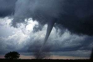
A tornado in central Oklahoma, United States
U
- unstable air mass
- Any air mass with high convective instability, characterized by dramatic vertical air currents.
- updraft
- upper-air chart
- upper-air sounding
- upper-level low
- upper-level outflow
- upslope fog
- urban heat island (UHI)
- An urban or metropolitan area within which air temperatures are significantly warmer than in surrounding rural or uninhabited areas as a result of human activities, especially the artificial modification of land surfaces and the generation of waste heat by energy usage. Urban heat islands can greatly influence precipitation, air quality, and the likelihood of certain weather phenomena in the vicinity of large cities, though not all cities have a distinct urban heat island.
- US Standard Atmosphere
- University Corporation for Atmospheric Research (UCAR)
V
- valley breeze
- valley exit jet
- vertical draft
- See updraft.
- vertically integrated liquid (VIL)
- An estimate of the total mass of precipitation contained in a cloud, obtained by measuring the intensity of radar echoes returned from the atmosphere.
- vertical wind shear
- virga
- virtual temperature ()
- The temperature of a moist air parcel at which a theoretical dry air parcel would have a total pressure and density equal to those of the moist parcel.
- visibility
- visual flight rules (VFR)
- A set of regulations under which a pilot operates an aircraft in weather conditions generally clear enough to allow the pilot to see where the aircraft is going, as opposed to instrument flight rules, under which operation of the aircraft primarily occurs through referencing the onboard instruments rather than through visual reference to the ground and environs.
- Von Kármán constant
- Von Kármán vortex street
- Von Kármán wind turbulence model
- vortex
- A region within a fluid in which the flow revolves around an axis line, which may be straight or curved. Vortices are a major component of turbulence and may be observed in many types of meteorological phenomena, including the winds surrounding a tropical cyclone, tornado, or dust devil.
- vorticity

W
- wall cloud
- A large, localized, persistent, and often abrupt lowering of cloud that develops beneath the surrounding base of a cumulonimbus cloud and from which tornadoes sometimes form.
- warm front
- A type of front located at the leading edge of a warmer air mass as it overtakes a cooler air mass that is moving more slowly in the same direction. Warm fronts lie within broader troughs of low pressure than cold fronts, which sometimes follow them, and the temperature difference between the air masses they separate is often greater. Stratiform clouds, fog, and steady rain with occasional thunderstorms often precede the boundary as it moves. In surface weather analysis, warm fronts are symbolized by a red line with semicircles pointing in the direction of travel.
- water vapor
- Water in its gaseous state. Water vapor is ubiquitous in the atmosphere, being continuously generated by evaporation and removed by condensation, and plays a major role in numerous meteorological processes.
- waterspout
- weak echo region (WER)
- weather
- The state of the atmosphere at a given time and location. Weather is driven by a diverse set of naturally occurring phenomena, especially air pressure, temperature, and moisture differences between one place and another, most of which occur in the troposphere.
- weather balloon
- A high-altitude balloon used to carry scientific instruments into the atmosphere, which then measure, record, and transmit information about meteorological variables such as atmospheric pressure, temperature, humidity, and wind speed by means of a radiosonde or other measurement device, often one which is expendable.
- weather bomb
- See explosive cyclogenesis.
- weather forecasting
- The application of science and technology to predict the conditions of the atmosphere at a given time and location. Weather forecasts are made by collecting quantitative data about the current state of the atmosphere at a given place and then using meteorology to project how the atmosphere will change. Forecasting is important to a wide variety of human activities, including business, agriculture, transportation, recreation and general health and safety, because it can be used to protect life and property.
- weather front
- See front.
- weather map
- A map which displays various meteorological features across a particular area for a particular point or range of time. Weather maps often use symbols such as station models to conveniently present complicated meteorological data. They are used for both research and weather forecasting purposes.
- weather modification
- Weather Prediction Center (WPC)
- Weather Surveillance Radar (WSR)
- 1. In the United States, WSR-1, WSR-57, WSR-74, and WSR-88D.
- 2. In Canada, the Canadian weather radar network (WKR and CWMN).
- weather reconnaissance
- weather satellite
- weather spotting
- The act of observing weather, often on the ground, for the purpose of reporting to a larger group or organization, such as the U.S. National Weather Service.
- weather station
- Any facility, either on land or at sea, with instruments and equipment for measuring atmospheric conditions in order to provide information for weather forecasts and to study the weather and/or climate.
- weather vane
- An instrument (often an architectural ornament) used to indicate the direction of the wind.
- Weatherwise
- A photographically adorned general interest weather magazine that frequently publishes articles on tornadoes and other severe weather.
- wet-bulb temperature
- wet-bulb globe temperature
- wet season
- whirlwind
- Any vertically oriented rotating vortex of air that develops as a result of turbulent air currents created by heating and flow gradients. Examples include major whirlwinds such as tornadoes, waterspouts, and landspouts and minor whirlwinds such as gustnadoes and dust devils.
- wildfire
- willy-willy
- See dust devil.
- wind
- The bulk movement of air within the Earth's atmosphere. Wind occurs on a wide range of scales, from very strong thunderstorm flows lasting tens of minutes to milder local breezes lasting a few hours to global atmospheric circulations caused by the differential heating of the Equator and the poles and the Earth's rotation. Winds are often referred to by their strength and direction; the many types of wind are classified according to their spatial scale, their speed, the types of forces that cause them, the regions in which they occur, and their effects.
- wind chill
- A meteorological index that estimates the effect of wind speed on the apparent temperature perceived by humans, particularly the decrease in human body temperature attributable to the movement of cold air. There is no universally agreed-upon formula for measuring or calculating wind chill, though it is commonly reported as a temperature. It is usually defined only for air temperatures at or below 10 °C (50 °F) and wind speeds above 4.8 km/h (3.0 mph).
- wind direction
- The direction from which a wind originates; e.g. a northerly wind blows from the north to the south. Wind direction is usually reported using cardinal directions or in azimuth degrees measured clockwise from due north. Instruments such as windsocks, weather vanes, and anemometers are commonly used to indicate wind direction.
- wind gradient
- wind gust
- A brief increase in the speed of the wind, usually lasting less than 20 seconds. Gusts are more transient than squalls. They are usually only reported by weather stations when the maximum or peak wind speed exceeds the average wind speed by 10–15 knots (12–17 mph).
- wind profiler
- wind shear
- Any difference in wind speed and/or direction over a relatively short distance in the atmosphere. Atmospheric wind shear is normally described as either vertical or horizontal.
- wind speed
- The measured speed of the air comprising a wind. Changes in wind speed are often caused by air parcels being exposed to pressure and temperature gradients in the atmosphere. Wind speed is measured with an anemometer, but may also be less precisely classified using the Beaufort scale.
- windstorm
- Any storm that produces or is characterized by very strong winds.
- windsock
- winter
- winter storm
- 1. Any storm which occurs during the local winter.
- 2. Any meteorological event in which varieties of precipitation which can only occur at low temperatures are formed, such as snow, sleet, or freezing rain. Such events are not necessarily restricted to the winter season but may occur in late autumn or early spring, or very rarely in the summer, as well.
- winter waterspout
- World Meteorological Organization (WMO)
X
Z
- Z-R relation
- Zdr
- zastrugi
- See sastrugi.
- zephyr
- zonal flow
- Zonda wind
- zud
See also
References
External links
This article is issued from Wikipedia. The text is licensed under Creative Commons - Attribution - Sharealike. Additional terms may apply for the media files.