Gitarama Province
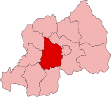
Gitarama was one of the former twelve provinces (intara) of Rwanda and was situated in the centre of the country, to the west of the capital Kigali. Gitarama Prefecture was created in 1959, increasing the number of prefectures of Rwanda from eight to nine. In 2002, it was renamed a province, as were the other prefectures of Rwanda.[1] It had an area of 2,187 square kilometres and a population of some 851,451 (2002 figures) prior to its dissolution in January 2006. Gitarama was divided into 8 districts: Muhanga, Kayumbu, Kabagali, Ntenyo, Kamonyi, Ntongwe, Ndiza and Ruyumba; and two towns: Ruhango and Gitarama. Gitarama bordered the provinces Butare, Gikongoro, Kibuye, Gisenyi, Ruhengeri, Kigali-Ngali and Kigali City Tourist attractions included the Kamegeri rocks and the Busaga forest.
References
- "Provinces of Rwanda". Statoids. Gwillim Law. 27 April 2010. Retrieved 17 May 2011.
- "Extending the Genocide (HRW Report - Leave None to Tell the Story: Genocide in Rwanda, March 1999)". Retrieved 2018-11-29.