Georgia State Route 268
State Route 268 (SR 268) is a 22.9-mile-long (36.9 km) southwest–northeast state highway located in the south-central part of the U.S. state of Georgia. It travels within portions of Coffee and Jeff Davis counties.
| ||||
|---|---|---|---|---|
 | ||||
| Route information | ||||
| Maintained by GDOT | ||||
| Length | 22.9 mi[1][2] (36.9 km) | |||
| Existed | 1950[3][4]–present | |||
| Major junctions | ||||
| West end | ||||
| East end | ||||
| Location | ||||
| Counties | Coffee, Jeff Davis | |||
| Highway system | ||||
| ||||

Route description
There is no section of SR 268 that is included as a part of the National Highway System.[5]
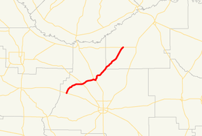
SR 268 begins at an intersection with SR 32 southeast of Ambrose. The route heads north-northeast and curves to the northeast to enter Ambrose. There, it crosses a Seaboard Coast Line railroad. It heads northeast, crosses the Seventeen Mile River, and intersects SR 206 (Bowens Mill Road). Farther to the northeast is Broxton, where it has a brief concurrency with US 441/SR 31 along Alabama Street. Northeast of Broxton, the route enters Jeff Davis County, and meets its eastern terminus, an intersection with SR 107 in Snipesville.[1][2]
History
SR 268 was established in 1950, with the part from SR 32 to Ambrose being paved.[3][4] In 1957, a section from Broxton just to the northeast was paved.[6][7] By 1960, the road was paved from its western terminus to just northeast of the Coffee-Jeff Davis County line. Also, the road was extended to Hazlehurst.[7][8] By 1988, the road's eastern terminus was truncated to Snipesville, where it is today.[9][10]
Major intersections
| County | Location | mi[2] | km | Destinations | Notes |
|---|---|---|---|---|---|
| Coffee | | 0.0 | 0.0 | Southern terminus | |
| Seventeen Mile River | 3.2 | 5.1 | Crossing | ||
| | 5.8 | 9.3 | |||
| Broxton | 9.6 | 15.4 | Southern end of US 441/SR 31 concurrency | ||
| 10.0 | 16.1 | Northern end of US 441/SR 31 concurrency | |||
| Jeff Davis | Snipesville | 22.9 | 36.9 | Northern terminus | |
1.000 mi = 1.609 km; 1.000 km = 0.621 mi
| |||||
See also
.svg.png)

References
- Georgia Department of Transportation (2013). Official Highway and Transportation Map (PDF) (Map) (2013–2014 ed.). Scale not given. Atlanta: Georgia Department of Transportation. § I12–J12. Retrieved February 17, 2013.
- Google (February 17, 2013). "Overview map of SR 268" (Map). Google Maps. Google. Retrieved February 17, 2013.
- State Highway Department of Georgia (1949). System of State Roads (PDF) (Map). Scale not given. Atlanta: State Highway Department of Georgia. OCLC 5673161. Retrieved February 15, 2013. (Corrected to April 1, 1949.)
- State Highway Department of Georgia (1950). System of State Roads (PDF) (Map). Scale not given. Atlanta: State Highway Department of Georgia. OCLC 5673161. Retrieved February 15, 2013. (Corrected to August 1, 1950.)
- "National Highway System: Georgia" (PDF). United States Department of Transportation. May 8, 2009. Retrieved February 17, 2013.
- State Highway Department of Georgia (1955). State Highway System and Other Principal Connecting Roads (PDF) (Map). Scale not given. Atlanta: State Highway Department of Georgia. OCLC 5673161. Retrieved February 17, 2013. (Corrected to June 1, 1955.)
- State Highway Department of Georgia (1957). State Highway System and Other Principal Connecting Roads (PDF) (Map). Scale not given. Atlanta: State Highway Department of Georgia. OCLC 5673161. Retrieved February 17, 2013. (Corrected to July 1, 1957.)
- State Highway Department of Georgia (1960). State Highway System and Other Principal Connecting Roads (PDF) (Map) (1960–1961 ed.). Scale not given. Atlanta: State Highway Department of Georgia. OCLC 5673161. Retrieved February 17, 2013. (Corrected to June 1, 1960.)
- Georgia Department of Transportation (1986). Official Highway and Transportation Map (PDF) (Map) (1986–1987 ed.). Scale not given. Atlanta: Georgia Department of Transportation. Retrieved February 17, 2013.
- Georgia Department of Transportation (1987). Official Highway and Transportation Map (PDF) (Map) (1987–1988 ed.). Scale not given. Atlanta: Georgia Department of Transportation. Retrieved February 17, 2013.
External links
