Georgia State Route 241
State Route 241 (SR 241) is a 5.6-mile-long (9.0 km) southwest-northeast state highway located in the southwestern part of the U.S. state of Georgia. It exists entirely within Decatur County.
| ||||
|---|---|---|---|---|
 | ||||
| Route information | ||||
| Maintained by GDOT | ||||
| Length | 5.6 mi[1] (9.0 km) | |||
| Existed | 1946[2][3]–present | |||
| Major junctions | ||||
| South end | ||||
| North end | ||||
| Location | ||||
| Counties | Decatur | |||
| Highway system | ||||
| ||||

Route description
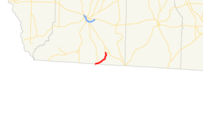
SR 241 begins at the Florida state line in southern Decatur County, where the roadway continues as County Road 65 (Attapulgus Highway). It heads east-northeast to an intersection with SR 309 (Fowlstown Road). Then, the road curves to the northeast, crossing over Little Attapulgus Creek and a CSX Transportation railroad line. It then heads north-northeast, until it enters Attapulgus, where it meets its northern terminus, an intersection with US 27 Business/SR 1 Business. Here, the roadway continues as Main Street.[1]
No section of SR 241 is part of the National Highway System, a system of routes determined to be the most important for the nation's economy, mobility and defense.[4]
History
SR 241 was established in 1946 along the same alignment as it runs today. Approximately half the route was paved.[2][3] By 1948, the remainder of the highway was paved.[3][5]
Major intersections
The entire route is in Decatur County.
| Location | mi[1] | km | Destinations | Notes | |
|---|---|---|---|---|---|
| | 0.0 | 0.0 | Florida state line | ||
| Taylor Crossing | 1.2 | 1.9 | |||
| Attapulgus | 5.6 | 9.0 | Northern terminus; roadway continues as Main Street. | ||
| 1.000 mi = 1.609 km; 1.000 km = 0.621 mi | |||||
See also
.svg.png)

References
- Google (February 25, 2013). "Overview map of SR 241" (Map). Google Maps. Google. Retrieved February 25, 2013.
- State Highway Department of Georgia (January 1, 1945). System of State Roads (PDF) (Map). Scale not given. Atlanta: State Highway Department of Georgia. OCLC 5673161. Retrieved February 25, 2013.
- State Highway Department of Georgia (1946). System of State Roads (PDF) (Map). Scale not given. Atlanta: State Highway Department of Georgia. OCLC 5673161. Retrieved February 25, 2013. (Corrected to November 7, 1946.)
- "National Highway System: Georgia" (PDF). United States Department of Transportation. May 8, 2009. Retrieved February 25, 2013.
- State Highway Department of Georgia (1948). System of State Roads (PDF) (Map). Scale not given. Atlanta: State Highway Department of Georgia. OCLC 5673161. Retrieved February 25, 2013. (Corrected to February 28, 1948.)