Georgia State Route 135
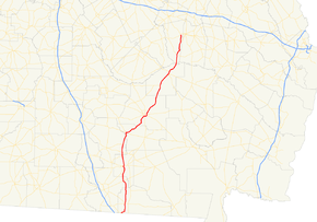
State Route 135 (SR 135) is a 130-mile-long (210 km) state highway in the south-central part of the U.S. state of Georgia. It connects the Florida state line with Higgston, via Lakeland, Willacoochee, Douglas, and Hazlehurst. It travels concurrently with U.S. Route 221 for extensive distances, a short piece in Lakeland and a longer one from Douglas to Uvalda.
| ||||
|---|---|---|---|---|
 | ||||
| Route information | ||||
| Maintained by GDOT | ||||
| Length | 130 mi[1] (210 km) | |||
| Major junctions | ||||
| South end | ||||
| North end | ||||
| Location | ||||
| Counties | Echols, Lanier, Lowndes, Berrien, Atkinson, Coffee, Jeff Davis, Montgomery | |||
| Highway system | ||||
| ||||

Route description
SR 135 begins at the Florida state line intersecting with County Road 141 (CR 141) south.[1] In Echols County it intersects SR 94, and SR 376.[2] SR 135 enters Lowndes County west of Valdosta. The only major junction in the county is with US 84/SR 38.[3] SR 135 then enters Lanier County south of Stoctkon. In downtown, it travels concurrently with US 221/SR 31 for a short distance. North of Lakeland, it travels concurrently with SR 64.[4] SR 135 enters southeast of Nashville. Just north of the county line, SR 64 splits off and joins SR 168. SR 135 also intersects SR 76, which terminates at SR 135.[5] SR 135 enters Atkinson County south of Willacoochee. In Willacoochee, it travels concurrently for a short distance with US 82 and SR 520.[6] SR 135 enters Coffee County south of Douglas, where it also travels parallel to a former Central of Georgia Railway right-of-way. In Douglas, it travels concurrently with SR 206 before the latter terminates. At the terminus, SR 135 travels concurrently with US 221 again. Together, they intersect SR 32, SR 158, and SR 206 Conn. before leaving Douglas.[7] SR 135 enters Jeff Davis County southwest of Hazlehurst. It intersects SR 107 just north of Denton; SR 107 terminates at SR 135. In Hazlehurst, US 221 splits off for a short way, while SR 135 picks up SR 135 Conn. SR 135 then picks US 221 back up, heading north. They then travel concurrently with US 23, US 341, SR 19, and SR 27. After intersecting SR 19 Conn, these roads split off.[8] SR 135 enters Montgomery County south of Uvalda. In Uvalda, US 221 splits off at an intersection with SR 56. North of Uvalda, SR 135 intersects SR 130. In Higgston, SR 135 terminates at US 280, SR 15, SR 29, and SR 30.[9]
Major intersections
| County | Location | mi[1] | km | Destinations | Notes |
|---|---|---|---|---|---|
| Echols | | 0.0 | 0.0 | Florida state line | |
| | 7.3 | 11.7 | Eastern terminus of SR 376 | ||
| | 7.6 | 12.2 | |||
| Lowndes | Naylor | 22.2 | 35.7 | ||
| Lanier | | Southern terminus of unsigned SR 135 Loop | |||
| | Eastern terminus of SR 31 Conn. | ||||
| | 30.4 | 48.9 | Southern terminus of SR 135 Byp. | ||
| | Northern terminus of unsigned SR 135 Loop | ||||
| Lakeland | 31.1 | 50.1 | South end of US 221/SR 31 concurrency | ||
| 31.7 | 51.0 | South end of US 129/SR 11/SR 37/SR 122 concurrency | |||
| 31.7 | 51.0 | North end of US 129/SR 11/SR 37/SR 122 and US 221/SR 31 concurrencies | |||
| 31.8 | 51.2 | South end of SR 11 Byp. concurrency | |||
| 31.9 | 51.3 | North end of SR 11 Byp. concurrency | |||
| 32.2 | 51.8 | Northern terminus of SR 135 Byp. | |||
| | 38.9 | 62.6 | South end of SR 64 concurrency | ||
| Berrien | | 40.2 | 64.7 | North end of SR 64 concurrency | |
| | 45.4 | 73.1 | Eastern terminus of SR 76 | ||
| Atkinson | Willacoochee | 53.0 | 85.3 | South end of US 82/SR 520 concurrency | |
| 53.7 | 86.4 | North end of US 82/SR 520 concurrency | |||
| Coffee | Douglas | 69.6 | 112.0 | South end of SR 32 Truck/SR 158 Truck/SR 206 concurrency | |
| 70.1 | 112.8 | North end of SR 206 concurrency; south end of US 221 concurrency | |||
| 71.7 | 115.4 | North end of SR 158 Truck concurrency | |||
| 72.6 | 116.8 | North end of SR 32 Truck concurrency; south end of SR 32 concurrency | |||
| North end of SR 32 concurrency | |||||
| | 75.1 | 120.9 | Eastern terminus of SR 206 Conn. | ||
| Jeff Davis | | 91.2 | 146.8 | Eastern terminus of SR 107 | |
| Hazlehurst | 102 | 164 | Northern terminus of SR 135 Conn.; southern terminus of US 221 Truck/SR 135 Truck | ||
| 103 | 166 | South end of US 23/US 341/SR 19/SR 27 concurrency (northbound only) | |||
| Northern terminus of SR 19 Conn.; connects the two directions of US 221/SR 135 | |||||
| 103 | 166 | North end of US 23/US 341/SR 19/SR 27 concurrency (northbound only) | |||
| Montgomery | Uvalda | 116 | 187 | North end of US 221 concurrency | |
| Petross | 125 | 201 | Southern terminus of SR 130 | ||
| Higgston | 130 | 210 | Northern terminus | ||
1.000 mi = 1.609 km; 1.000 km = 0.621 mi
| |||||
Special routes
Lakeland loop route
| |
|---|---|
| Location | South of Lakeland |
| Length | 2.5 mi[10] (4.0 km) |
State Route 135 Loop (SR 135 Loop) is a 2.5-mile-long (4.0 km) unsigned loop route south of the city limits of Lakeland, consisting entirely of Burnt Church Road. It begins at an intersection with SR 135 south of Darsey Pond, then curves to the northeast. At Union Church and the cemetery across the street from it, the road begins to curve to the northwest and then travels to the west just south of the Lakeland city limits. The highway intersects SR 135 Byp. (South Oak Street) before finally terminating at another intersection with the SR 135 mainline (South Mill Street). Burnt Church Road continues to the west as an unnumbered street leading to US 221.
The entire route is in Lanier County.
| Location | mi[10] | km | Destinations | Notes | |
|---|---|---|---|---|---|
| | 0.0 | 0.0 | Southern terminus | ||
| | 2.5 | 4.0 | |||
| | 2.5 | 4.0 | Northern terminus | ||
| 1.000 mi = 1.609 km; 1.000 km = 0.621 mi | |||||
Lakeland bypass route
| |
|---|---|
| Location | Lakeland |
| Length | 1.6 mi[11] (2.6 km) |
State Route 135 Bypass (SR 135 Byp.) is a 1.6-mile-long (2.6 km) bypass route of SR 135 that is mostly within the city limits of Lakeland. It begins at an intersection with the SR 135 mainline just south of the Lakeland city limits, then intersects SR 135 Loop (only signed as Burnt Church Road) before entering the city. SR 135 Byp. intersects US 129/US 221/SR 11/SR 31/SR 37/SR 122 (Main Street) and travels concurrently with them for two blocks, then turns north onto North College Street in a one-block concurrency with SR 11 Byp., which turns left at East Church Avenue. SR 135 Byp. ends at another intersection with the SR 135 mainline near the Charles Knight Cemetery.
The entire route is in Lanier County.
| Location | mi[11] | km | Destinations | Notes | |
|---|---|---|---|---|---|
| | 0.0 | 0.0 | Southern terminus | ||
| | 0.1 | 0.16 | Unsigned highway | ||
| Lakeland | 1.2 | 1.9 | South end of US 129/US 221/SR 11/SR 31/SR 37/SR 122 concurrency | ||
| 1.3 | 2.1 | North end of US 129/US 221/SR 11/SR 31/SR 37/SR 122 concurrency; eastern terminus of SR 11 Byp.; south end of SR 11 Byp. concurrency | |||
| 1.4 | 2.3 | North end of SR 11 Byp. concurrency | |||
| 1.6 | 2.6 | Northern terminus | |||
1.000 mi = 1.609 km; 1.000 km = 0.621 mi
| |||||
Hazlehurst connector route
| |
|---|---|
| Location | Hazlehurst |
| Length | 0.70 mi[12] (1.1 km) |
State Route 135 Connector (SR 135 Conn.) is a 0.7-mile-long (1.1 km) connecting route of SR 135 that exists mostly within the city limits of Hazlehurst. It connects US 23/SR 19 (Alma Highway/Larry Contos Boulevard) with US 221/SR 135 (Jefferson Street/Cromartie Street). It consists of a southern part of Jefferson Street. The highway is entirely concurrent with US 221 Truck / SR 135 Truck.
The entire route is in Jeff Davis County.
| Location | mi[12] | km | Destinations | Notes | |
|---|---|---|---|---|---|
| | 0.0 | 0.0 | Southern terminus; south end of US 221 Truck/SR 135 Truck concurrency | ||
| Hazlehurst | 0.7 | 1.1 | Northern terminus of SR 135 Conn.; southern terminus of US 221 Truck/SR 135 Truck; north end of US 221 Truck/SR 135 Truck concurrency | ||
1.000 mi = 1.609 km; 1.000 km = 0.621 mi
| |||||
Hazlehurst truck route
| |
|---|---|
| Location | Hazlehurst |
| Length | 2.0 mi[13] (3.2 km) |
State Route 135 Truck (SR 135 Truck) is a 2.0-mile-long (3.2 km) truck route of SR 135 that exists mostly within the city limits of Hazlehurst. It is entirely concurrent with US 221 Truck. It begins at an intersection with US 221/SR 135 (Jefferson Street/Cromartie Street). It travels to the southeast on Jefferson Street, concurrent with US 221 Truck and SR 135 Conn., which both begin at this intersection, as well. The three highways cross over some railroad tracks of Norfolk Southern Railway (NS) and then leave the city limits. They intersect US 23/SR 19 (Alma Highway). Here, SR 135 meets its southern terminus, and US 221 Truck and SR 135 Truck turn left onto US 23/SR 19 onto Larry Contos Boulevard. The four highways travel to the north-northeast. Just before passing a Walmart Supercenter, they re-enter Hazlehurst. They cross over some railroad tracks of NS Railway and then intersect US 341/SR 27 (Golden Isles Parkway). Here, all six highways travel to the northwest. At Plum Street, the concurrency intersects the northbound lanes of US 221/SR 135 (since those highways travel through the city on one-way streets). At this intersection, US 221 Truck and SR 135 Truck meet their northern terminus.
The entire route is in Jeff Davis County.
| Location | mi[13] | km | Destinations | Notes | |
|---|---|---|---|---|---|
| Hazlehurst | 0.0 | 0.0 | Southern terminus of US 221 Truck/SR 135 Truck; northern terminus of SR 135 Conn.; south end of US 221 Truck and SR 135 Conn. concurrencies | ||
| | 0.7 | 1.1 | Southern terminus of SR 135 Conn.; south end of US 23/SR 19 concurrency | ||
| Hazlehurst | 1.6 | 2.6 | South end of US 341/SR 27 concurrency | ||
| 2.0 | 3.2 | Northern terminus of US 221 Truck/SR 135 Truck; north end of US 23/SR 19, US 221 Truck, and US 341/SR 27 concurrencies; northbound lanes of US 221/SR 135 | |||
1.000 mi = 1.609 km; 1.000 km = 0.621 mi
| |||||
See also
.svg.png)

References
- Google (December 10, 2011). "Overview map of SR 135" (Map). Google Maps. Google. Retrieved December 10, 2011.
- General Highway Map: Echols County, Georgia (PDF) (Map). Cartography by Office of Transportation Data. Georgia Department of Transportation. 2014. Retrieved March 5, 2017.
- General Highway Map: Lowndes County, Georgia (PDF) (Map). Cartography by Office of Transportation Data. Georgia Department of Transportation. 2016. Retrieved March 5, 2017.
- General Highway Map: Lanier County, Georgia (PDF) (Map). Cartography by Office of Transportation Data. Georgia Department of Transportation. 2013. Retrieved March 5, 2017.
- General Highway Map: Berrien County, Georgia (PDF) (Map). Cartography by Office of Transportation Data. Georgia Department of Transportation. 2013. Retrieved March 5, 2017.
- General Highway Map: Atkinson County, Georgia (PDF) (Map). Cartography by Office of Transportation Data. Georgia Department of Transportation. 2013. Retrieved March 5, 2017.
- General Highway Map: Coffee County, Georgia (PDF) (Map). Cartography by Office of Transportation Data. Georgia Department of Transportation. 2017. Retrieved March 5, 2017.
- General Highway Map: Jeff Davis County, Georgia (PDF) (Map). Cartography by Office of Transportation Data. Georgia Department of Transportation. 2013. Retrieved March 5, 2017.
- General Highway Map: Montgomery County, Georgia (PDF) (Map). Cartography by Office of Transportation Data. Georgia Department of Transportation. 2015. Retrieved March 5, 2017.
- Google (March 4, 2017). "Overview map of SR 135 Loop" (Map). Google Maps. Google. Retrieved March 4, 2017.
- Google (March 4, 2017). "Overview map of SR 135 Byp." (Map). Google Maps. Google. Retrieved March 4, 2017.
- Google (March 4, 2017). "Overview map of SR 135 Con." (Map). Google Maps. Google. Retrieved March 4, 2017.
- Google (March 5, 2017). "Overview map of SR 135 Truck" (Map). Google Maps. Google. Retrieved March 5, 2017.
External links
