Geologists Seamounts
Geologists Seamounts (alternatively named South West Hawaii Group[1]) are seamounts in the Pacific Ocean, 100 miles (160 km) south of Honolulu, Hawaii[2] and 100–200 kilometres (62–124 mi)[3] southwest from Big Island.[4] Clockwise from north they are named Perret, Jaggar, McCall, Pensacola, Daly, Swordfish, Cross, Washington and Ellis.[5] The seamounts developed during the Cretaceous,[6] about 80 million years ago, and there is no geological relationship to the neighbouring Hawaiian Islands[3] although there may be one to the Musicians Seamounts.[7]
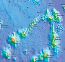
Bathymetric map
References
- Wessel, Pål; Keating, Barbara H. (10 February 1994). "Temporal variations of flexural deformation in Hawaii". Journal of Geophysical Research: Solid Earth. 99 (B2): 2751. doi:10.1029/93JB02876.
- "Project instruction for EX-15-04 Leg 3 : CAPSTONE NWHI Exploration, Leg III". NOAA. 2015. p. 3. Retrieved 25 March 2018.
- Wessel, Paul; Lyons, Suzanne (10 October 1997). "Distribution of large Pacific seamounts from Geosat/ERS-1: Implications for the history of intraplate volcanism". Journal of Geophysical Research: Solid Earth. 102 (B10): 22467. doi:10.1029/97JB01588.
- Wessel 1998, p. 403.
- "APPLICATION BRIEFS 2008" (PDF). University of Hawaii. 2008. p. 15. Retrieved 25 March 2018.
- Wessel 1998, p. 405.
- Hillier, J. K. (February 2007). "Pacific seamount volcanism in space and time". Geophysical Journal International. 168 (2): 877–889. doi:10.1111/j.1365-246X.2006.03250.x. ISSN 0956-540X.
Sources
- Wessel, Paul (1 May 1998). "An Empirical Method for Optimal Robust Regional-Residual Separation of Geophysical Data". Mathematical Geology. 30 (4): 391–408. doi:10.1023/A:1021744224009. ISSN 0882-8121.CS1 maint: ref=harv (link)
This article is issued from Wikipedia. The text is licensed under Creative Commons - Attribution - Sharealike. Additional terms may apply for the media files.