Gaularfjellet
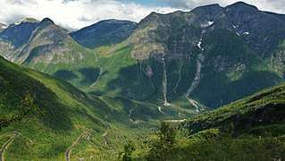
Gaularfjellet is a mountain area in central Vestland county, Norway. The mountains for the borders between the municipalities of Sunnfjord and Sogndal. Norwegian County Road 13 crosses the mountains through a pass that follows the river Gaula.[2][3]
| Gaularfjellet | |
|---|---|
 | |
| Highest point | |
| Peak | Sunnfjordbjørnen, Sunnfjord/Sogndal, Norway |
| Elevation | 1,615 m (5,299 ft) |
| Coordinates | 61.4135°N 6.5290°E |
| Geography | |
 Gaularfjellet Location of the mountain  Gaularfjellet Gaularfjellet (Norway) | |
| Location | Vestland, Norway |
| Range coordinates | 61.3541°N 6.4788°E[1] |
See also
- List of mountains of Norway
References
- "Gaularfjellet, Balestrand (Sogn og Fjordane)" (in Norwegian). yr.no. Retrieved 2019-06-30.
- "Gaularfjellet". Norwegian Public Roads Administration. Archived from the original on 5 October 2011. Retrieved 5 October 2011.
- Askheim, Svein, ed. (2019-09-20). "Gaularfjellet". Store norske leksikon (in Norwegian). Kunnskapsforlaget. Retrieved 2019-11-11.
This article is issued from Wikipedia. The text is licensed under Creative Commons - Attribution - Sharealike. Additional terms may apply for the media files.