Ganghwa Island
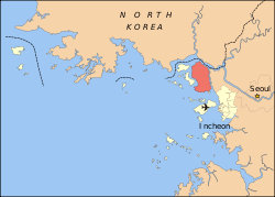
Ganghwa Island, also known by its native name Ganghwado, is a South Korean island in the estuary of the Han River. It lies in the Yellow Sea off Korea's west coast, separated from Gimpo on the South Korean mainland by a narrow channel spanned by two bridges and from Kaesong (Gaeseong) in North Korea by the main channel of the Han River.
Ganghwa Island | |
|---|---|
| Korean transcription(s) | |
| • Hangul | 강화도 |
| • Hanja | 江華島 |
| • Revised Romanization | Ganghwado |
| • McCune–Reischauer | Kanghwado |
 Ganghwa | |
 Map showing location of Ganghwa Island. | |
 Ganghwa Island Map showing location of Ganghwa Island. | |
| Coordinates: 37°42′N 126°26′E | |
| Country | South Korea |
| Area | |
| • Total | 302.4 km2 (116.8 sq mi) |
| Population (est.) | |
| • Total | 65,500 |
| • Density | 220/km2 (560/sq mi) |
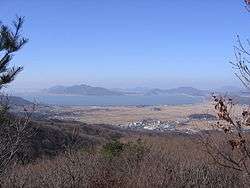
The island is strategically located, controlling access to the river which runs through the former Joseon and present South Korean capital Seoul. Its fortifications were repeatedly attacked during the 19th century. With an area of 302.4 km2 (116.8 sq mi), it now constitutes most of Ganghwa County, a division of Incheon Municipality. It has a population of about 65,500 people, half of whom live in Ganghwa Town (Ganghwa-eup) on the northeast.
Name
"Ganghwado" or "Ganghwa-do" (Korean: 강화도, formerly 江華島) is Korean for "Island Made Prosperous", "Illustrious", or "Flourishing by the River" in reference to its formation from the silt carried downriver by the Han. Former romanizations include Kang-hoa[1] and Kang-hwa.
Geography
This island lies in the estuary of Korea's Han River. It is 302.4 km2 (116.8 sq mi), measuring 28 kilometers (17 mi) long and 22 kilometers (14 mi) wide, making it the 4th largest island in South Korea. Its highest point is Mani-san (469 m or 1,539 ft above sea level).
Climate
| Climate data for Ganghwa (1981–2010, extremes 1971–present) | |||||||||||||
|---|---|---|---|---|---|---|---|---|---|---|---|---|---|
| Month | Jan | Feb | Mar | Apr | May | Jun | Jul | Aug | Sep | Oct | Nov | Dec | Year |
| Record high °C (°F) | 12.6 (54.7) |
17.4 (63.3) |
22.3 (72.1) |
29.2 (84.6) |
31.0 (87.8) |
33.2 (91.8) |
35.5 (95.9) |
35.8 (96.4) |
31.7 (89.1) |
28.0 (82.4) |
23.8 (74.8) |
16.0 (60.8) |
35.8 (96.4) |
| Average high °C (°F) | 1.2 (34.2) |
4.1 (39.4) |
9.4 (48.9) |
16.3 (61.3) |
21.3 (70.3) |
25.4 (77.7) |
27.5 (81.5) |
29.0 (84.2) |
25.3 (77.5) |
19.3 (66.7) |
11.2 (52.2) |
4.1 (39.4) |
16.2 (61.2) |
| Daily mean °C (°F) | −3.8 (25.2) |
−1.0 (30.2) |
4.3 (39.7) |
10.7 (51.3) |
15.9 (60.6) |
20.3 (68.5) |
23.5 (74.3) |
24.5 (76.1) |
19.8 (67.6) |
13.4 (56.1) |
6.0 (42.8) |
−0.8 (30.6) |
11.1 (52.0) |
| Average low °C (°F) | −8.7 (16.3) |
−6.1 (21.0) |
−0.9 (30.4) |
5.1 (41.2) |
10.8 (51.4) |
15.8 (60.4) |
20.4 (68.7) |
20.8 (69.4) |
15.1 (59.2) |
7.8 (46.0) |
0.8 (33.4) |
−5.6 (21.9) |
6.3 (43.3) |
| Record low °C (°F) | −22.5 (−8.5) |
−19.4 (−2.9) |
−11.3 (11.7) |
−4.4 (24.1) |
1.6 (34.9) |
6.9 (44.4) |
12.7 (54.9) |
12.5 (54.5) |
3.0 (37.4) |
−4.2 (24.4) |
−12.0 (10.4) |
−19.8 (−3.6) |
−22.5 (−8.5) |
| Average precipitation mm (inches) | 17.7 (0.70) |
19.2 (0.76) |
39.6 (1.56) |
66.9 (2.63) |
108.8 (4.28) |
123.4 (4.86) |
358.2 (14.10) |
326.6 (12.86) |
165.4 (6.51) |
51.2 (2.02) |
50.7 (2.00) |
18.8 (0.74) |
1,346.7 (53.02) |
| Average precipitation days (≥ 0.1 mm) | 5.7 | 4.7 | 6.2 | 6.7 | 8.4 | 8.7 | 13.9 | 12.0 | 7.3 | 5.7 | 7.0 | 6.6 | 92.9 |
| Average snowy days | 7.3 | 4.3 | 2.4 | 0.2 | 0.0 | 0.0 | 0.0 | 0.0 | 0.0 | 0.1 | 1.5 | 5.1 | 20.6 |
| Average relative humidity (%) | 66.1 | 63.0 | 62.9 | 62.8 | 69.5 | 75.3 | 82.7 | 80.3 | 74.8 | 69.9 | 68.2 | 67.3 | 70.2 |
| Mean monthly sunshine hours | 179.8 | 188.3 | 218.3 | 233.3 | 241.4 | 221.0 | 173.2 | 201.3 | 214.4 | 220.4 | 170.0 | 165.9 | 2,431.5 |
| Percent possible sunshine | 58.7 | 61.8 | 58.9 | 59.0 | 54.8 | 50.0 | 38.6 | 47.7 | 57.4 | 63.3 | 55.7 | 55.6 | 54.6 |
| Source: Korea Meteorological Administration[2][3][4] (percent sunshine and snowy days)[5] | |||||||||||||
Regional specialties
- Ganghwa Island Turnip
Ganghwa Island's Turnip (cultivar of Brassica rapa) has been cultivated in Ganghwa for over a thousand years. The moisture content is over 90% and its main component is carbohydrate. They are a taproot vegetable that has a smell of mustard and tastes like ginseng. This distinctive taste is due to its dark purple part.
Both turnip seeds and full grown turnip are used as an ingredient for folk remedies and oriental medicine because it contains beneficial ingredients for our body. The turnip's leaves have a lot of nutrients and vitamins and the roots contain tryptophan and glycyrrhizin. It has the trait of anticancer activity and helps to cure dermatopathy, digestion organs, tuberculosis and respiratory disease, and anti-bacterial effect.[6]
- Anticancer action: Glucosinolate is contained (an anti-cancer substance) and it is most effective for lung cancer.
- Dermatopathy: It cures scars and contused wounds
- Digestion organs: It is effective curing cold and aching digestion organs
- Tuberculosis and respiratory disease: Stops coughing and prevents tuberculosis
- Anti-bacterial effect: rapine has an effect of suppressing bacterium, fungi and parasite from reproducing[7]
- Saja bal yukssuk
In Ganghwa Island, there is a specific kind of wormwood that is more effective and outstanding than regular wormwood.
Alleged benefits:
- Helps blood flow smoothly.
- Warms the body up.
- The wormwood helps to lower high blood pressure, diarrhea and dizziness.
- Wormwood is also good for women.
- Hwamunseok
Ganghwa's Hwamunseok (woven sedge mat) is an elegant and refined handicraft that dates back to Goryeo Dynasty.
It is cool and absorbs moisture well in the summer, while also preventing chill in the winter.
Therefore, Hwamunseok helps to maintain one's health.
- Yellow sweet potato
It is produced only in Gangwha. Unlike normal sweet potato, it is high in sugar and very soft, which is good for digestion.
Festivals
- Goryeo Azalea Festival
- Date: The middle of April
- Place: Dolmen square, Goryeo mountain
There is a yearly azalea festival held every mid-April in Ganghwa. During the festival, you can make azalea hwajeon which is a pan-fried sweet rice cake with flower petals. Also, a photo and postcard exhibition will take place.
- Ganghwa Salted Shrimp Festival
- Date: Every year at the beginning of October
- Place: Oepo-ri dock
Every year at the beginning of October, the salted shrimp festival is held at the Oepo-ri dock, in Ganghwa. You can watch many different kinds of performances and song festivals. Also, you can make Kimchi using cabbage and salted shrimp. There is a salted shrimp auction, but it is almost free. If a manager specifies the price to be 1,000 won, it will be sold to the person who called 900 won rather than 10,000 won.
- Ganghwa Foundation Day Grand Festival
- Date: October 1–3
- Place: Chamseongdan on Mt. Mani
Every year, Ganghwa Foundation Day Grand Festival is held at Chamseongdan on Mt. Mani. Chamseongdan was an altar used to offer sacrifices to heaven by Dangun, a legendary founding father of Gojoseon. Ganghwa Foundation Day Grand Festival is held from October 1 until October 3. At this festival, you can see seven Taoist fairies who dance holding fans. On October 3, you can also see carrying sacred fire.
Tourist attractions
Ganghwa Nadeulgil
Ganghwa Nadeulgil is a walking tour line consisting of 20 courses. People can witness history from the prehistoric age to the Joseon dynasty and also experience the natural ecologic environment of global mud flat and the migrate habitats of birds.
Recently, the ‘나들길 app’ was launched so that people can enjoy a walking tour more conveniently.
Seokmodo
It is 1.5 km west at Ganghwado. The area is 42.31 km2 and the length of the coastline is 42.0 km. Seokmodo is located at 126°20′ degrees east longitude and 37°40′ degrees north latitude. The island currently home to around 1,800 inhabitants. ‘Seokmodo’ appears in 『Daedongyeojido』 and can be interpreted as ‘Water flowing around a corner’ or ‘A rocky beach corner’.
There is 'Ganghwa Nadeul-gil'. Starting from Seokpori dock, tourist can walk by dark-colored ditch and see the vast tidal mudflats unfold in front of tourist. After passing by Bomun dock and a fishing port while walking along the Jebang-gil road, visitors will pass through a quiet and peaceful forest. At the far end of the forest, there is Seokmodo Island's one and only beach called Minmeoru Beach. Keep walking along the Jebang-gil with the sea on left and Mount Nakga on the right, and tourist will arrive at Bomun Temple where this course ends. *Course: Seokmodo dock - Maeeum-ri dock - Fishing port - Minmeoru Beach -Eoryujeonghang - Bomunsa (10 miles, 5 hours. Level: Easy)[8]
Pungmul Market
Ganghwa Pungmul Market is a place with long history. A new building for the market was built in 2007, and you can buy grains, vegetables, fruits, etc. in a cheap price.
Dealt goods: grains, vegetables, fruits, salted seafood, fresh meat, dried fish, tofu, ginseng, etc.
The Goryeogung Palace Site
This was the palace site of Goryeo from 1232 to 1270.
position: Incheon Metropolitan City Ganghwa-gun the north gate street(Bungmun street) 42
The Goryeogung Palace Site leads to the cherry blossom tree path on a northern hill (Bukssan) so many people come to see the cherry blossoms in spring and are often used as hiking trails.
Mani Mountain
Mani Mountain is the highest mountain in Ganghwa.
There is the home of Chamseongdan Altar where Dangun Wanggeom performed ancestral rites in the top of this mountain.
Tidal energy
Ganghwa Tidal Power Generation Company comprises Dae woo, Lotte, Hyundae and Kolon. They have signed a memorandum of understanding regarding the joint development of tidal power generation and reinforcement facilities in the Ganghwa County of Incheon in South Korea. This 1.4 trillion won worth project will be financed through private capital. 1.4 generators with a capacity of 30 MW will be fitted in 4-km-long tidal wave dam that will be constructed around the Ganghwa Islands. This project is expected to be completed in 2023.
History
As the location of the primary fortifications protecting the Joseon capital of Seoul from foreign invasion, Ganghwa Island was the site of several punitive expeditions during the 19th century. The mass execution of Catholic French missionaries and Korean converts under the ministry of the Heungseon Daewongun in the mid-1860s led to a French invasion in 1866 which held the island for several weeks, although Admiral Roze was unable to sail up the shallow and uncharted Han River and fortified monasteries prevented overland incursion. In 1871, a Korean assault on an American diplomatic mission led to the Battle of Ganghwa. Rear Admiral Rodgers took five forts on the island but withdrew after the Koreans refused to meet for negotiations. Following a diplomatic incident related to Korea's refusal to recognize the imperial status of the sovereign of Japan in 1868, the forts at Ganghwa fired upon a Japanese boat from the surveying gunship Un'yō in 1875. During the Japanese Battle of Ganghwa, the Un'yō's captain Inoue Yoshika silenced the batteries with superior firepower, then landed a raiding force which plundered local communities. The Imperial Japanese Navy then blockaded the area and compelled the 1876 Treaty of Ganghwa, which opened Korea to Japanese commerce. When the Mongolia aggression Goryeo, Choe-woo the Goryeo's general changed the capital to Ganghwa at sixth aggression. And they prepared the war. At that time, Goryeo's religion was Buddhism. They want to save their country, so they borrowed the power of Buddha. In this process, the Tripitaka Koreana was made. The Tripitaka Koreana was called Palmandaejanggyeong. It is comprehensive collection of 80,000 Buddhist scriptures.
Invasion of Korea by the three U.S. warships in 1871
Cause
In 1866, the General Sherman arrived at Pyongyang through the Daedong River. One of crew was a Welsh pastor named Thomas, who was traveling for missionary work to Joseon. Initially, Pyongyang governor Park Gyu-su, who was Park Ji-won's grandson, informed the crew about his refusal to allow trade and advised them to go back. Disputes worsened between the crew and eventually, after the crew kidnapped a Joseon official sent on board and held him hostage, the Korean authorities sank the boat and killed the crew that did not die in the sinking.
Process
In 1871, during the Joseon expedition, America finally decided to open a port. The United States of America ordered the Joseon expedition to Asia led by Fleet Commander Rogers.
On June 1, The United States of America led sounding navigation of Ganghwa Strait. When the fleet arrived to Sondolmok, it was attacked from the coastline by Ganghwa artillery unit.
The American fleet scorched the Chojijin Fort and took it over with naval gunfire. The American army then took over Deokjjinjin Fort on June 11, and began the Gwangseongbo operation. After an hour of shelling of land and sea, the American army captured and took over Gwangseongbo.
Result
The scale that damage of human life caused by war. First, damage of the US was: 3 people dead in battle, 10 people wounded. On the other hand, the damage to Joseon was: 350 people dead in battle, 20 people wounded. It can be seen that the damage to Josean is larger than the damage to the United States.
Heungseon Daewongun is the father of King Gojong. Heungseon Daewongun erected Cheokhwabi in each region of the whole country. In every Cheokhwabi he put the inscription: “If you don’t fight against the western barbarians, it means you negotiate for peace. And that is selling our country.” What is more, he strengthened the national isolation policy. Therefore, Cheokhwabi is a monument to exclude westerners.
Cheokhwabi is located in Deokseong-ri, Bureun-myeon, Ganghwa-gun. The name of the one located in Ganghwa-gun is Deokjinjin gyeong-gobi, it is also called ‘Cheokhwabi of the sea.’ There is a sentence in the front of the monument written in characters, that says: ‘it is guarding the sea gate, thus foreign ship cannot pass. There is a bullet mark remained on it.
Ganghwa Treaty
After the Unhyo Incident, Japan demanded unilateral compensation from Joseon. Joseon was coerced to grant Japan the right of extraterritoriality, permission for ocean measurement and the opening of three ports in Pusan, Incheon and Wonsan. Although normally extraterritoriality applies to diplomats, common Japanese who lived in Joseon also gained this right. Before, Joseon was isolated because of the Daewongun's closed-door policy. By signing the contract Joseon was to appear on the global stage. The terms of the treaty were unequal, and are regarded as the first step towards Japanese colonialism.
See also
| Wikimedia Commons has media related to Ganghwa Island. |
- Geography of South Korea
- Islands of South Korea
- Ganghwa County
References
Citations
- EB (1878), p. 393.
- "평년값자료(1981–2010) 강화(201)" (in Korean). Korea Meteorological Administration. Retrieved 2011-05-11.
- "기후자료 극값(최대값) 전체년도 일최고기온 (℃) 최고순위, 강화(201)" (in Korean). Korea Meteorological Administration. Retrieved 9 February 2017.
- "기후자료 극값(최대값) 전체년도 일최저기온 (℃) 최고순위, 강화(201)" (in Korean). Korea Meteorological Administration. Retrieved 9 February 2017.
- "Climatological Normals of Korea" (PDF). Korea Meteorological Administration. 2011. p. 499 and 649. Archived from the original (PDF) on 7 December 2016. Retrieved 9 February 2017.
- "강화도 순무". 인천광역시. Retrieved 1 August 2017.
- "순무". 농식품백과사전. Retrieved 1 August 2017.
- "Hidden trails that highlight Korean beauty". Korea JoongAng Daily. Retrieved 2018-05-25.
Bibliography
- , Encyclopædia Britannica, 9th ed., Vol. VI, New York: Charles Scribner's Sons, 1878, pp. 390–394.