Gaià River
The Gaià is a 59 km long river in Tarragona Province, Catalonia.
| Gaià | |
|---|---|
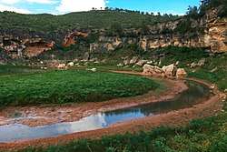 The Gaià River at l'Altrera near Santes Creus | |
| Location | |
| Country | Spain |
| Physical characteristics | |
| Source | |
| ⁃ location | Santa Coloma de Queralt |
| Mouth | |
⁃ location | Mediterranean Sea |
⁃ elevation | 0 m (0 ft) |
| Length | 59 km (37 mi) |
| Basin size | 423.8 km2 (163.6 sq mi) |
| Discharge | |
| ⁃ average | 0.57 m3/s (20 cu ft/s) |
Course
Its source is at Santa Coloma de Queralt, situated in the Catalan Central Depression, gathering the waters of the Serra de Brufaganya and Serra de Queralt mountain ranges. It flows through deep gorges across the Catalan Pre-Coastal Range and then close to Santes Creus and, at the end, into the Mediterranean at the Tamarit Castle, Tarragonès, near Altafulla forming a coastal lagoon separated from the sea by a sandbar. The river mouth is a protected area.[1]
Tributaries
Its main tributaries are:[2]
- Torrent de Claret
- Riu de baix
- Torrent del Biure
- Torrent Sant Magí
- Torrent de Vallespinosa
- Torrent de Rupit
- Torrent Rubio
- Torrent de Pinatelles
- Riu de Boix
- Torrent d'en Serrat
- Torrent de Biany
- L'Escurri
See also
References
- "Desembocadura del riu Gaià; Fitxes descriptives de zones humides" (PDF). Departament d'Agricultura, Ramaderia, Pesca, Alimentació i Medi Natural de la Generalitat de Catalunya (CC-BY-SA). Archived from the original (PDF) on 2014-03-23. External link in
|publisher=(help) - Josep M. Calbet& Teresa M. Jové, Alt Camp: marc físic marc humà, Generalitat de Catalunya. Valls May 1983 ISBN 84-300-8291-3
External links
- Gaià River – On the route of the castles in Camp de Tarragona region – part I., in Catalonia, Spain (in English)

This article is issued from Wikipedia. The text is licensed under Creative Commons - Attribution - Sharealike. Additional terms may apply for the media files.